
Updated Mar 1, 2025
A peek at a 1931 road map of Connecticut can be a disorienting experience. The cities and towns (except for Deep River) are the same as today; and you'll recognize a handful of highways, namely US 1, 5, 6, and 7, and state routes 8, 10, 12, and 32. But Route 10 is in the wrong place. US 7 veers off into New York. And no route other than the first eight looks familiar at all.
Connecticut's original highway system evolved over the course of eight years. Then, on Jan. 1, 1932, it was scrapped, and replaced with a new system that grew into the one we use today. I call this the "Great Renumbering", but that's not an official term. I tend to use the term "1920s" in this context to refer to the span starting with the first route numbers in 1923 and ending with the Great Renumbering in 1932.
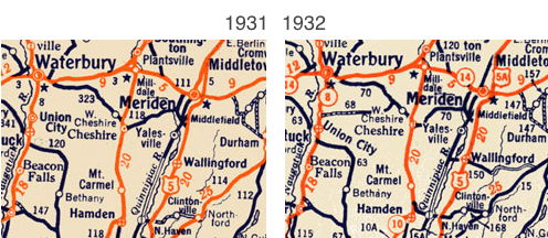 Left: South Central Connecticut, 1931.
In 1916, the state started marking routes with a system of colored bands on poles. East-west routes had red bands, north-south were blue, and diagonal or secondary routes were yellow. As more roads were built, however, this system became less effective; motorists needed a better way to identify routes.
Highway commissioners, hotel associations and members of the Automobile Club of America worked on a solution, culminating in an early April 1922 conference in New York announcing a proposed uniform numbering system for the entire United States.
The route marking standard of 1922 was the following:
... a painted square, one foot wide and one foot high. The background is a bright yellow surrounded by a border of black two inches wide. Inside this border are the numerals painted in black with a wide stroke.
New England and New York adopted the system. Other states such as Wisconsin (the pioneer in this respect) had also starting numbering their highways. The idea caught on so quickly that the New England Interstate system was short-lived: in 1926, a nationwide system of U.S. routes supplanted it. Many New England Interstate routes (such as NE 2) became US routes (such as US 5).
In April 1922, Connecticut reported it was ready to start signposting NE Route 1 as soon as weather permitted.
In November 1922, a Providence Evening Tribune article, giving driving directions to the Yale-Harvard game in New Haven, mentioned New England Routes 12 and 32.
Widespread adoption of state route numbers by the driving public appeared to get started in late 1923. Connecticut published a map that year, possibly for internal use, of 8 New England routes and 25 signposted state routes, the highest number being 128. By December 1923, newspaper articles were referring to some roads by route number.
In 1924, no signed routes were added. The 3 categories of road on the 1923 and 1924 maps were:
Numbered routes were mostly, but not 100%, improved. Many roads on the map were not numbered.
In late 1924, Highway Commissioner John A. MacDonald recommended building out a system of state aid roads, to replace the ad hoc application of funding and construction outside the trunk line system.
In 1925, state maps introduced dozens of new signed routes, under a new system:
 Connecticut's 1925 highway map introduced more than 50 new numbered routes, a set of green State Aid roads numbered in the 300s, and even more State Aid roads without numbers -- ancestors to today's "secret routes". If you're feeling lost, Route 111 is now Route 66, and Route 17 became "before it was a freeway" Route 2.
In 1926, about 5 new north-south state aid routes were added, reaching 368.
In 1927, the state map introduced a new detail: some numbered routes were signposted, and some were not, "as of yet." I don't know whether the intent was to eventually signpost all routes under 399. But in 1927, even some trunk line routes (like 153) were not posted, yet some state aid roads (like 340) were.
A few more routes were added in the "100s" during next few years, reaching 226.
The New England Interstate route numbers were adopted in 1922; Connecticut added its state highway routes in 1923. From that point up to the 1932 renumbering, this convention, based on the New England Interstate system, was in place:
Connecticut gave numbers to State Highways (SH) and State Aid roads (SA). Some routes were signposted, some not. For now, I tend to refer to both SH and SA as SH unless the distinction matters (and I have information about it).
Route numbers were added chronologically and as needed. This resulted in an organically grown, complicated system of short routes. By the early 1930s, the Highway Department saw the need to reorganize the system, even at the cost of a highly disruptive change.
On January 1, 1932, Connecticut renumbered nearly all its routes, in a sweeping change intended to simplify route markings and make navigation easier. Free road maps showing all the changes were distributed statewide a few weeks later.
The Great Renumbering was announced as part of a four-state agreement, including Massachusetts, Rhode Island, and New York. It should be clarified that the other four states did not renumber their entire systems as well; Massachusetts and Rhode Island had abandoned the three-digit state route system earlier, around 1928. However, cross-border route changes, like those for Route 14 and Route 32, were coordinated with neighbor states.
Many of today's state routes were created then, even though most have been modified since then. A very few (such as Route 45) appear to have had no location changes at all.
Having said that, the 1932 renumbering is merely the final product of a series of discussions and plans beforehand, with different roads and route numbers considered. One document has surfaced (a planning map from November 1931) and more may be found. I discuss those in Planning Connecticut's Big 1932 Route Renumbering.
More state routes cross the border into Massachusetts than into New York or Rhode Island. Perhaps coincidentally, in 1932 the Massachusetts highway department was drawing up, for the first time, its own state highway map, instead of using maps from private companies. To prepare for this, state officials contacted neighboring states to see if they planned any changes in their state route numbers. Connecticut certainly did. The resulting agreement included new Connecticut routes 15, 41, 83, 93, 183, 193, and 197 extending into Massachusetts.
Here's a condensed listing of what route number went where in the 1920s. After the 1920s route number (referred as "SH"), I show its approximate path using present-day route numbers ("CT", "US"). Key: [SL - state line; UC - under construction; RI - Rhode Island; MA - Massachusetts; amb. - ambiguous]
| 101 | CT 198 from US 6 to US 44; then US 44 E to RI SL (1923-31) |
| 102 | CT 85, Colchester to New London (1923-31) |
| 103 | CT 14, from CT 12 to RI SL (1923-31) |
| 104 | CT 17, from CT 2 to CT 66 (1923-31) |
| 105 | CT 190, from US 5 to CT 32 (1923-31); extended to MA SL along 190 and old W. Cross Hwy (1931) |
| 106 | CT 81, entire length (1923-31) |
| 107 | CT 74; from CT 83 to US 44 (1923-31) |
| 108 | New State Rd, Tolland Tpke from US 6 to CT 83; then CT 83 N to MA SL (1923-31) |
| 109 | US 44, from CT 31 to CT 198 (1923-31); UC between 30 and 74 in 1926. |
| 110 | CT 159, Hartford to CT 75; then CT 75 N to Suffield; then old CT 75 NE back to 159 (1923-29) (by 1931, Route 110 followed CT 159 for entire length). |
| 111 | CT 322/66, from CT 10 to CT 2 (1923-26); extended to US 6 in Windham (1926-31) |
| 112 | CT 17, from CT 66 to CT 77; then CT 77, entire length (1923-31) |
| 113 | CT 372, from CT 10, Plainville to CT 71, New Britain; then CT 71 and New Britain Ave. into Hartford. (1927, 31) (before 1926, also extended to CT 8). |
| 114 | CT 17, from CT 77 to New Haven (1923-31) UC south of CT 22 in 1926. |
| 115 | CT 185, all (1923-31) |
| 116 | CT 10, from CT 20 to CT 4 (19233-31) |
| 117 | CT 34, all (1923-31) |
| 118 | CT 10, from New Haven to Milldale (CT 322) (1923-31) |
| 119 | US 6 from Danbury to the New York state line (1923-26) |
| 120 | CT 63, from CT 8 to New Haven (1923-31) |
| 121 | US 44, from US 7 to NY SL (1923-31) |
| 122 | CT 25, from US 1 to US 6 (1923-31) |
| 123 | CT 4, from US 7 to CT 8, and US 202, from CT 8 to US 44 (1923-31) |
| 124 | CT 58, all (1923-31) |
| 125 | CT 67, from US 7 to US 6 (1923-31) |
| 126 | US 7, from US 1 to CT 35 (1923-29) |
| 127 | old CT 130, from US 7 to NY SL (1923-31) |
| 128 | US 202, from Danbury to CT 8 (1923-29); New Milford to CT 8 (1930-31) |
| 129 | CT 39/55, near Gaylordsville and US 7 (1923-31) |
| 130 | CT 63, from CT 4 to CT 64 (1926, 28, 31); CT 61 instead of 63 between 6, 109 (1929) |
| 131 | CT 37, Chimney Hill Rd and Briggs Hill Rd in Sherman; west from US 7 to NY SL |
| 132 | CT 43, all, and CT 63 from 63/43 junction to US 7 (1923-31) |
| 133 | CT 20, from CT 8 to CT 10 (1923-31) |
| 134 | US 7, New Milford to Canaan (1923 - c.1929); US 7 at that time went along NY 22! |
| 135 | old CT 141, Branford |
| 136 | CT 39 from US 7/CT 55 to Sherman center; then 37 south of there (1923-31) |
| 137 | CT 101, from 169 to 12 (1923-31) |
| 138 | CT 4, from CT 10 to US 44/CT 179, 179 to SR 565, to US 44 (1923-31) |
| 139 | CT 101, from CT 12 to RI SL (1926, 28, 29, 31); but appears to take older route slightly to south |
| 140 | CT 80, from CT 22 to CT 77 (1926, 29) |
| 141 | CT 14 and 14A, from US 6 to CT 12 (1923-31) |
| 142 | CT 171 from 12 to 169; CT 169 from there to MA SL (1928, 29, 31); also seen along CT 169 from 97 to 138 (1930) |
| 143 | CT 116, all (1923-31) |
| 144 | CT 205, all (1923-31) |
| 145 | along old Ousatonic Turnpike (Housatonic R, northeast bank), New Milford - Shelton |
| 146 | CT 195 and CT 89, from Willimantic to Union |
| 147 | CT 67, from CT 63 to US 6 (1923-31) |
| 148 | CT 149, all (1929, 31) [It almost got renamed to itself!] |
| 149 | old CT 15 (near I-84 path now), from CT 32 E to MA SL (1928, 29). In 1930, this became part of SH 105, and SH 149 was applied to CT 4 between US 7 and CT 41. |
| 150 | CT 156, from CT 82 to US 1 (1923-31) |
| 151 | old CT 197, from CT 32 to MA SL (1926, 28, 29, 31) |
| 152 | CT 45, all (1928, 29, 31) |
| 153 | CT 82, all (1928, 29, 31) |
| 154 | CT 47, all (1928, 29); in 1931, included Middle Rd Tpke, White Deer Rock Rd, and Charcoal Ave in Middlebury as well. |
| 155 | old CT 130, from 7 to 202 (1930) |
| 156 | CT 25, from US 6 to US 7 (1928, 29, 31) |
| 157 | US 6, from CT 10 to CT 72 (1931); used Bristol Tpke |
| 158 | old section of old CT 57 (Newtown Tpke), from CT 58 northeast to CT 302 (1929-31) |
| 159 | old CT 134 (1930) |
| 160 | CT 177, Unionville - Plainville (1926) |
| 161 | CT 302, from CT 58 to Newtown Tpke (1930) |
| 162 | old CT 72, from US 5 to New Britain, then 71 north into New Britain (1929, 31) |
| 163 | CT 4, from US 202 to Burlington town line (1931); to US 202 (1930) |
| 164 | CT 83, CT 2 to US 6 (1929-31) |
| 165 | CT 94, CT 2 to Buckland School, just E of CT 83 (1930, 31) |
| 166 | CT 30, from CT 74 to CT 190 (1925, 28, 29, 31) |
| 167 | CT 151, from CT 66 TO CT 149 (1930) |
| 168 | CT 87, all (1928, 29, 31); also seen for CT 4, from CT 69 to Torrington (1931) |
| 169 | CT 148, small part in Chester (1930) |
| 170 | New London Tpke, from CT 2 to CT 32 (1929) |
| 171 | CT 142, all (1931) |
| 172 | CT 69, from Waterbury to US 6 (1928, 29, 31) |
| 173 | CT 110, west of 108, Shelton (1926-31) |
| 174 | CT 183, from US 44 to CT 182; poss. CT 182 to US 44 (1926, 28, 31) (in 1929, former is SA 314) |
| 175 | CT 80, most (1925, 1929-31) |
| 176 | CT 33, from US 7 to US 1 (1929, 30) |
| 177 | CT 16/old 171, from CT 66 to CT 149 (1928, 29, 31) |
| 178 | CT 71, from Meriden to New Britain (1929, 31) |
| 179 | CT 2A, from CT 12 to CT 2 (1925, 29) |
| 180 | part of CT 107 and 58, near CT 302 in Bethel (1925, 29, 30) |
| 181 | CT 30, CT 83 to CT 74 (1931) |
| 182 | CT 133, all (1926, 29, 31) |
| 183 | CT 198, from US 44 to CT 171; then CT 171 from there to CT 12 (i.e. old CT 91) (1931) |
| 184 | CT 123, from CT 124 to US 7 (1928, 29, 31) |
| 185 | CT 193 and 200, short loop of 12, Thompson |
| 186 | Hartford Turnpike, State St, New Haven area (1926, 31); also, _both_ the previous def. and a road near CT 58 in Bethel (1930) |
| 187 | CT 169, from CT 2 to CT 97 (1930) |
| 188 | CT 161, all (1929) |
| 189 | not yet found (a few higher odd-numbered roads were found) |
| 190 | CT 79, all (1928, 29, 31) |
| 191 | not yet found |
| 192 | not yet found |
| 193 | old CT 106, Easton |
| 194 | CT 39, from New Fairfield Center to Sawmill Center |
| 195 | CT 121, all (1930, 31) |
| 196 | CT 199, all (1930) |
| 197 | not yet found |
| 198 | two conflicting descriptions, even on same map: a) old 199 south of CT 67, 1930; b) Litchfield Tpke, from 42/63 to 69/63, Bethany |
| 199 | CT 157, from CT 66 to CT 147 (1930) |
| 200 | CT 115 (1930) |
| 202 | CT 72, from US 6 to CT 4 (1931) |
| 204 | Old CT 179, along east side of what is now Barkhamsted Reservoir, from CT 20 to US 44 (1930, 31) |
| 206 | CT 189, 20 to MASL (1930) |
| 208 | CT 191, from 190 to 140 (1930) |
| 210 | CT 195, from US 44 to CT 89 (1930) |
| 212 | not yet found |
| 214 | CT 289, all (1930) |
| 216 | CT 49, all (1931) |
| 218 | not yet found |
| 220 | Cross Highway, from SH 180 (CT 107) to SH 158 (CT 58), Redding |
| 222 | CT 203, all (1930) |
| 224 | old 159 (Cherry Hill Rd) (1930) |
| 226 | old CT 150, from US 5 to CT 17 (1931) |
| 299 | CT 341, from US 202 to CT 45 (1930) |
| 300 | CT 104, all (1926, 29) |
| 301 | CT 182, all (1929); CT 112 (1930). Perhaps 1929 was a typo; see SH 174. |
| 302 | CT 124, all (1926, 29) |
| 303 | Thompsonville Rd, Suffield, across river to Main St, Enfield (1926); part of old CT 190 |
| 304 | CT 33, from US 7 to CT 35 (1926, 29) |
| 305 | CT 315, all (1928, 31); but also seen for CT 136 in Darien (1930) |
| 306 | CT 59, Bridgeport to Easton, then west to end at CT 58 (192x, 29) |
| 307 | CT 191/140, from US 5 to CT 83 (1928, 29, 31) |
| 308 | CT 111, from CT 25 to CT 34 (192x, 29) |
| 309 | CT 128, all (1926) |
| 310 | CT 209, 109 from US 202 to CT 61 (1925, 1929, 31) |
| 311 | old CT 184 (now parts of 178 and 187) (1929, 2x) |
| 312 | CT 272, from CT 4 to US 44 (1926, 28, 29, 31) |
| 313 | CT 30, from US 5 to CT 83, South Windsor (1929, 2x) |
| 314 | CT 183, north of US 44 (1929) |
| 315 | CT 31, south of US 44 (1926) |
| 316 | old CT 8 (better yet, old CT 65), from CT 34 to US 1 (1926, 29) |
| 317 | Silver Lane/Roberts St, from US 5 to US 6, E. Hartford/Manchester (1928, 31) |
| 318 | CT 137, all (1931) |
| 319 | New Lane, Mill St, West St, Cromwell (1930) |
| 320 | CT 177, from CT 72 to US 44 (1929) |
| 321 | CT 138, amb. (1926, 29) |
| 322 | CT 152, all (1929, 2x) |
| 323 | CT 70, west of CT 10 (1929, 31) |
| 324 | CT 122 (1930) |
| 325 | CT 68, from CT 10 to CT 8 (192x), and also CT 70, from CT 10 to Meriden (1930) |
| 326 | CT 120, all (192x) |
| 327 | CT 182 and 182A, from 44 to 183 (1931) |
| 328 | CT 187, from CT 189 to CT 190/168; then east to CT 75 (192x) |
| 329 | CT 102, all (1929-31) [does not include 1950s extended CT 102] |
| 330 | CT 147 (roughly), all (1929, 2x) |
| 331 | CT 184, from CT 12 to CT 201; then CT 201 to CT 2 (1929, 2x) |
| 332 | CT 153, all (1929, 2x) |
| 333 | CT 156, south of US 1 (1929, 31) |
| 334 | CT 32, from CT 190 to MA SL; continues as MA 32A (1929, 31) |
| 335 | older CT 136, from Norwalk to Southport; all south of US 1 (192x) |
| 336 | CT 193, all to MA SL (1926, 29, 31) |
| 337 | CT 162/122, from Milford to New Haven; ends on Beach St at Marathon Ave (1926-31) |
| 338 | CT 154, loop south of US 1 only (1929, 2x) |
| 339 | CT 73 (roughly), from Waterbury to Watertown at US 6 (192x) |
| 340 | CT 213, south from US 1 to dead end at beach (1929, 2x) |
| 341 | CT 63, from CT 8 to CT 188; then CT 188 to CT 64 (1931) |
| 342 | CT 215, east half only, with dead end at beach (192x) |
| 343 | old CT 20, Windsor Locks to East Granby (now crosses airport) (1926) |
| 344 | CT 27, all (192x) |
| 345 | CT 97, 3-cornered jog between US 44, US 44/169, Putnam (1926) |
| 346 | CT 3, from CT 372 to CT 66 (192x) |
| 348 | Lacy Rd, from CT 63 to 69; then CT 69, from CT 68 to old US 6A, Waterbury (1929-31) |
| 350 | along US 6, Watertown to Thomaston (1929, 2x) |
| 354 | CT 207, east of CT 87 (1929-31); also CT 97 from 207 to Norwich (1930) |
| 356 | CT 169, from CT 12/97 (roughly) to CT 138; then 138 east to 12 again (1929, 2x) |
| 358 | North St, Greenwich (1926, 29, 31) |
| 360 | CT 41, from 343 to NY SL (1931) (in 1929, part of US 7) |
| 362 | old CT 75, all (1931) (1929: part of CT 110) |
| 364 | CT 163, south of CT 82, Montville |
| 366 | SR 534 and CT 85, from Manchester to Colchester (1926-31) |
| 368 | CT 108, CT 8 to Stratford (1926) |