US 44 is one of just a few highways in Connecticut that cross two state lines: the New York line at Salisbury and the Rhode Island line at Putnam.
Some wags say US 44 has only two-thirds the kicks of US 66; but it's still a nice drive. In the countryside, it's a scenic two lane road, connecting the two "quiet corners" of the state. In Winsted it widens to four lanes, with a landscaped median in parts.
At Canton, US 44 merges with US 202 in a channelized Y-intersection and widens to four lanes. This busy, commercialized arterial continues toward Hartford, while US 202 turns north with Route 10 at Avon.
Ascending Talcott Mountain, Route 44 has a narrow median divider, part of safety improvements in the area. The highway continues through West Hartford and Hartford, then crosses the Bulkeley Bridge with US 6 and I-84. It splits off from both at the eastern bank, but rejoins US 6 in Manchester.
At Bolton Notch, just east of the end of I-384, US 44 splits from US 6 in a Y-interchange that resembles the 44/202 split in Canton, except the Bolton one is grade separated.
At two lanes again, US 44 passes through small towns until reaching Putnam, now a major attraction for antique shoppers; and then into Rhode Island.
US 44 Turnpikes
US 44 follows the path of several 19th-century turnpikes in Connecticut. From North Canaan to New Hartford, the Greenwoods Turnpike was in operation from about 1799 to 1872. (The present-day Greenwoods Road name in Norfolk looks back to this.)
From New Hartford to the Hartford city line, US 44 continues along the old Talcott Mountain Turnpike, which connected to the Greenwoods pike, was incorporated in 1798, and might have been made free about the same time the Greenwoods was. These two turnpikes were part of a chain of roads extending to Albany, New York.
From East Hartford to Eastford, US 44 mainly follows the Boston Turnpike, a 1797 road that eventually left the state near its northeastern corner, on the way to Boston.
US 44 History
Route Numbering and Location
Once the state started numbering roads, it went a little crazy. By 1927, good old Trunkline 12 had been sliced up into 101, 109, 3, 10, 17 and 121.
As its out-of-place number implies, US 44 was not one of the original US routes in Connecticut (US 1, US 5, US 6 and US 7). It was commissioned on March 1, 1935 (along with US 202) to encourage tourism.
The western half (between Hartford and Canaan) was originally part of a cross-state NE-17; the small part west of US 7 was state highway 121 (1923-1932) and CT 199 (until 1934). Between 1932 and 1934, all of US 44 east of US 7 was part of a long Route 101.
The highway over Avon Mountain, from Mountain Road in West Hartford, opened to traffic in September 1929. This may have been built as four lanes; a paving contract in 1938 refers to existing four-lane pavement east of Avon center.
In 1935, US 44 inherited most of the Route 101 alignment. West of Hartford, that's most where it remains today; eastward, there have been some changes.
In East Hartford, US 44 eastbound originally turned south, not north, on Main Street, then followed Silver Lane into Manchester, met up again with US 6, and then went through Bolton Notch, Coventry, Mansfield Depot, and Willington. In 1943, shortly after the Charter Oak Bridge opened, the state decided to place US 6 on Silver Lane and move US 44 to its current alignment on Burnside Avenue.
In 1952, officials in West Hartford and the state discussed options for widening or relocating US 44 in the Bishops Corner area (at Route 218); these included two one-way bypasses, forming a loop, or relocating US 44 to the north entirely.
US 44A...
As the Wilbur Cross Highway was upgraded toward Union in 1948, US 44 was rerouted between Manchester and Willington; the new alignment followed Route 15 (now I-84) from US 6 in Manchester to the Route 74 interchange in Tolland. There, US 44 left Route 15 and followed present-day Route 74 to the 74/44 intersection. The old portion of US 44 through Bolton and Coventry became US 44A.
On Dec. 1, 1982, all this was undone: US 44A was deleted, US 44 moved back, and Route 74 re-extended; US 44 and Route 74 returned to their early 1940s alignments.
Freeway plans - Hartford area
In the early 1950s, a relocated US 44 freeway was proposed, passing from West Hartford to East Hartford near the Bloomfield and Windsor town lines, and using a new bridge across the Connecticut River. It would be the northernmost of the east-west freeways planned for the immediate Hartford area. Connections to other freeways would include the proposed Woods River Freeway (Route 189, since cancelled), the North Meadows Freeway (today's I-91), and a US 5 relocation east of the river. More details on this proposal, from west to east:
a bypass of Avon Mountain (OK, not much detail here)
an east-west highway between Tower Avenue in Hartford and Park Avenue (Route 178) in Windsor
a new bridge near where the Bissell Bridge (I-291) was eventually built
a new highway leading to today's I-84 at Buckland Street
By the late 1950s, the state was instead planning Interstate 291, whose corridor would have been a few miles north of the US 44 proposal. This segment of I-291 encountered fierce opposition circa 1970 and did not survive.
Freeway plans - Northwest Connecticut
In 1956, Connecticut attempted to have the US 44 corridor west of Hartford added to the interstate system; though this was turned down, the state proceeded with planning an freeway there in the 1960s.
In 1963, the state proposed a 32-mile, four-to-six lane freeway leading from I-291 to North Canaan, slated sometime after 1975. In 1966, this was added to the state's highway needs list. The first 5.6 miles, from West Hartford to Simsbury, were on the priority list. A $75 million section to Canton would start by 1975, and the remaining 26 miles (about $90 million) would start sometime thereafter.
In late 1967, highway officials were planning to get funding for a portion of relocated US 44 by about 1972. This segment would lead from I-291 to a point on present-day US 44 near Route 167. A plan presented by engineers at Yale included 4 interchanges:
directional interchange with I-291, just south of present-day US 44
folded diamond interchange with present-day Route 10
Because the freeway would start with a planned interchange with I-291 in the reservoir areas of West Hartford, US 44 plans were somewhat dependent on the controversial I-291 plans. In 1970, the state decided not to build US 44 over the reservoir, and debated dropping the planned tunnel through Avon Mountain as well.
In 1973, Gov. Meskill cancelled the project in favor of mass transit for the northwest corridor -- but Avon, Simsbury, and Canton have proven too lightly populated for public mass transit.
In January 1973, the DOT dropped the Canaan to Winchester portion of US 44 from its long-range freeway plan.
In 1975, however, the state's 1975 Master Transportation Plan called for allocating $133 million for "studies" of the corridor, from West Hartford to North Canaan.
Lakeville and Salisbury, 1954
US 44 and Route 41 overlap between the villages of Lakeville and Salisbury, in the town of Salisbury. Both highways are state scenic roads along their entire lengths in town. It's hard to imagine a freeway being built there, and no such plans exist today. Many years ago, one plan did.
In June 1954, state highway commissioner G. Albert Hill spoke to a group of residents at the Lakeville Chamber of Commerce, describing a possible alignment of a US 44 freeway in Lakeville and Salisbury. The route would start near US 44 at Indian Mountain Road and proceed east, skirting Wononskopomuc Lake to the north. Crossing the Town Grove at Lakeville, it would follow the abandoned railroad tracks (still explorable as the Railroad Ramble) through downtown Lakeville. It would continue along the track alignment to meet US 44 again east of downtown Salisbury, near Cobble Road.
There were questions, including about a former Department booklet explaining an even earlier US 44 plan in a different location, though Commissioner Hill said that was before his time. A resident engineer in Salisbury recommended a more rural aligment, roughly following US 7 to Route 112, then going west in the valley south of Route 112 toward Amenia, N. Y.
In September 1954, Commissioner Hill visited the area again with a new bit of information: in the Department's opinion, a freeway for Route 44 would not be needed west of Canaan for at least 50 years. However, east of Canaan, the state would have to start work on a freeway within the next few years, to have US 7 and US 44 connect with the Mass Pike and northwestern Connecticut Towns. Also, US 7 in Canaan, though listed as a long range proposal, would start in the following year, 1955. Commissioner Hill then reportedly disparaged the worries of Lakeville residents who understood the June 1954 freeway alignment as a "serious final project".
For residents wanting to keep the lakefront and their town unspoiled, those few months in 1954 must have been quite dramatic. Decades later, with the scenic road designation in place, US 44 is now protected from any construction that changes the character of the road (much less building a freeway).
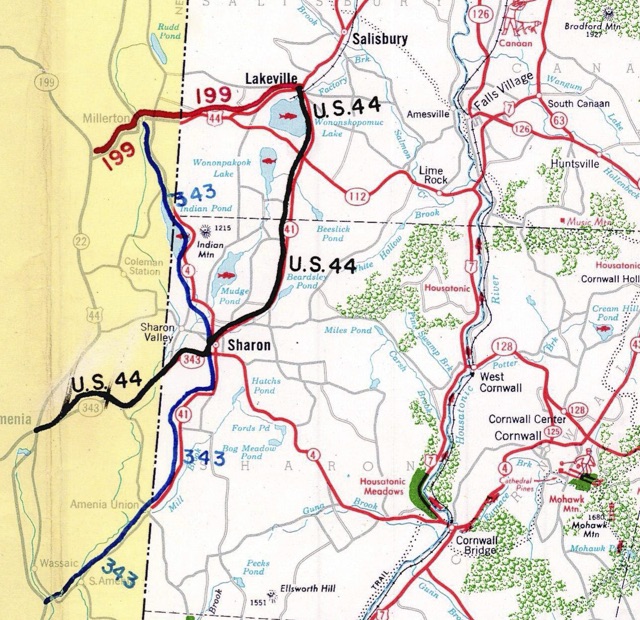
US 44 route swap proposed, 1959
In late 1959, the states of New York and Connecticut advised the American Association of State Highway Officials (AASHO) of their intent to reroute US 44 along safer, better roads in the vicinity of the state line. The change would make US 44 a bit more serpentine in Connecticut, but remove a long overlap with NY 22 and simplify navigation in New York.
From Lakeville, Conn., US 44 would follow today's Route 41 into Sharon, and then Route 343 into New York State to Amenia, to rejoin existing US 44. Route 343 would be redefined to cross into Connecticut using Route 41, then cross back into New York replacing Connecticut Route 4 (now Route 361), to end at Millerton, N. Y. New York state would reuse the 361 number for old Route 343 between Millbrook and Dover Plains; Route 361 would never have existed in Connecticut. The remainder of US 44 between Millerton and Lakeville would return to its previous designation before US 44 was created: Route 199. Not mentioned in the the application or related news articles: Route 199 in Roxbury and Washington would need to be renumbered; following common DOT practice, the new number would have likely been 299.
US 44 would have been a bit longer in Connecticut, totaling 111.48 miles -- still a bit shorter than US 6 (116.33 miles).
To sum up:
US 44 west of Lakeville becomes Route 199
Route 41 south of Lakeville is divided into US 44 and Route 343
Route 343 west of Sharon becomes part of US 44
Route 4(361) northwest of Sharon becomes part of Route 343
Route 199 becomes (probably) Route 299
The plan originated in New York State, but opposition in Millerton, which the new US 44 would have bypassed, appears to have helped scuttle it. There was also some opposition in Sharon, where the new US 44 would have gone through. Many Lakeville and Salisbury residents, having dealt with state plans to build a US 44 freeway in the area, were wary of the proposal until it was made clear that only signs would be moved.
In the end, US 44 was not changed in the area.
Proposed US 44 swap, 1959
Connecticut and New York proposed rerouting US 44 along Routes 41 and 343, which were better roads at the time. Diagram from Connecticut route change application to AASHO in 1959.
Norfolk alignment
In 1971, with the "freeway to Canaan" plan still active, the state held a corridor hearing in Norfolk. Out of the three northern alignments and one southern route proposed, Norfolk officials preferred the southern route. I haven't seen more details at this time.
Winsted alignment
In August 1955, two hurricanes struck Connecticut, causing severe flooding in many locations. In Winsted, the Mad River overflowed its banks and destroyed nearly all businesses on Main Street (US 44). Main Street used to have shops on both sides; but the side facing the river was never rebuilt.
In 1961, the state started work on a dam and reservoir west of Winsted for flood control. The project included relocating 2.3 miles of US 44. Traveling east on US 44 from Rugg Brook Road, drivers can see a fenced-off road leading southeast. That's the older alignment of US 44. It originally continued past the dam site to rejoin the "future" alignment (today's US 44) west of Route 183.
The new segment was reportedly built to freeway standards and would have been used for one direction of a future US 44 freeway.
Other relocations and improvements
There are short streets named "Old Route 44" in Abington (west of Route 97) and Eastford (east of Route 198), suggesting earlier reroutings, but I don't have any information yet.
The Y-interchange at Bolton Notch where US 6 and 44 separate was built in 1953. With the US 6 freeway extension effectively dead, the interchange may stay as is.
US 44 was widened to four lanes in Canton in 1984.
Streetscape improvements: Main Street, Winsted
In the late 1990s, Winsted was mulling over streetscape improvements to US 44, which is their Main Street. Their goals included shade trees and various traffic calming devices, including narrowing from four lanes to two; however, the state DOT informed the town that if lanes were removed, "[Winsted] could own the road too" - and pay for its upkeep.
Agreements were eventually reached, however. In 1998 work started on renovating Main Street, and by summer 2003 the work was almost complete. Main Street features a center divider with trees, new sidewalks, and new lampposts along the south side, which is a bank of the Mad River. There are fewer turning lanes, which is slowing traffic in the area.
US 44 Future
Other US 44 corridor plans
The freeway plan for US 44 has been abandoned, but other proposals to ease traffic in the Farmington Valley have been considered. (Some of these are already more than 20 years old, and probably should be moved out of "Future"...)
A 1997 plan called for two new highways, north and south of US 44. The north road would be two lanes, connecting Bloomfield, Avon, and Route 10 in Simsbury. The tunnel at Avon Mountain would make this road relatively expensive: $500 million.
The south road would extend from I-84 at Route 9 (the four-level stack interchange) as a four-lane highway, then narrow to two lanes and meet US 44 in Avon. A similar proposal – a $118 million four-lane road from the stack to Talcott Notch Road – was cancelled in 1998 because of environmental and residential obstacles.
Alternative proposals were not quite as interesting: a median strip on US 44, and additional left-turn lanes. Construction on the two new roads, if approved, would not have started for about five years.
Improvement west of Hartford proposed
In early 2001, the Capitol Region Council of Governments (CRCOG) unveiled its recommendations for improvements to the US 44 corridor from Canton to Hartford. Increasing safety is the main goal of most of the actions proposed. The roadway improvements include:
Talcott Mountain: widen to four lanes, provide 8-foot shoulders and a 4-foot painted median, and add left turn lanes at intersections. The steep grades and sharp curves here cause problems.
Avon and Canton commercial areas: add a 24-foot median to decrease left-turn accidents and provide an attractive boulevard.
Bishops Corner, West Hartford: provide a 4-foot raised median to decrease left-turn accidents.
US 44 at Route 179: eliminate dogleg and create a four-way intersection.
Interchange at Route 10 proposed
Westbound US 44 descends Talcott Mountain to reach Route 10 at a signalized intersection. On July 29, 2005, a runaway truck (failed brakes) caused four deaths and 19 injuries there, spurring calls for a safer descent and intersection. A median was added to US 44 here, and a westbound runaway truck ramp was installed in 2008. The biggest change proposed (but not implemented to date) was to grade separate Route 10, Nod Road, and US 44, and add connector roads. None of the alternatives was a true freeway interchange, but they all called for removing the traffic light on US 44.
Improve or remove Bolton Notch interchange proposed
The US 6/44 Y-interchange in Bolton opened in 1953. If I-84, I-384, or US 6 had been extended to Willimantic, that interchange would likely have been bypassed or replaced. With the new reality of no freeway expected in the area, planners have looked at rebuilding or replacing the interchange to better fit its new role, while addressing operational and safety issues.
The most radical plan in 2013 was to end I-384 at US 6/44 at a T-intersection, replacing the partial interchange where I-384 ends. Then the Bolton Notch interchange would also become a T-intersection. This option has advantages in safety and accessibility for pedestrians and bikes.
The other plan was to modernize both interchanges so that US 44 is the thru route, and I-384 exits to the right (westbound) and US 6 also enters to the right (westbound). In 2016, the preferred alterative resembles the second plan.
US 44 Sources
"Avon Mountain Road To Open September 15." Hartford Courant, Aug. 10, 1929.
"New State Map To Be Ready For Public In August." Hartford Courant, June 27, 1935.
"Bids Are Opened For Paving On Road To Winsted." Hartford Courant, Apr. 5, 1938.
"Advice May Be Sought On Relocating Route 44." Hartford Courant, June 23, 1952.
1955 HB-1228. An Act providing for the Reconstruction of a Highway in the Town of Pomfret. [US 44 from Route 101 to Putnam town line]
Preliminary Report on Proposed Sisson Avenue Connector and Woods River Circumferential Freeway of Hartford Metropolitan Area Freeway Study. M. Alfred Kaehrle, Dec. 31, 1955.
"An Application from the State Highway Department of Connecticut for the Relocation of US Route 44." Submitted Dec. 23, 1959.
"Rerouting Of Route 44 Merely Naming Device; Will Not Alter Roads." Lakeville [Conn.] Journal, Jan, 7. 1960.
Tri-State Transportation Committee. "Regional Highways: Status Report." Dated Nov. 1962.
" Overview of Improvements On Route 44 over Avon Mountain & Future Considerations To eliminate the at-grade intersection of Route 44/Route 10/Nod Road." ConnDOT presentation, dated April 2008.
"Route 44 Strategic Corridor Plan: Route 44/Route 6/I‐384 Interchange Assessment Summary." Capitol Region Council of Governments, dated September 2009.
"Route 6 Hop River Corridor Transportation Study." Capitol Region Council of Governments, dated 2013.
US 44 Links
Explore 44: a July 2014 series covering landmarks and history along US 44


 Connecticut and New York proposed rerouting US 44 along Routes 41 and 343, which were better roads at the time. Diagram from Connecticut route change application to AASHO in 1959.