Possibly Connecticut's first numbered highway, NE 1 became US 1 in Route markers for US 1 went up in late 1927 or early 1928, replacing the old NE-1 markers.

Updated Oct 20, 2018
 1920s era route markers, depicted on 1928 Rand McNally map.
In 1922, a consistent numbering system was established for major roads across New England, intended as a more usable replacement to the previous system: color-coded bands on telegraph poles. In all, 36 routes were numbered in this way. Though states began to abandon the system when the nationwide U.S. Route numbering was introduced in 1926, some of the New England route numbers (8, 10, 12, and 32) survive today in Connecticut.
This page discusses only the Connecticut routes.
In the early 1920s, only a few states had numbered highways; some others, including those in New England, used painted color bands on poles to mark routes. East-west routes had red bands, north-south blue, and diagonal or secondary routes were yellow. Highway commissioners, hotel associations and members of the Automobile Club of America worked on a solution for this, culminating in an early April 1922 conference in New York announcing a proposed uniform numbering system for the entire United States.
The plan divided the country into zones. Everything east of the Hudson belonged to the New England zone. National and interstate routes were allocated numbers between 1 and 99; state routes would start at 100. East-west routes would get odd numbers where possible, and north-south routes even. An exception was the Atlantic coast highway, to be called Route 1 (it's now US 1).
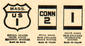
Markers were consistently colored: black on yellow. Interstate route numbers would be six inches high; state routes, four. (See illustration at above right, from a 1929 Rand McNally map.) The common practice was still to paint numbers directly on telephone or telegraph poles. For comparison, typical modern route marker signs are 24 inches square.
At the time of the conference, New England highway departments had already adopted the system, with Connecticut already painting signs for Route 1. In the following years, about 20 routes crossed New England. However, plans for making the system national were eclipsed by the establishment of the U.S. route system in 1926: New England route 1 became US 1, NE 2 became US 5, and so on. By 1929, Massachusetts had already abandoned the system, but Connecticut kept its state routes within the system until its wide-scale renumbering in 1932.
I'll talk only about the New England routes passing through Connecticut. My sources:
 |
|
Possibly Connecticut's first numbered highway, NE 1 became US 1 in Route markers for US 1 went up in late 1927 or early 1928, replacing the old NE-1 markers.
 |
|
NE-2 went mostly where US 5 does now. At the time, US 5 crossed the Connecticut River on the Bulkeley Bridge (the Charter Oak Bridge opened in 1942).
Route markers for US 5 went up in late 1927 or early 1928. The old NE-2 markers were removed later.
The 1922 plans were for NE-2 to continue past the Canadian border to Sherbrooke and Quebec City. Quebec appears not to have ever gone along with this idea.
 |
|
Most of it became US 6; but US 6 has moved over the years as well. NE-3 started in New York City, going north into White Plains and Bedford along present-day NY 22. It entered Connecticut in Ridgefield along present-day Route 35, then followed present-day US 7 into Danbury, where it picked up US 6. In Woodbury, NE-3 and US 6 continued east into Waterbury along present-day Route 64, continuing to Milldale, where Routes 10 and 322 meet now.
NE-3/US 6 continued north along present-day Route 10 to Farmington, then east along present-day Route 4 into Hartford. In Bolton, US 6 and NE-3 split, US 6 taking the northerly US 44/CT 31 route, while NE-3 took the "Suicide 6" route through Andover. In Willimantic, they merged again, and progressed eastward.
NE 3 markers were posted in summer 1922 in western Connecticut.
US 6 markers were installed in early 1928. NE-3 markers remained up as well, since the routes did not exactly coincide.
The 1922 plan called for NE-3 to turn north at Danielson (along present-day Route 12) and east at Putnam (entering Rhode Island via present-day US 44). By 1926, however, it went along US 6 through to the state line.
 |
|
Replaced by US 7. However, in those days, NE-4/US 7 veered west into New York along present-day Route 41. In the late 1920s, NE-4 still existed along 41, while US 7 entered Massachusetts where it does now. In 1928, US 7 was moved out of New York to its current western Connecticut route (not counting the freeway portions...)
US 7 markers in Connecticut went up in summer 1928.
 |
|
Became plain old Route 8 in Connecticut, Massachusetts and Vermont. In 1929 this route was 183 miles long. The south end of NE-8/Route 8 was Stratford, not Bridgeport, until 1951. More information: Connecticut Route 8.
 |
|
 |
|
 |
|
 |
|