
Updated Oct 20, 2018
The Charter Oak Bridge, carrying US 5 and state route 15 across the Connecticut River, connects Hartford and East Hartford south of both city centers. It opened during World War II and was the second bridge to cross the Connecticut in the Hartford area. In 1991 the original bridge was replaced, and now it serves as a critical link between I-91 and I-84.
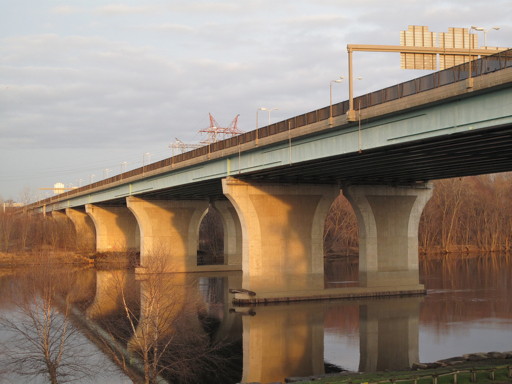 The new Charter Oak Bridge, completed in 1991, strikes a much more utilitarian profile than the original. Photo taken by Kurumi in 2009.
The Charter Oak, Connecticut's state tree, is featured on the state's quarter dollar coin. The large, ancient, gnarled tree, once standing in the Wyllys Estate in Hartford, became legend by serving as a hiding place for a document – the Charter – that the King's men meant to take by force in the late 17th century.
In 1662, the Connecticut Colony through diplomatic skill obtained a Royal Charter from King George II granting residents the right to "have and to hold forever this place in 'New England in America'" – to govern themselves. This was considered a diplomatic coup.
England eventually soured on the idea, and the King tried to negotiate with the colony to give up the Charter. After this failed, his men arrived in 1687 to confiscate the document. But as both parties sat in a meeting room to discuss the matter, the candles went out -- and moments later, after they were re-lit, the Charter was gone. The King's men went away empty-handed, and the colonials retrieved the Charter, hidden in a huge oak tree on the estate.
The first motor vehicle bridge across the Connecticut River at Hartford was the Bulkeley Bridge, which opened in 1908. During the early 20th century, the stone arch bridge carried US 5, US 6, US 44, New England Route 17, and state highway 101... all routes crossing the river.
In 1929 the General Assembly passed an act creating a commission to study the need for a second bridge across the Connecticut River at Hartford. The outcome was a proposed new bridge from Main and Pitkin Streets in East Hartford to Wyllys Street at Wethersfield Avenue in Hartford.
In 1931 the commission hired a design consultant. The new design was an 800-foot suspension span, with the eastern end shifted south to Main Street and Silver Lane. The project went to bid in 1933 and would cost $4.4 million. However, the Depression had struck, banks were closed, and nothing further was done with the bridge until the decade was nearly over.
In 1939 the General Assembly authorized a new bridge commission, this time for a toll bridge in the same location. The commission studied several sites and arrived at a Silver Lane to Wawarme Avenue alignment. Since the bridge was intended to be self-sufficient, but the free Bulkeley Bridge beckoned just one mile north, traffic surveys were conducted to make sure the plan was feasible.
In late 1940, construction began. The bridge suffered from wartime material restrictions and a 1941 accident when a portion of the western span collapsed, killing 16 workers. The steel truss bridge opened on Sept. 5, 1942.
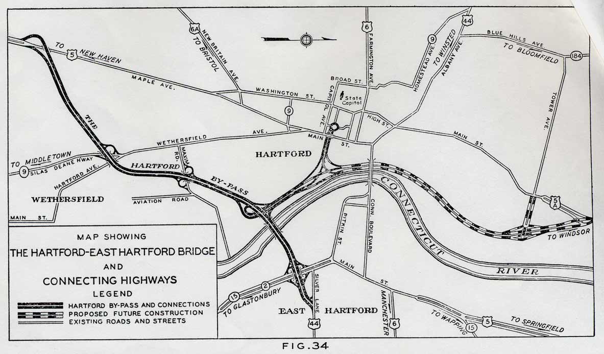
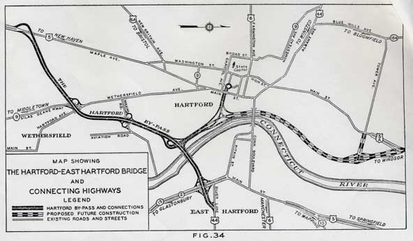 Proposed Charter Oak Bridge and connections, circa 1942. North is to the right. (larger picture (98K))
The Charter Oak Bridge connected to the first expressways in the Hartford area, and the first in the state other than the Merritt Parkway. The "Hartford By-pass", now Route 15 between the Berlin Turnpike and the Bridge approaches, also opened in 1942. The Conland Highway, now parts of Interstate 91 and SR 598 (the Whitehead Highway, once intended for I-484) between the Bridge approach and Pulaski Circle, opened in late 1945, delayed by World War II.
When it opened in 1942, the Hartford - East Hartford Bridge (it wasn't named the Charter Oak until later) was the longest span continuous plate girder bridge in the country. I'm not sure how competitive so precise a category had been, but I do have some figures for the original bridge:
The entire bridge, including metal railings and narrow metal divider, was painted a brilliant dark blue. (I wish I had taken a picture or two.) Cast iron ornamental medallions were incorporated in the railings. Toll booths (both directions) were installed on the East Hartford side, just west of a cloverleaf at Main Street.
In 1948, the designation of state Route 15 was changed, to include a continuous planned expressway, complete in many places, from Greenwich to Union. This included the Merritt Parkway, the Berlin Turnpike, and the Charter Oak Bridge, forming at the time Connecticut's most advanced, prominent highway. The bridge carries US 5 to this day along with Route 15, but also carried US 6 from 1943 to 1970.
When the Route 2 expressway opened around 1960, four ramps were added to connect to Route 15 just ahead of the toll station. They provided full access to Route 2 to and from the Bridge direction (but not to the northeast). Today only two direct connection ramps remain, from Route 15 northbound to Route 2 east and west; but before the bridge was replaced, there were mirror-image ramps across Route 15, guiding Route 2 traffic onto the bridge.
In the 1950s, three new bridges opened in the Hartford area: the State Street Bridge (now Founders Bridge), the Bissell Bridge (I-291), and the Putnam Bridge (Route 3). Like the Charter Oak, the Bissell and the Putnam charged a toll in both directions. But it was possible to use the free bridges and avoid the Charter Oak entirely.
"[The original Charter Oak] was a very beautiful bridge, but also a very dangerous bridge."
As traffic increased and the planned beltways (I-291 and I-491) were reduced in scope or cancelled entirely, the state paid particular attention to the overworked I-84/I-91 interchange and surrounding highways. What eventually came out of this was added responsibility for the Charter Oak: it would take over the 84/91 connections previously served by the Founders Bridge and two tight ramps to I-91. At the same time, the Charter Oak was showing its age, both in materials and roadway design.
After considering alternatives such as widening or adding a parallel span, the state decided to build a new bridge immediately to the south, and dismantle the old one. Work began in 1988 and the new bridge, free of tolls, opened to traffic on Aug. 8, 1991. The new bridge has a more modern, conventional look, with reinforced concrete and graceful support piers... but arguably not as much character as the old.
Interchanges at each end of the bridge were modified as well, primarily by eliminating ramps and simplifying traffic flow. The cloverleaf at Main Street in East Hartford, one of the first in the state, was changed into four ramps involving an extended Silver Lane. Two ramps from Route 2 were eliminated, as well as connections to and from I-91 to the north.
Now the Charter Oak Bridge is the only way from I-91 north to I-84 east, and I-84 west to I-91 south. But it's free, it's the newest bridge in the area, and driving southbound gives you a good view of the Hartford skyline, without getting stuck in I-84 traffic.