In the early 1900s, the state started taking over maintenance of major roads, and marked the Route 2 corridor with colored bands on poles: blue between East Hartford and Glastonbury, and yellow from there to Stonington. In March 1920, Connecticut awarded a $1.4 million contract to pave a 32-mile highway between Hartford and New London by way of Glastonbury and Colchester. The 18-foot wide concrete road eventually became parts of Route 2 and Route 85.
In 1922, what would later be Route 2 became part of NE-17,
a 120-mile New England interstate route entering at North Canaan and ending at Stonington. There was also an NE-2 at the time, which was renumbered US 5 in 1926. In 1932, NE-17 was decommissioned and Route 2 was born.
Early Realignments
(Details: see "Drive It", below.)
In the 1930s, Route 2 followed Main Street directly into the North Stonington town center. By 1943, a 2-lane bypass to the south had been built. Today, it looks like a natural part of the highway. The western end of this bypass meets Main Street where Mystic Road (old Route 119) also intersects.
Curiously enough, from 1947 to 1962, Route 119 officially crossed Route 2 at this point, continued along Main Street into North Stonington, and then ended at Route 2 about a mile to the east.
East Hartford - Glastonbury Expressway
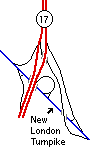
5-ramp interchange, Glastonbury
In 1952 and 1953, the East Hartford - Glastonbury Expressway ("EHG") opened; this survives today as Route 2 south to exit 7, and Route 17 to the freeway's end south of Hubbard Street. At that time, Route 2 exited the freeway going southeast at the 5-ramp New London Turnpike interchange (right). The original Expressway north end terminated at Main Street just south of Brewer Street in East Hartford.
Freeway plans
In the 1950s, shore traffic was turning Route 2 into a parking lot; before all parts of the Route 2 freeway were open, backups of 12 miles were not unknown.
In the mid-1950s, plans were in motion for a new freeway extending from Glastonbury to New London. The highway would also pass through Marlborough, Colchester, Salem, Montville, and Waterford, paralleling routes 2 and 85 in those towns. In December 1958 a detailed improvement proposal was presented to the state, and Route 2 to Colchester was later constructed with only a few variations from the plan.
The existing EHG would be widened to six lanes between the planned Interstate 491 interchange (now Route 3) and House Street; at that point, a new Route 2 freeway would branch off to the southeast, just as it does today.
After leaving the EHG, the new freeway would widen its profile to 100 feet between roadway center lines, with separate vertical alignments as needed to follow the hilly terrain. At the "elbow" south of Neipsic Road where Route 2 turns south, provision would be made for an interchange with relocated Route 83. (The report doesn't say whether the new 83 would be a freeway; in the 1960s, a Route 83 freeway was contemplated).
The planned Route 2 would connect with the recently (late 1950s) constructed two-lane section in the Ten Curves area near the Glastonbury - Marlborough border. New eastbound lanes would be built, while the existing two-way road would be converted to westbound lanes.
In Marlborough is where the built Route 2 differed the most from the planned. The 1958 plan called for raising the westbound roadway above Route 66 and Johnson Road, while running the eastbound lanes below. The report claimed this treatment would be less expensive and allow better ramp design at Route 66 (then called US 6A). The built Route 2 underpasses both roads in both directions.
In Colchester, work was underway in 1958 on a new two-lane section of Route 2. The new freeway would again get new eastbound lanes while using the two-lane section for westbound travel. East of Route 16, the freeway would turn south (along today's Route 11) toward New London. Provision for a relocated Route 2 freeway to Norwich (to be built later) was included at Colchester.
In 1963, the state articulated plans for extending Route 2 beyond Norwich to the shoreline at Stonington.
More plans in Colchester
The partial interchange at Route 11 was conceived in the early 1960s as a complete interchange, with only the left exit from Route 2 westbound deferred until traffic increased. In a 1960 local public hearing, the highway department said it expected to start construction on Route 2 in summer 1962, with most of Colchester's Route 2 open to traffic in 1964.
Building Route 2
In the late 1950s and 1960s, Route 2 was upgraded to a freeway in stages. "Super 2" sections of two-lane undivided road (but controlled access) were built between East Glastonbury and Marlborough, and Marlborough and Colchester. ("Super 2" is a nickname for any road built that way -- not an honorific for Route 2.)
The westbound lanes in Colchester are older than the eastbound lands. These segments bypassed hazardous conditions on the old Route 2, and were built with an expansion to four lanes in mind: the primary limitation was funding.
Freeway opening dates (some approximate) from west to east:
- Founders Bridge: Dec. 23, 1957 (reconstructed 1999)
- Mixmaster, East Hartford: Oct. 1965
- Pitkin Street to Main Street (exit 5A): 2.2 miles, Sept. 1, 1961, 10:00 am
- Main Street to Route 17: Nov. 21, 1952
- Route 17 to West Road, Marlborough: Oct. 15, 1964. Portions were only 2 lanes wide, though.
- West Road to Route 66: 1966
- Route 66 to South Main St (exit 15): 1964
- South Main St to Prospect Hill Road (near exit 17), Colchester: 2 lanes built c. 1959; widened c. 1967
- Exit 17 to Route 354: May 25, 1967
- Route 354 to Scott Hill Road (near Lebanon/Bozrah town line): Sept. 23, 1971
- Scott Hill Road to Route 32, Fitchville: Sept, 24, 1961
- Route 32 to Route 169: August 10, 1959
- Foxwoods "Super 4": summer 2009
"Loop 2" in Marlborough
In the 1960s to early 1970s, former Route 2 in Marlborough had a strange designation: Loop 2. There were signs for this, and a few citations in the Hartford Courant. I know of no other "Loop X" usage in the state. Oddly enough, the partial diamond interchanges at exit 12 and exit 15 prevented the motorist from making a loop with Route 2 without backtracking.
Plans East of Norwich
Proposed Route 2 freeway in Norwich, shown in 1972 official state highway map
Long-range plans in the 1960s called for the Route 2 freeway to be extended from Norwich to near the Rhode Island state line in Stonington. This would connect to other planned freeways in the area, including Route 2A and another one following Route 117 and Route 164. This network of freeways was never built, but sharply increased tourist traffic in the area revived plans for Route 2 and 2A multilane bypasses in the late 1990s. (More on this follows.)
In 1969, Route 2 was proposed to continue east from its terminus at Route 169, then gradually veer southeast toward Stonington.
The 1972 state map shows a different plan (see figure): Route 2 would loop around Norwich to the west, starting east of I-395 and rejoin the existing Route 2 south of the city.
In 1967, a public hearing was held in Stonington for the relocation of Route 2 from I-95 to the state line. Between then and 1970, the state renumbered this proposal to Route 78, to avoid confusion with existing Route 2. Route 78 was partially completed in 1979.
Improving Route 2
In 1975, the state's Suggested Improvements Program included a major widening of Route 2 from Main Street (exit 5A) to Route 94 (exit 8), echoing what was proposed in 1958 but never completed. The total cost was $6.6 million, and most of the work was projected to start after 1978. This was never done, but the opening of the Route 3 interchange led to the construction of auxiliary lanes (circa 1990) between Routes 3 and 17, making Route 2 six lanes in that area.
The 1975 program also called for revamping the outdated interchange and at-grade crossing at Fitchville; this was completed in July 2001.
September 1, 1987 saw the opening of the long-awaited interchange with Route 3 in Glastonbury. Route 3 was originally to have been part of Interstate 491, a southeastern bypass of Hartford.
On Feb. 23, 1994, the on-ramp to westbound I-84 was shifted from a left entrance to a right entrance, on the Bulkeley Bridge approach. The Mixmaster now has one fewer left entrance ramp.
Until July 2001, the interchange area at Route 32 at Fitchville, dating back to 1961, remained substandard, with thru traffic narrowing to single lanes, and an at-grade crossing with Yantic Lane. The state undertook a $25 million project to rebuild the interchange, removing the at-grade crossing, widening Route 2 to four lanes throughout, and replacing the incomplete 2/32 interchange with a complete split diamond interchange.
On July 4, 2001 (a good month for the highway), the project to widen Route 2 to four lanes between I-95 and Route 78 was completed. This was done to relieve congestion between those two highways, in place of an abandoned plan to connect 95 and 78 directly.
A "Super 4" at Foxwoods
In summer 2009, a long-planned improvement in Preston and Ledyard was completed, to help route thru traffic past the Foxwoods Casino. See my photos of this bypass on Flickr.
The 2001 Mashantucket proposal
The Mashantucket Pequot Indians, operators of the Foxwoods casino in Ledyard, proposed in August 2001 modifications to a one-mile stretch of Route 2 adjoining the casino. The proposal, which was not described in detail, includes "slightly relocating a portion of Route 2, building a cloverleaf and highway overpasses, adding a frontage road and creating four traffic roundabouts." The state traffic commission asked for more detailed drawings; state approval would be needed for any modifications to Route 2.
Officials from neighboring towns were perturbed at the secrecy surrounding the plan, which had been in the works for months. The tribe declined to comment further on the plan, saying it was one of several options they were considering for Route 2. The Mashantuckets had previously pledged $7.5 million of road improvements: certainly of a smaller scale than the relocation plan.
The 2003 Mashantucket proposal
In April 2003, the Mashantucket Pequots announced a $100 million-plus plan to upgrade Foxwoods and Route 2. An elevated 1.8-mile bypass, two or four lanes wide, would be created on tribal-owned land, from the Preston town line into North Stonington, where the tribe was building two golf courses. Visitors would access the casino via frontage roads and a flyover from Route 2. The existing Route 2 would be converted to an internal road.
What was done
In summer 2009, the bypass opened. It is a four-lane undivided freeway ("Super 4") with access only at two interchanges: a modified diamond at MGM Grand Drive, and a folded trumpet at Route 214. The ramp from Route 2 eastbound to Route 214, normally a direct diagonal ramp, instead passes over Route 2 to join the loop ramp from Route 2 westbound, because of space constraints. An opening ceremony was held in June 2009, when the eastbound lanes were opened; the westbound lanes opened about a month later.
On November 30, 2011, much of old Route 2, from the MGM Grand Boulevard westbound exit ramp along Foxwoods Boulevard to the eastbound Route 2 onramp, got a new designation: SR 680.


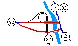 Interesting grade-separated intersection with routes 32 and 82 in Norwich.