Today's Route 17 is the third highway to use that number. The first was one of Connecticut's longest routes in-state; the second lasted only a year before being redesignated.
New England Interstate 17
In the 1920s, the number 17 was used for New England Interstate Route 17, which crossed the state along today's US 44 and Route 2 from northwest to southeast. The route was 117 miles long, with 103 miles inside Connecticut.
(Meanwhile, the modern route 17 was numbered like this: State Highway 104, Glastonbury to Portland; SH 112, Middletown to Durham; and SH 114, Durham to New Haven.)
Route 17, Old Saybrook to Granby (number changed before signing)
In late 1931, during planning for the 1932 route renumbering, the state originally planned to have the old Route 9 from Old Saybrook to Granby, including parts of today's Route 154, Route 99, and Route 189, as Route 17 instead of Route 9. On Jan. 1, 1932, the state marked this as Route 9 instead.
In 1932, NE-17 was disbanded, the 1931 Route 17 was not used, and the number 17 went into retirement for a while.
Route 17, Essex and Deep River
In 1939, a short-lived Route 17 was designated along Warsaw Street in Deep River and Main Street in Essex, as a connector from Route 80 to Route 9. This 3.28-mile route is SR 602 today. In May 1940, the state moved the eastern end of Route 80 from Deep River to US 1 in Old Saybrook, to help motorists use an inland alternative east of New Haven to congested US 1. The rerouted Route 80 replaced the one-year-old Route 17 in its entirety. (In 1966, Route 80 was moved back to its original terminus in Deep River.)
Modern Route 17
Today's Route 17 was created as part of Route 15. The section of today's Route 17 paralleling Route 17A was not numbered at first, then became (partially) Route 15A. In 1939, the state rearranged routes 15 and 15A so that 15 matched today's 17 and 15A matched today's 17A.
In the late 1940s, Connecticut mulled over how to make its connected highways from Greenwich to Union easier to follow (there were currently eight named highways, including the Merritt Parkway). On May 1, 1948, these roads were christened Route 15, and the leftovers (37.98 miles, from US 1 in New Haven to Route 2 in Glastonbury) became Route 17.
Northern Freeway - Glastonbury
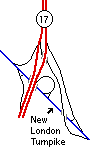
The northern Route 17 freeway includes a half-diamond interchange at Hubbard Street, a 5-ramp interchange at New London Turnpike, and half-interchange at Route 2.
In 1952 and 1953, the East Hartford - Glastonbury Expressway opened, from Main Street in Glastonbury to Brewer Street in Hartford. You'll recognize this today as the narrow part of Route 2 and the northern freeway portion of Route 17, which was shifted there from Main Street when the expressway opened.
The portion from New London Turnpike north was used by Route 2 until 1964, when the Route 2 freeway east of there opened. The sweeping 5-ramp interchange at New London Turnpike is a legacy of that era. In 1957 the state installed an overhead sign (experimental at the time) over the southbound lanes, designating the Route 2 and Route 17 directions.
In 1960, Glastonbury state senators requested additional ramps to allow access to and from Route 94 and Route 17 to the south. Given the short distance to the New London Turnpike interchange, this might have been a tough sell; and the ramps were never added.
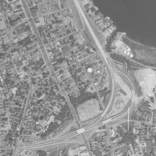
This aerial photo from 1957 shows the original Acheson Drive (Routes 9 and 17) before Route 9 was extended in 1959.
Southern Freeway - Middletown
The southern Route 17 freeway includes a diamond interchange at Main Street Extension, and a 3-ramp interchange at Route 9. As it turns out, this freeway wasn't really built for Route 17.
In the 1940s, traffic on Route 9 through Middletown (Main Street) was heavy enough that the state planned for an improved route along the river. On Sept. 15, 1950, Acheson Drive opened to traffic. This included the four-lane boulevard part of Route 9 and a short 9/17 freeway, with space left for a future leg of Route 9 toward Old Saybrook (see photo above). The Route 17 portion was merely part of the original bypass, and not the intent for a near-future freeway extension.
(A 1952 Hartford Courant article notes that the Route 17 portion was under construction and not yet open.)
The west end of the short Route 17 freeway at South Main Street was originally a rotary; this was changed to a T-intersection later.
Unbuilt Freeway - entire length
Even though the two bits of Route 17 freeway were really parts of larger projects for intersecting highways (Route 2 and Route 9), the state did have 1960s plans for improving Route 17 itself.
In 1963, the state planned to connect Route 2 in Glastonbury to a Route 66 freeway in Portland, as a four-lane freeway slated for sometime after 1975 (a common phrase at that time probably closer to "way in the future" than any specific year).
In 1966, the state projected that by century's end, Route 17 between Glastonbury and Portland would have twice the traffic volume of US 7 between Danbury and New Milford, and should be upgraded to a freeway by then. However, the 2012 traffic logs show an average daily traffic (ADT) of 7,000 to 17,000 vehicles for Route 17 between South Glastonbury and Portland, and from 23,000 to 30,000 ADT for US 7 between Brookfield and New Milford: not all projections pan out.
An April 1967 "Long Range Proposals" map included the Glastonbury to Portland freeway, which would have run west of Main Street. However, the proposal died in the 1970s.
The 1968 "Plan for the Future" and "Expressway Test Plan" proposed another 17 freeway from Middletown to Durham; and South Central Connecticut Planning Region maps from the same era called for a new freeway following Routes 17, Route 22, and Route 100 from Durham to East Haven. If all these plans had come to fruition, Route 17 could have been a freeway for its entire length.
In 1969, the Mid-State Regional Planning Association proposed building the freeway in Portland and Glastonbury, and a new arterial on the Middletown side.
The long range plan of the State Highway Department envisions a Route 17 expressway in Portland with this route to be the major link in a north-south expressway grid along the eastern side of the Connecticut River. This Route 17 expressway in Portland, as sketched in their plan of development, would connect with the proposed relocation of Route 66.
On the western side of the River, Route 17 would be relocated to serve as a major north-south arterial connecting Middletown and Durham with the South-Central Region. It should be noted that the South Central Regional Planning Agency has suggested that Route 17 be relocated as an expressway in that Region, and this proposal only connects this expressway to relocated Route 6A [now Route 66]. The plan for Route 17 includes a Westfield connection, which would provide a direct connection to old Routes 6A and 72.
...the Route 17 west side-arterial is illustrated with the connector continuing north to connect with Route 72 now under construction. This west side connector is an important intraregional arterial, as it serves to form the Westfield and South Farms sections of Middletown, and also provides a west side bypass through the most highly urbanized area of the Region. Additionally, this west side bypass would be an important addition to the circulation pattern of the Region and supportthe pattern created by the proposed Middletown CBD loop and the construction of new route 66.
I-91 interchange revamp might be dead
The state was planning, in 1997, to upgrade the interchange with I-91 and Route 80; see that page for details.


 The 1971 state official map shows Route 17 designated on Main Street in East Hartford. Route 2 and 17 overlap from the Main Street interchange to the 2/17 split in Glastonbury. Was Route 17 signed on this portion? I don't know.