The Parkways
The nationally renowned Merritt Parkway opened in stages from 1938 to 1940 in Fairfield County. It was named after Stamford congressman Schuyler Merritt; the Wilbur Cross Parkway was named after the Connecticut Governor who endorsed building the Merritt in 1925.
The Wilbur Cross Parkway served as the northeastward extension of the Merritt, part of a plan to connect Fairfield County with Hartford and an eventual statewide expressway network. It opened in stages from 1941 to 1949.
The Berlin Turnpike
The state had planned to extend the Wilbur Cross Parkway as a controlled-access highway to Hartford, but this was never done. Instead the four-lane Berlin Turnpike filled that role, a divided highway with at-grade intersections and a few interchanges. In 1965, Interstate 91 opened to the east, providing Meriden to Hartford travel without traffic lights.
Hartford Area
The six-lane Charter Oak Bridge over the Connecticut River opened on September 5, 1942. An interchange at the Park River Highway, soon to be called the South Meadows Expressway, was delayed by War Production Board restrictions. The South Meadows Expressway opened in late 1945; its route included the current Conland-Whitehead Highway (SR 598/proposed I-484), I-91 south to the Charter Oak Bridge, and the Route 15 expressway southwest to the Berlin Turnpike.
On April 28, 1989, the Charter Oak Bridge tollbooths, the last remaining in Connecticut, were removed. It was arranged so that the last person paying a toll was the first person who had paid when the bridge opened 47 years earlier.
On August 8, 1991, the new Charter Oak Bridge opened; building a new one had been more worthwhile than retrofitting the old one or adding another span. The old bridge, a blue-painted steel structure, had some character; the new one sports a more conventional look, with fluted concrete supports.
The state saved metal decorative seals from the old bridge and integrated them into railings at the new riverside park on the Hartford side; unfortunately, these were eventually blowtorched off and stolen. Never overestimate human nature.
The state's 1975 Master Transportation Plan recommended adding an interchange at Folly Brook Blvd in Wethersfield, but this was never done.
Route Numbering Changes
In late 1931, as the state put together its 1932 route renumbering plan, there was no Route 15 planned. What became the original Route 15 – a route passing through New Haven, Durham, Middletown, Portland, Glastonbury, and East Hartford, to Union and the state line, was originally to be called Route 9. On Jan. 1, 1932, though, this route debuted as Route 15. Its original path, from south to north:
- today's Route 17, from New Haven to Middletown
- today's Route 17A in Portland
- today's Route 17 into Glastonbury, up to the freeway terminus
- Main Street in Glastonbury and East Hartford
- today's Route 30 to West Stafford
- today's Route 190 and Route 171 to the state line. Some parts of this route were erased by I-84 construction in the area.
The Berlin Turnpike and South Meadows Expressway, signed US 5 and Route 15 today, were just US 5. Both the Merritt and Wilbur Cross Parkways went without numbers until 1948, though the Merritt had the unposted legislative number 1A.
By 1947, the new (undivided) Wilbur Cross Highway to Massachusetts was called Route 15, and in 1943 Route 30 was created between Route 74 in Vernon and Route 20 (now Route 190).
At the same time, the Wilbur Cross highway was under construction in north central Connecticut, in preparation for a continuous divided highway route from New York to Massachusetts via Hartford. However, that route comprised eight different named highways. To help motorists navigate the route, the state decided to apply the 15 numbering to all eight roads.
On May 1, 1948, Route 15 was reassigned to the parkways, Berlin Turnpike, South Meadows Expressway, and Charter Oak Bridge, as well as the existing Wilbur Cross Highway. The total length was over 116 miles, the longest of any state highway within Connecticut. The remaining portions of the old Route 15 were renamed Route 17. For about a year, the Wilbur Cross was not yet finished between Routes 34 and 10, and Route 15 was temporarily routed along New Haven city streets.
For about 3 decades after the 1948 extension, Route 15 was the way from Hartford to Sturbridge and the Massachusetts Turnpike toward Boston. (The highway continued across the state line as MA 15.) When I-84 was assigned to the Wilbur Cross Highway from East Hartford to Sturbridge, Route 15 kept its signing there as well.
On October 1, 1980, ConnDOT decided to truncate Route 15 at I-84 exit 57 (where it ends today), eliminating the overlap. Commissioner Art Powers explained that the move was intended to simplify signing and reduce confusion. Coincidentally, Interstate 84 (then called I-86) was under complete reconstruction for the entire length of its overlap with Route 15.
Steel-grate Sikorsky Bridge replaced
The original Sikorsky bridge, an 1,800-foot open-grate structure crossing the Housatonic River at the Merritt-Wilbur Cross transition, opened in September 1940. The steel grate was unpopular with drivers. An obscure urban legend (or "suburban legend") is the idea that the steel grate was mistakenly designed or installed upside down; but there's no truth to that.
In December 1998, the state put to bid a project to replace the bridge, with a six-lane structure (four thru and two operational) including a bike path/walkway on the north side.
The primary reason for replacing the bridge was the eroding steel in the support structure. In Nov. 2003, a ConnDOT representative said the 1940 bridge was in "good shape, but functionally obsolete for the traffic it carries."
The $84 million project to replace the bridge completed around 2007.


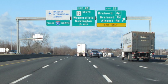 I-91 northbound, approaching the exit to Route 15 southbound in Hartford. US 5 overlaps with Route 15 here, but is not marked here.