Route 190 includes a short freeway (2 interchanges) between US 5 and a cloverleaf interchange at I-91 in Enfield. It continues easterly as a four-lane boulevard for a mile or so.

Updated Feb 3, 2025
 |
Route 190 includes a short freeway (2 interchanges) between US 5 and a cloverleaf interchange at I-91 in Enfield. It continues easterly as a four-lane boulevard for a mile or so.
An important east-west arterial route in northern Connecticut, Route 190 has a colorful history. The openings of two other freeways – one in Worcester, Mass. – led to changes in the route, and Route 190 itself was included in regional freeway plans. It intersects I-91 with one of the state's three remaining cloverleaf interchanges, and a short freeway section in Enfield hints at earlier, more ambitious plans for the route.
In the 1920s, today's Route 190 between US 5 and Route 32 was called State Highway 105; the portion east of that was SH 149. Around 1930 SH 105 absorbed SH 149.
In 1932, the original Route 190 was created, leading from Congamond, Mass. to Enfield, Conn., a total of 11.68 miles in Connecticut:
On July 3, 1961, the Bradley Airport Connector freeway to I-91 opened in Windsor Locks. Route 20 was assigned to the connector, and several area highways were rerouted, including Route 140 and Route 191. Route 190 was extended over former Route 20 through Somers and Stafford to I-84 in Union.
In 1963, as a result of the statewide Route Reclassification, Route 190 was extended eastward along Buckley Highway, at the time a town road, from I-84 to Route 171.
On Jan. 6, 1967, Route 190 was relocated to a new Enfield-Suffield bridge over the Connecticut River; a short freeway connection to I-91 was completed shortly afterward. The former Route 190 and bridge became SR 590. A few years later the old bridge was demolished, and SR 590 was turned over to local maintenance.
In 1973, a planned spur near Worcester, Mass. was given an interstate designation: I-190. This created an impending number conflict with state route 190, which crossed the Conn./Mass. border. In 1977, the segment of Route 190 west of Route 75 was changed in both states to Route 168. Interstate 190 was completed in 1983.
Route 190 was involved in several regional and statewide freeway studies. The most ambitious proposals included a complete freeway replacement, from the Granby area to I-84 in Union. Later plans included an eastward extension to Somers, and a westward extension to the vicinity of Bradley International Airport. The western extension was much more thoroughly studied and debated.
Route 190's original Connecticut River crossing was the Thompsonville Bridge, a narrow facility built in 1892. Between Thompsonville Rd. in Suffield and Main St. in Enfield, pilings of the old bridge are still visible. The bridge was substandard and hazardous, and in the 1950s the state studied how it might be replaced.
In Nov. 1958, the state unveiled a plan that was eventually built, in part, and survived into the 1970s. Starting at Route 20 and I-91, a relocated Route 190 would proceed west across a new bridge, then veer slightly southwest, to end at Bridge Street just west of Thrall Avenue. Route 190 would follow Bridge St. west to Route 75, where contemporary Route 190 (now Route 168) would continue west. (Bridge Street refers to another Connecticut River bridge, long gone, that I have no information on yet.) There was some opposition to the plan, though other Suffield residents and officials saw the value of reducing traffic along Thompsonville Road.
In Dec. 1958, a Suffield delegation suggested moving the western end of the new highway further south of the town center, heading toward Bradley International Airport. This would be a feature of several alternative corridors in future studies. Meanwhile, no change in the Enfield side (a straight connection to the bridge from I-91) was found to be practical.
In May 1961, survey work was to start soon on the $6.5 million project; but plans would change in the next few years.
In July 1961, a candidate for Suffield selectman disagreed with the plan to touch down at Bridge Street. He recommended extending the relocated Route 190 to corner of Route 187 (Sheldon and Grand Streets); and preferred that the highway have no at-grade intersections. Meanwhile, the Thompsonville Bridge was operating under a 10 mph speed limit and 7 ton weight limit.
In July 1962, the plan was changed. Route 190 would cross under Route 159 at Canal Road, which would be shifted south. A partial cloverleaf would be built on the west side of Route 159. Funds for this segment and the bridge were appropriated in 1961. Funds to extend Route 190 to Bridge Street would arrive in the future.
In April 1963, the scope of the project was pulled back. The projected cost, in state estimations, had risen about 20% from the original $6.5 million. To keep within that limit, the state planned to bid for work east of Route 159 only, including the bridge and the I-91 interchange.
In Feb. 1964, Granby planners understood Route 190 might be extended nearly straight westward, to connect with Mountain Road (called SR 822 at the time; now it's SR 539) in North Granby, parallel to a proposed Route 20 freeway. However, all other plans I've seen pointed Route 190 toward Bradley.
In Oct. 1965, a low bid of $2 million was received for the bridge.
On Jan. 6, 1967, the new bridge opened, and the old Thompsonville Bridge was closed to traffic. The Route 190 freeway segment was not complete yet, and would be delayed by a strike until later in the year. An eastbound detour off the bridge led drivers to the Pearl St. offramp, then east on Franklin St. The old Route 190 became SR 590, with the understanding that when Route 190 was complete in Suffield, SR 590 would revert to the town.
In 1968, a short (0.6 mile) section of Bridge Street easterly from Route 75 in Suffield was widened to 40 feet and christened SR 513. Not only was this done to handle increased area traffic near the new bridge, but it was intended to become part of Route 190.
In July 1971, the Thompsonville Bridge was being demolished. The first bridge at the site, an open structure of green timber, rotted away in 1810. A new bridge, 30 feet wide and 100 feet long, opened in 1826: the first toll bridge in northern Connecticut. The current steel bridge opened in 1893.
Meanwhile, the local upgrades would need to fit into wider long-range plans for Route 190. In 1961, the state's long-range plans included an expressway from Enfield to I-84 in Union in the Route 190 corridor, which was at the time called Route 20. At the same time, Route 190 would be an expressway from the Massachusetts state line (Congamond area) to the proposed Connecticut River bridge into Enfield.
In 1967, the Capitol Region Planning Agency (CRPA) proposed a Route 190 freeway leading from the Suffield-Enfield bridge, running north of existing Route 190, and ending in Somersville. Another CRPA proposed highway would extend or connect Route 190 to a Route 189 expressway west of Bradley International Airport.
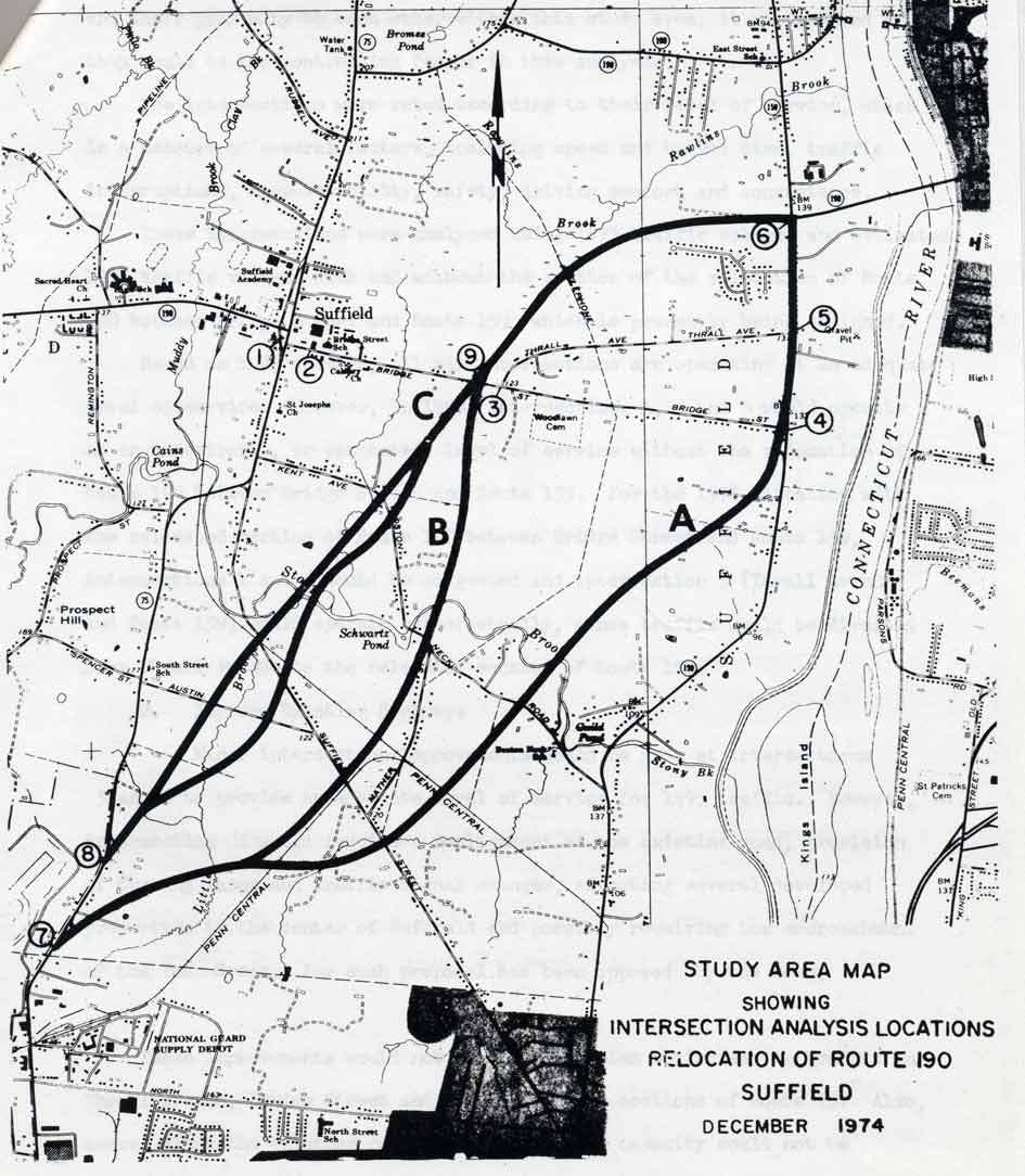
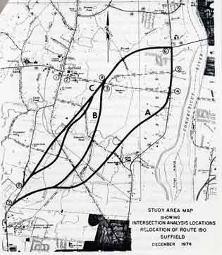 All Route 190 extension plans in the 1970s would bring the highway southwesterly, toward Route 75 and Bradley International Airport. Larger picture
West of the new bridge, Route 190 extension plans continued. In 1973, new corridor alternatives were discussed; each of them would travel southwesterly to meet Route 75 near the Windsor Locks border. The roadway's profile was eventually narrowed from a four-lane divided highway to a two-lane arterial.
In 1977 through 1979, plans were dusted off and some new alternatives explored. One plan, at $29.2 million, involved a new Connecticut River bridge at King's Corner, Enfield (near I-91 exit 46). Suffield officials favored this because it would relieve traffic from Route 159.
In 1984, Suffield officials proposed extending Route 190 to a planned Bradley International Airport ring road, connecting Route 20 to Route 75 around the north side of the airport. The ring road was not expected to be built for 5 to 8 years; to date nothing has been constructed.
In the early 1990s, the state and area towns mulled over a four-lane relocation of Route 190 to the airport area. These plans were put on the back burner, but in the late 1990s were revived by Suffield, which called for a four-lane bypass road to handle increased traffic from a Gov. Rowland-proposed $135 million Bradley International Airport upgrade.
From the Hartford Courant:
"The bypass would go from Route 20 in East Granby through mostly industrial and state prison land in Suffield to connect over a new bridge [about 2 miles south of Route 190] with I-91 in Enfield. The path of the bypass, south of Hale, Spencer, Austin and Mather Streets, would not impact any residential area."
In late 1997, the state was considering widening the Hazard Avenue section of Route 190 (east of I-91, in the Enfield business section) to four lanes eastbound. I haven't heard more on this, though.
A Route 190 Corridor Study was conducted in 1999-2000, covering the 10 miles between US 5 and the Somers-Stafford town line. Traffic is expected to increase 15 to 20 percent in the next 25 years, but an expressway is no longer planned: in fact, consultants and state officials said in December 2000 that large-scale widening will not be necessary.
Instead, more traffic signals and turning lanes, some redesigned intersections and some safety improvements are recommended.
Meetings were held in December 2000 to solicit ideas and comments from citizens and businesspeople in Enfield and Somers. One interesting idea heard was to extend Route 220 eastward to Routes 186 and 83 in Somers, to serve as a northern alternative to Route 190. The final public hearing was held in April 2002.
"The plan was to cross the river at CT 190. There were two other river crossings on the map (other than I-91), but one was out of the way, and the other wasn't labeled, so I doubt I would have been able to find it.
"CT 190 appeared to be a "normal" road on my AAA map. But when I approached the bridge, it had one of those boilerplate prohibition signs. I thought the sign was just a remnant of bridge discrimination past, and traffic was very light, so I rode across. As I rode across it, I could see on the other side that CT 190 appeared to be controlled access until the I-91 junction! Luckily, there was an exit to US 5 on the other side of the bridge.
"I used the "force" (i.e., lucky guess) to guide me which way to turn off US 5 to get back toward CT 190. Well it worked - I was back on CT 190, which was a "normal" road again."