The Mohegan Road, between New London and Norwich, was in 1792 the second turnpike completed in the U.S.
Route 32, which began life as New England Interstate NE-32, dates back to the early 1920s. Here's the original route:
- Military Highway, from US 1 in Groton to present-day Route 12. Before the 1932 renumbering, Route 32 was on the east side of the Thames, and Route 12 on the west.
- Today's Route 12 into Norwich.
- Today's Route 2 and 32 to Route 169 -- at an intersection long ago known as Harland's Corner.
- Town Street and West Town Street through Norwichtown (this is also old Route 2).
- Yantic Road and Old Route 32 into Franklin (there used to be a bridge across the Yantic River here)
- Today's Route 32 through Franklin.
- Old Windham Road and South Windham Road leading into Willimantic.
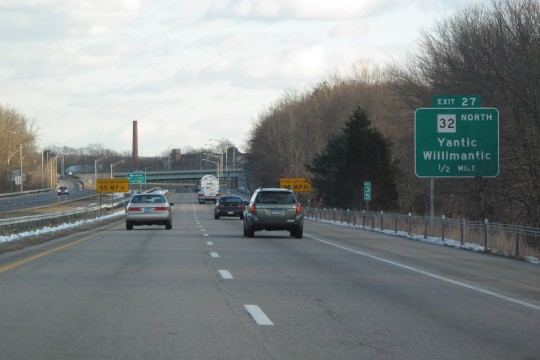
- Today's Route 32 through Willimantic.
- In Mansfield, north of Stearns Road, about 1/4 mile of old Route 32 is no longer open to traffic. The road was realigned around 1974.
- Today's Route 32 to Stafford Springs. Part of the River Road alignment was realigned in 1954 and 1967.
- Today's Route 19 into Massachusetts. Before the 1932 renumbering, the northernmost leg of today's Route 32 was known as State Highway 334. Across the state line, Massachusetts marked it as Route 32A.
In late 1931, when planning the 1932 route renumbering, the state still planned to mark Route 19 as part of Route 32. Monson Road would be Route 19. Since Routes 19 and 32 both cross the state line, both states likely agreed on swapping these to the layout we see today.
During the "Great Renumbering" of 1932, Route 32 was redefined to a route much closer to today's. In New London, Route 32 followed Williams Street and Old Norwich Road into Waterford (the four-lane section opened in 1940), and then today's Route 32 into Norwich. In Stafford, Route 19 was created from former Route 32, which was moved west to today's location.
4-lane Mohegan Avenue, New London and Waterford
The four-lane boulevard in New London and Waterford dates back to 1940. Before that, Route 32 followed Williams Street and Old Norwich Road, a stretch noted for steep hills and sharp curves. In the late 1930s, planning and design was done for a new, wider route closer to the Thames River, and in 1939 construction was well underway.
Route 32 was moved to the new section in 1940, and the former route became Route 32A, which was cancelled in 1943. Though the north end of the four-lane section coincides with the terminus of the Montville Connector (SR 693), the Route 32 widening predates the Connector by almost 20 years.
River Road, Stafford area
On Dec. 3, 1954, a new 0.8-mile section of Route 32 opened in Stafford, Ellington and Willington. The relocated 2-lane, $500,000 highway eliminated four curves, a grade crossing on the Central Vermont Railway and a one-way bridge over the Willimantic River. Portions of the old road alignment are still visible.
River Road, to the south
In late 1967, nearly 2 miles of Route 32 were relocated, south of the 1954 work. Old River Road is an old alignment.
South of Route 195
About a mile of Route 32 was straightened out south of Route 195; some time after 1963.
South Windham
Around 1939, Route 32 was relocated east of South Windham, to bypass a hazardous set of four right-angle turns with short sight distances. The old route, following Old Windham Road and South Windham Road, became Route 32A; in 1943, Route 32A was turned over to the town.
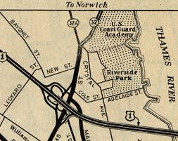
Relocation in Yantic
In the Yantic section of Norwich, Route 32 faced similar issues as in Stafford: a narrow bridge, this time over the Yantic River; a dangerous grade crossing with the pesky Central Vermont Railway, and congestion around the junction and overlap with Route 2.
In early 1954, the state Public Utilities Commission approved the construction of a new bridge over the railroad, as part of a Route 32 relocation in the area. (However, a 1937 newspaper article details the same approval given the state highway department by the PUC: to build a bridge carrying Route 32 over the railway.) A related project would create an interchange at Route 2.
State Highway Commissioner G. Albert Hill estimated the new highway would open in 1955. I don't have the exact date, but it's within a few years. Yantic Road in the area is part of old Route 32, as well as a road north of the river named "Old Route 32".
In August 1959, a freeway bypass of Norwichtown opened, carrying Route 2 and Route 32 from their split at Yantic to Route 169, at an intersection known as Harland's Corner. The interchange at Route 2 was an incomplete "Y", with the movement from Route 2 eastbound to Route 32 northbound missing; nearby were one-lane roadways for Route 2, and an at-grade intersection.
This area was improved in 2001: Route 2 is now four lanes throughout, with no at-grade intersections, and Route 32 meets it at a complete (though split) diamond interchange.
Route 32 freeway
In the 1960s, the state included a Route 32 freeway in its long range plans. In 1961, the proposed freeway would connect a US 6 freeway at Willimantic to a proposed Route 20 freeway in Stafford. US 6 was actually built there, intended for an eastward I-84 that was eventually scrapped. The Route 20 freeway was never built.
In 1962, the Tri-State Transportation Committee proposed a 44-mile freeway from I-95 in New London to I-84 in Willington.
In 1962, the State Highway Department Planning Division said:
Although it is anticipated that an expressway facility eventually may be needed to replace the present route, it will be many years before such a project could be given priority in relation to present statewide needs for expressways. A Route 32 expressway is not presently included in our long range thinking. Projected traffic volumes, based on the rate of growth over past years, indicate that in 1975 a two-lane highway would adequately carry the traffic over the major portion of this route within the limits of this study.
In 1963, the Route 20 plan was scaled back, and the north end of proposed Route 32 was truncated to I-84 in Willington. However, a southern segment to the freeway was added, connecting Willimantic to Norwich. The entire freeway was scheduled for "sometime after 1975", the horizon beyond which things were too cloudy to see.
In 1966 the state Interregional Planning Commission stated that a freeway was not needed in the immediate future, but should be added to the long-range plan. Among the many proposals, Route 32 was a low priority.
In 1967, Windham boosters and a Danielson state senator advocated a freeway route passing east of Willimantic, connecting I-84 to Route 2 at Yantic.
In 1969, area state representatives introduced a bill providing $45 million for construction.
In 1971, area representatives introduced a similar bill.
The idea of building a freeway at all appears to have been quietly dropped in the 1970s.
Four-laning along Thames River once planned
In 1969, the state General Assembly directed the highway commissioner to study the desirability of widening Route 32 between the Montville Connector (SR 693) and Route 82. This section was (and still is) two lanes wide.
The plans for the Route 2 freeway near downtown Norwich were in flux at the time, so the nearby relocation of Route 32 could not be studied. (Those plans were later cancelled.)
For the rest of the study area, the state concluded that, even though projected 1990 traffic volumes called for a four-lane Route 32:
- Existing Route 32 was in pretty good geometric shape
- The nearby Connecticut Turnpike (now I-395) was underused
- Expanding or realigning the right of way would affect hundreds of properties
... so that the cost and impact of major widening could not be justified.
Renumbering proposal opposed
A trip from New London to Willimantic could have simple directions: stay on Route 32 north. However, using I-395 instead to bypass downtown Norwich is often a better choice. To encourage this route, and relieve congestion in Norwich, the state proposed redesignating Route 32 around the city. By 1974, this had happened more than once, and each time merchants on local Route 32 pushed back, fearing that their highway would become a secondary route and be neglected. (About half the bypassed route is an overlap with Route 2, which would stay). In the 1974 proposal, Route 32 would follow Route 2A and Route 52 (now I-395) to reconnect with its original alignment at the 2/32 interchange with Route 52.
In 1976, the Southeastern Connecticut Regional Planning Agency (SCRPA) recommended designating part of New London Turnpike as Route 32, to encourage bypass traffic. That recommendation was not adopted.
Other changes considered
In 1966, Windham officials proposed a cloverleaf (likely some smaller interchange) at the intersection of Route 32 and former SR 601, connecting to a bridge across the Willimantic River that is no longer open to traffic. The "twisting, narrow" underpass was dangerous and congested. The cloverleaf was never built; traffic now uses the wider Frog Bridge to the west.
In 1972, Montville officials advocated building a cloverleaf at Route 52 and 32, at the entrance to the Mohegan-Pequot bridge. Exactly where the interchange would be (along Route 2A, presumably), and the details of the interchange, were not available. This was one of the highway projects scrapped by Governor Thomas Meskill.
Interchange revamp at I-95, with short freeway
Original Route 32 interchange at US 1.
The original Route 32 interchange at I-95 (shown at right) dates back to 1943, when the latter was a US 1 freeway. As traffic grew in the area through the 1950s and 1960s, capacity and safety problems with the interchange grew more apparent. At the same time, congestion on the Gold Star Bridge over the Thames River was getting intolerable; and in the 1960s, a plan for urban renewal in New London was taking hold. All three goals were addressed in a large highway project that completed on Nov. 1, 1974.
Another span was added to the Gold Star Bridge, expanding I-95 to five lanes in each direction across the Thames River. At the same time, about two miles of freeway were constructed for Route 32, including a new direct interchange at I-95. Even though in practical terms it ends at I-95, Route 32 officially crosses I-95 to end at Crystal Avenue (SR 437).
Corridor Study, Mohegan Avenue, 2023
In response to known safety challenges, the Southeastern Connecticut Council of Governments (SCCOG), the City of New London, and ConnDOT studied the corridor of Route 32 (Mohegan Avenue Parkway) from Williams Street to Benham Avenue. The 1940s-era four-lane divided highway is decent for cars, but unappealing and unsafe for bicycles and pedestrians.
The recommended changes, which as of 2024 are not yet funded or scheduled, include a landscaped median, safer pedestrian crossings, and a shared use path on both sides of the Route 32. There is not a severe road diet here; four lanes would be maintained (though some right-turn lanes are removed) and the Williams Street grade separation would stay.


 On Route 2 eastbound approaching junction with Route 32 in the Yantic section of Norwich. This interchange was constructed in 1959 and rebuilt in 2001. This photo was taken in December 2009.
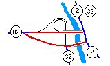 Interesting grade-separated intersection with routes 32 and 82 in Norwich.