Length 1,894.04 miles (111.57 miles in Connecticut)
FromUS 1 in Miami (New York state line at Greenwich)
To Canadian border near Houlton, ME (Rhode Island state line at North Stonington)
US 1 passes under I-95 (formerly the Connecticut Turnpike) in Darien. Photo taken April 2004 by Kurumi.
Hey, I-95, it's not us: it's you. Motorists just don't like you.
The big stories about I-95 include the planned widening, interchange modifications, and new bridge at New Haven; and a proposed widening to six lanes from Exit 54 in Branford to exit 92 in Stonington.
I-95 Profile
New York state line to East Haven: 6 lanes, plus operational lanes in some places
East Haven to Baldwin Bridge approach, Old Saybrook: four lanes
Baldwin Bridge: eight lanes (six thru lanes, and two operational lanes)
Old Lyme to New London: four lanes
Gold Star Bridge: nine lanes (six thru lanes)
Groton, to about Route 117: six lanes
Remainder to Rhode Island: four lanes
Other points of interest include a five-ramp interchange at the Sherwood Island Connector, and a cloverleaf at US 1 in Milford.
I-95 History
Most of I-95 opened as the Connecticut Turnpike in 1958. The New London section, east of I-395, opened in 1964. The route incorporates some 1940s improvements to US 1 as well. The Connecticut Turnpike was renamed the Gov. John Davis Lodge Turnpike when tolls were removed in 1985.
Relieving US 1
In the 1920s, auto and truck traffic were already snarling the Post Road (US 1), the only through route along the shoreline towns. Plans to bypass this route resulted in new inland routes in the 1930s (the Merritt Parkway in Fairfield County, Route 80 east of New Haven, and Route 84 (now Route 184) east of New London).
In Fairfield County, where the problem was most acute, highway commissioner John MacDonald in 1923 proposed three options for relieving the Post Road:
a parallel road for truck use only
a new road about 20 miles inland
improved Post Road with bypasses around congested areas
The Merritt Parkway, a variation of the second option, but about 8 miles inland, was completed in 1940. However, there would still be a need to serve commercial and passenger traffic closer to existing US 1.
Planning for I-95 and the Turnpike
In December 1944, the US 1 corridor was approved for an interstate route by the Bureau of Public Roads. In the same year, the State Highway Commissioner made public the route of a proposed express highway from the New York line to Westport -- nearly identical to the route taken by I-95 in that area today. (On August 14, 1957, the American Association of State Highway Officials (AASHO) approved the general routes for interstates 84, 91, and 95. On June 27, 1958, it approved the numbers.)
In 1947, the state legislature directed the highway commissioner to study the need and location of routes in the shoreline area. In 1953, they repealed the study act, and directed the commissioner to build an expressway from the New York state line to the Rhode Island state line.
Governor John Davis Lodge (1950-1954) helped push the turnpike through, even against the wishes of some well-heeled supporters in Fairfield County. The road, then named the "Greenwich - Killingly Expressway," was approved by the state in 1954. The issue helped derail Lodge's re-election bid; he lost to Abraham Ribicoff. The Norwalk Advocate reported: "In a tailspin after the loss, John had a nervous breakdown and received electric shock treatments, not uncommon at the time." The Turnpike was given his name in 1985.
The 7-State Highway proposal
In 1942, a group of state officials lobbied for federal help in building a 7-State Highway, through Virginia, Maryland, Delaware, New Jersey, New York, Connecticut, and Massachusetts. The road would have skirted Pennsylvania, and gone far enough inland to bypass Rhode Island; but otherwise, the 7-State Highway, though never built, was an ancestor to I-95.
The Cape Cod Expressway proposal
A sidenote to the Turnpike planning was a 1953 proposal from four state governors for a 260-mile "Cape Cod Expressway" from New York City to Provincetown, Mass. The highway would be part tolled, part free, and four to six lanes wide.
Although the Cape Cod Expressway was never completed, much of its planned corridor is now served by expressways: I-95 from New York to Rhode Island, and I-195 from Fall River to Wareham. The southern Providence bypass, along RI 138 and RI 24, was also planned as Interstate 895, which was cancelled. Most of the remaining US 6 route along the Cape is a Super 2.
Early improvements: Widening US 1
Before the Turnpike broke ground in 1954, the state had already improved US 1 in a few places; these freeway segments were incorporated into I-95.
In 1943, the New London-Groton Gold Star Bridge opened, along with a short segment of US 1 freeway on each side. There were interchanges at Route 32, Bridge Street, and Route 84 (now Route 184) at Route 12. Circa 1975 the New London part of this freeway, now I-95, was reconstructed to provide frontage roads, a better interchange with Route 32, and a new span for the Gold Star Bridge.
In 1948, the original Baldwin Bridge opened, with similar freeway approaches on each side, replacing a 1911 drawbridge. (The bridge was rebuilt and widened in 1993.)
US 1 had also been widened to a four-lane divided highway in Darien and East Haven before the Connecticut Turnpike was built. The four-lane Saltonstall Parkway in East Haven is evidence of this.
I-95 Opens
"Then not long ago, the ground shifted, for good I think. On a trip up I-95 north in Connecticut I realized there's a complete disconnect between Exit 76 and Exit 80. A whole block of missing exits, and not one sign to make note of it. Maybe this is how George Bush felt when no WMDs turned up in Iraq, disappointed, frustrated, then betrayed. I'd been had."
The Connecticut Turnpike officially opened January 2, 1958 for $464 million (though a small section in Byram was not open yet). The 89 miles along the shore (Greenwich to Waterford) became part of I-95; the remaining 40 miles had no signposted number until 1965. Now the remainder is signed I-395, except for the final elbow toward Rhode Island, which is unposted SR 695.
The remaining 16.6 mile section of I-95 to Rhode Island, not part of the Turnpike, opened December 12, 1964.
The Rise and Fall of Tollgates
The Turnpike opened with a barrier toll system to finance its bonds. Toll stations spanned all travel lanes in Greenwich, Norwalk, Westport, Stratford, West Haven, East Haven, Branford, Madison, Montville, and Plainfield.
The barrier toll system was already discouraged at the time compared to tollgates at exits. On the Massachusetts Turnpike, for example, the driver picks up a ticket on entry and pays the toll at exit; on I-95, all cross-state through traffic had to stop at six barriers.
The state's reasoning for barriers vs. exit gates: to serve the projected 75% of turnpike traffic that would be local. The reasoning for tolls vs. gas taxes or motor vehicle funds: the latter would not be sufficient to fund a nearly half-billion dollar highway. Another consequence of the barriers, after the fact: to help secure federal funds for interchanges between I-95 and US 7, and Route 8. As long as there were no barriers between the funded interchange and the next I-95 interchange in either direction, so the driver could exit I-95 without paying a toll, the funds would be available. In a 1966 hearing before Congress, state highway department representatives stated that an astute driver could travel I-95 for free, reading the "last exit before toll" signs and following trailblazers back to the highway past the barrier.
The bonds for the turnpike were to have been retired on January 1, 1997. However, the state stopped collecting tolls on October 9, 1985. Adding to the unpopularity of the tolls was a fatal 1983 accident at the Stratford booths, where a runaway truck struck a line of waiting cars, killing 7 persons. After tolls were removed, traffic increased about 20%.
In late 2001, the state floated the idea of reviving tolls on several highways; but this is proving controversial.
The Mianus Bridge Collapse
On June 28, 1983, the bridge over Mianus River in Greenwich collapsed; three people died as their vehicles fell 70 feet to the ground. The bridge reopened a month later, but the incident highlighted Connecticut's failing infrastructure and inadequate maintenance program. Governor O'Neill instituted a 10-year, $6.56 billion rehabilitation program funded by a gas tax to fix and resurface bridges and roads. Bond authorizations, only $8 million in 1980, jumped to $193 million in 1985, the first year of the plan. Traffic cones sprouted like weeds.
In the next 10 years, the state also completed some freeway gaps, namely Route 3 in Glastonbury and Wethersfield, Route 8 in Beacon Falls, Route 9 from Cromwell to West Hartford, I-384, and I-691.
Until the Mianus Bridge re-opened, traffic was diverted onto local streets, causing severe congestion. Northbound traffic exited on a temporary ramp to River Road, and continued to US 1 to rejoin I-95 at exit 5.
Unsnarling I-95
Interstate 95 is one of the nation's most congested highways. High population, urbanization, the funneling effect of Long Island sound, and dozens of closely-spaced interchanges contribute to the problem.
High property values and little "buffer room" to expand the right-of-way make the typical approach -- adding lanes -- extremely expensive.
In the 1980s, traffic engineers proposed alternatives for expanding capacity: widening to 12 lanes between Norwalk and Bridgeport, and 10 lanes elsewhere; double-decking the freeway (for 40 miles!); building a third freeway paralleling I-95 and Route 15; widening Route 15 (the Merritt Parkway) to 8 lanes; and running a monorail down the Merritt's median. If you were governor, and running for re-election, which would you choose?
More on the Decking Alternative
Double-decking -- placing one direction of a highway directly above the other -- is a way to build more lanes in less right-of-way than two roadways side by side. The drawbacks include cost, aesthetics, and seismic risk (but the latter is less of an issue in Connecticut than, say, Oakland, Calif., where a stretch of decked Interstate 880 collapsed in 1989).
Though there's significant opposition, decking seems to be the last resort that can never be ruled out for good. In late 2002, a poll by the Stamford Chamber of Commerce showed about 15% of respondents favored building a deck. Chamber President Jack Condlin said, "Things are so bad on the highway that people are willing to say, 'Go ahead, build a deck.'"
Evolution of I-95 Guide Signs
The "Big Green Signs," as guide signs are commonly known, were originally small and blue on the Connecticut Turnpike. Instead of nestled in route markers, connecting routes were announced in plain text: "U.S. 1," "CONN 135," and so on. On the I-395 section, I recall old green signs that still announced route numbers in text, such as "NORWICH / CONN 82 / NEXT RIGHT."
In the 1980s, Connecticut applied a "signing revision" to I-95 and I-395, replacing the old signs with "button copy": route numbers in white, surrounded by a hollow white marker. Route numbers were smaller and aesthetically challenged, and brought to mind Colorforms or childrens' stickers.
In 1999, the state has started replacing these signs with black route numbers on white markers for state and US routes.
"Fiery crash shuts down I-95"
On March 25, 2004, a traffic accident in Bridgeport reminded everyone how critical I-95 is to the area's transportation network. A tanker truck carrying 12,000 gallons of fuel oil collided with another vehicle and caught fire. The resulting blaze was hot enough to melt steel support beams on the southbound side of the newly constructed bridge over Howard Avenue.
I-95 had to be closed in both directions. Northbound traffic was directed over city streets. Southbound traffic was diverted onto Route 8 and then the Merritt Parkway (cars) or I-84 (trucks).
At first, officials said it would take weeks to repair the bridge and reopen I-95. However, the northbound lanes were repaired in three days, and on March 31, six days after the accident, a temporary bridge was in place on the southbound lanes, restoring I-95 traffic in both directions. Though the temporary bridge is strong and safe enough to last for years, it will eventually be replaced with a permanent bridge.
The quick response to this crisis has reflected well on ConnDOT; afterward, several truckers visited DOT headquarters to give their thanks for a fast restoration of service.
I-95 Future
The state is improving portions of I-95 in Fairfield County where space and funds permit. Adding a full travel lane or two in each direction throughout, though easily justified by traffic demands, is cost prohibitive for right-of-way needed.
The biggest projects in I-95's future are:
New Haven Harbor Crossing, aka Q-Bridge project, including a new 10-lane bridge, additional travel lanes, and a revamped I-95/I-91/Route 34 interchange. This has already started.
The Southeast widening proposal: widening to six lanes from Branford to Route 2, and modifying several interchanges.
Smaller projects, proposals and ideas include:
Auxiliary lanes in Bridgeport area
Sinking I-95 in New Haven's Sargent/Wharf area
New interchange with I-395 and completed Route 11
Reinstating tolls
Closing some interchanges
Harbor Crossing: the Q Bridge and the New Haven area
The 1950s vintage I-95 passing through New Haven, East Haven and Branford is choking on today's traffic. The six-lane Pearl Harbor Memorial Bridge over the Quinnipiac River (aka the "Q Bridge"), the antiquated Mixmaster interchange at I-91 and Route 34, and the narrowing to four lanes in East Haven all cause traffic snarls.
I-95 was designed in the area for about 40,000 vehicles daily; the average traffic today is more than three times that many.
Several projects, extending until 2016, will modernize I-95 here.
Build a new 10-lane Q Bridge, with a unique extradosed cable-stayed design
Modernize the 95/91/34 interchange, eliminating left exits and providing dual-lane connections between interstates
Combine exits 49 and 50
Widen I-95 to eight lanes from the new bridge to the frontage roads
Widen I-95 to six lanes beyond, extending to exit 54
In 1989, ConnDOT and the Federal Highway administration started studying alternatives. An early plan unveiled in January 1992 called for widening the bridge to 14 lanes; the unpopular proposal would have displaced 25 businesses and nine factories. That plan was withdrawn a few months later.
In 1993, the options ranged from doing nothing to building a 10-lane bridge. The state eventually moved forward with the 10-lane bridge.
The state also announced that Exit 46 (Sargent/Long Wharf Drives) would see minor changes; and in the DOT's words, "In response to strong local support the entrance ramp to I-95 north from Wooster Street will be retained." (However, in June 2000, it was stated that the Wooster Street ramp would be closed.)
In late 1999, the state revised the plan to make I-95 eight lanes instead of six in East Haven and Branford.
In early 2001, city and state officials pushed for a "signature" design for the bridge: an elegant cable-stayed system, with two masts supporting a fan of cables secured between the roadways.
In Nov. 2001, a project to widen I-95 to six lanes between Lake Saltonstall and exit 54 went to bid. On November 25, 2003, a third lane was opened northbound here.
In October 2003, work started on widening I-95 to six lanes between exits 48 and 51 in New Haven and East Haven. This $42 million project finished around late 2005.
Mixmaster interchange to be revamped in 2014
One of the final phases of the massive I-95 improvements in New Haven is a revamp of the interchange between I-95, I-91 and Route 34. The 1960s-era structure suffers from left exits, insufficient through lanes on I-95, and other safety and capacity problems. The state plans to modernize the interchange while retaining full access between all three freeways.
I-95 / I-91 / CT 34: Before and After
Before and after aerial photos (the second one simulated) show the changes proposed for the Mixmaster. All ramps are to and from the right, with greater width and higher turning radii. Ramps to and from Brewery Street are eliminated. Photos by ConnDOT; see I-95 New Haven site.
The state has long-term plans to widen I-95 to six lanes from Exit 54 (Cedar St., Branford) to Exit 92 (Route 2, Stonington). The cost would be about $1.6 billion. I-95 to the west (I mean, south) will be widened as part of the Q-Bridge project.
The remainder of I-95 east (north) of Route 2, while included in the original studies, was deemed not to need widening. The reason: in the design year (2525), this segment would still have an acceptable Level of Service (LOS) of B or C. The rest of I-95 would be mostly E and F.
The I-95 Southeast CT Feasibility Study in July 2004 issued a draft final report recommending the additional lanes and several interchange improvements. I'll have details of those after discussing the background leading to the study.
While I-95 west of New Haven is mostly heavily congested during rush hour, the highway east of New Haven is characterized by tourist and recreational traffic. Its highest congestion is from Friday through Sunday in the summer. I-95 is only four lanes wide in most locations here, and dates back to 1958 and 1964.
The Southeastern Connecticut Regional Planning Agency (RPA) had recommended widening I-95 to six lanes in the early 1980s. However, the state had many competing highway priorities that decade, and the proposal didn't go anywhere.
When the Foxwoods and Mohegan Sun casinos opened in 1992 and 1996, they changed the nature of traffic in the area and helped increase its visibility as a tourist destination. Recreational traffic increased greatly on I-95.
In 1999, the state completed a more general corridor study for southeast Connecticut. In 2002, a follow-on study was started, to examine one highway (I-95) in much more detail. The I-95 Southeast CT Feasibility Study draft final report was released in 2004.
The recommended improvements would be made in order of priority, with start dates from about 2008 to 2021. Major changes include:
Widen all four-lane portions to six lanes, from exit 54 in Branford to exit 92 (Route 2) in Stonington. The remainder of I-95 to Rhode Island would not be widened. ConnDOT had said earlier that widening to eight lanes, however desirable, would not be feasible.
Construct all widened portions to have 14-foot inside and outside shoulders, 12-foot travel lanes, and 10-foot concrete barrier median. This work would not be done on the Baldwin and Gold Star bridges because of expenses involved; and both bridges are close enough to standards currently.
Improve traffic at nearly every interchange with upgraded signals, added turning lanes, and so on.
Exit 60, Mungertown Rd, Madison: to this half-diamond interchange, add NB exit and SB entrance ramps at Wildwood Ave. to create a full diamond.
Exit 67 western half, Elm St, Old Saybrook: Add NB exit and SB entrance ramps to create a full diamond interchange.
Exit 67 eastern half, Route 154, Old Saybrook: remove NB 154 to SB I-95 ramp, and add SB exit and NB entrance ramps to create a full diamond. What's interesting here: Exit 67, which is now an "inside-out" split diamond, will become two complete diamond interchanges. Probably to become exits 67A and 67B. Or the Route 154 one could become exit 68. Also, a SPUI was considered here, but decided against for "operational and maintenance" reasons.
Exit 68, US 1 SB, Old Saybrook: eliminate this interchange, because of proximity to Route 9. Instead, reroute US 1 along Route 154 to use the upgraded Exit 67 East interchange to I-95. "Leftover" US 1 leading to exit 68 would be decommissioned.
Exit 69, Route 9: they considered replacing the trumpet interchange here with a high-speed directional interchange, but decided it was not feasible.
Exit 71 and 72, Four Mile River Road and Rocky Neck Connector: provide auxiliary lanes and braided "scissor" crossovers to eliminate weaving between the two closely-spaced interchanges.
Exit 76, I-395: the Route 11 project would widen I-95 and improve interchanges here.
Exit 82, Route 85: extend the New London frontage road system to just west of Route 85.
Rhode Island's long-term 2025 plans include widening I-95 from the Connecticut line to I-295, and also widen part of I-295. The I-95 portion is not congested, but planners cite comparatively low current costs and Connecticut's plan to widen I-95 as reasons for considering adding lanes. (However, Connecticut's widening would end at Route 2.)
Proposed interchange at Route 11 includes I-95/395 revamp
Proposed Route 11/I-95/I-395 Interchange
The proposed interchange for Route 11, I-95 and I-395 in Waterford. Access to US 1 is thrown in for I-95 and I-395. Note that the 95/395 interchange will still be incomplete, and no access is provided between Route 11 and I-395. However, I-95 and Route 11 will have high-speed access in all directions.
Route 11's proposed alignment has always included a touchdown at I-95 near the I-395 split at the Waterford - East Lyme border. In February 2002, ConnDOT revealed its proposed design for the interchange at a meeting of the Route 11 Advisory Board. The 3-level interchange would be about 70 feet high at its apex and handle movements between I-95, I-395, Route 11, and US 1. Its cost would be about $150 million -- over half that of the rest of Route 11.
In Nov. 2004, as part of I-95 improvement plans, Mohegan Tribe chief of staff Chuck Bunnell advocated adding a ramp to I-395 from I-95 southbound (and presumably the I-395 ramp back to I-95 north). The casino encourages visitors to stay on major highways, but those from points southeast have to use Route 32 from New London. If they miss the Montville Connector to get on I-395, they stay on Route 32, which narrows to two lanes, through Montville. Mayor Joseph Jaskiewicz agreed that this could be a problem, especially if a racetrack further north on I-395 is constructed as proposed.
Auxiliary lanes in Fairfield County
Though there's no room (at a reasonable cost) to add full travel lanes in Fairfield County, the state has been adding auxiliary lanes, aka speed change lanes, between interchanges in bottleneck areas:
southbound, exit 10 to exit 8, Darien and Stamford
both directions, exit 10 to exit 11, Darien
northbound, exit 11 to exit 12, Darien
northbound, Old Kings Hwy onramp to exit 13, Darien
southbound, exit 15 (US 7) to exit 14, Norwalk (under construction as of late 2012)
both directions, exit 15 to exit 16, Norwalk
both directions, exit 25 to exit 27A (Route 8 and Route 25), Bridgeport
both directions, exit 27A to exit 29, Bridgeport and Stratford
How about using breakdown lanes? (Please don't break down)
In October 2000, Gov. John Rowland suggested bringing breakdown lanes into service as travel lanes during rush hours. This involves more than signs and stripes: some shoulders would have to be widened, and possibly some emergency turnouts constructed. This plan has been used on parts of MA 128 and I-93 near Boston, but is discouraged by many highway professionals for safety reasons.
Gov. Jodi Rell, who assumed office in July 2004 when Rowland resigned, opposed using breakdown lanes, and the plan progressed no further.
Further work in Fairfield County
In 2000, five Transportation Investment Areas (TIA) were created so that traffic in those major corridors could be studied. The Coastal Corridor TIA includes I-95 and other roads in southwestern Connecticut.
In November 2002, the CCTIA board unveiled its 20-year strategic plan. The board opposes adding vehicular capacity to I-95; instead, it aims to mitigate traffic by expanding rail trips and creating barge feeder ports to help decrease truck trips.
However, the board does endorse studying operational and access improvements (similar to those underway), including the closure of some interchanges to decrease local traffic on I-95 if feasible. In addition, ramp metering and HOV lanes should be studied, the board said.
Truck use on I-95 is so heavy that the center lane on I-95 is said to be experiencing severe wear, because trucks are prohibited from the far left lane for most stretches along the highway.
New Haven - Long Wharf
In the late 1990s, the mayor of New Haven pushed for I-95 west of I-91 to be sunk below ground, part of a $450 million plan to improve access to the wharf from downtown. Opponents of the "Big Ditch" included developers of a planned nearby mall (the Galleria), who worry that drivers speeding along a walled-in canyon won't have reason to stop in New Haven.
Among a December 1998 study's recommendations for mitigating mall traffic:
Four new ramps, three off Route 34 and one going from Brewery Street to I-91.
Eliminate the Brewery Street on and off ramps.
Build a four- to five-lane road ringing the mall site composed of a reconfigured Sargent Drive and a new throughfare to be called Galleria Drive.
Expand a narrow road under Route 34 across from Union Avenue into a four- to five-lane street called Water Street Connector. The street will intersect with a widened Water Street and the mall ring road.
Move the southbound I-95 off-ramp further south so it's next to the on-ramp and facing the Church Street extension.
Lengthen and widen the northbound I-95 exit to Long Wharf so that it abuts the on ramp.
In early 2003, the state decided the best alternative was to keep I-95 at ground level, but widen to at least 9 lanes. Also under consideration: a pedestrian bridge over I-95, and relocating exit 46 (service roads) farther south.
Too many interchanges?
Several amateur highway designers, the author included, have tossed around the idea of eliminating or consolidating some of the 90-plus interchanges on I-95, especially in Fairfield County. At least one Connecticut lawmaker had the same idea.
In January 1999, a bill was introduced in the General Assembly to study the feasibility of closing some interchanges in Fairfield County. In January 2001, the DOT proposed closing seven onramps during rush hour for a six-month trial period, akin to very coarse ramp metering: no cars could enter at all from 6 to 9 a.m. and 3 to 6 p.m. The entrance ramps are at interchanges 4 (Greenwich); 10 and 12 (Darien); 21 and 23 (Fairfield); 31 (Stratford); and 35 (Milford). Most of the ramps are not heavily used, and many are very close to the next exit ramp, causing merging problems.
In June 2003, the state Transportation Strategy Board called for closing some I-95 ramps and possibly adding lanes. Which ramps? The board chairman, R. Nelson Griebel, is leaving that to ConnDOT and local governments. "In my more foolish days, I suggested that we (the strategy board) identify the ramps, and there was a huge conflagration," Griebel said in a New Haven Register story.
State lawmakers, however, criticized the strategy board for passing on controversial decisions. "They're tossing back to us all the tough issues," said prominent state Sen. William A. Aniskovich, who has taken at least one unpopular stand: widening the Merritt Parkway to six lanes.
In late 2004, Gov. Jodi Rell said she is not pursuing the closure of any interchanges.
Reinstating tolls discussed
Around the year 2000, long-range planning for Connecticut roads included the idea of adding or reinstating tolls on some highways. Such an idea has political problems, especially with memories of the 1983 tollbooth accident that claimed seven lives and led to tolls being removed from I-95.
However, newer technologies might be brought into play, including electronic transponders and peak travel time charges. In June 2003, the state Transportation Strategy Board passed a resolution supporting electronic tolls for peak-time motorists.
Value-priced lanes for I-95 southeast deemed not feasible
In the I-95 Branford to Rhode Island feasibility study, managed or value-priced lanes were studied. If this were adopted, each direction of the improved I-95 would have two general-purpose lanes and a third lane, separated by Jersey barriers, for which a variable fee would be charged by transponder. Access to and from the lane would be via slip ramps. The lane would not have its own ramps to crossing streets as HOV lanes on I-84 and I-91 do.
Adding value-priced lanes for I-95 southeast was judged substantially less effective than widening to three general-purpose lanes in each direction, for the following reasons:
Increased average delay (less traffic capacity)
Greater cost and environmental impact
Inability of user fees to pay for more than about 20% of added cost
I-95 More...
For some reason, exits 77-79, which should be near New London, are missing. Exit 80 follows exit 76 at the I-395 interchange.
Occasionally murmuring is heard about I-95's north/south signage when the highway runs mainly east-west in Connecticut. In fact, early signs for I-95 did say "East" and "West".
I-95 VMS hacked?
The comp.risks digest in 1993 (link) carried a report from WHJY, a Providence radio station, that the variable message signs on I-95 had been hacked.
"Sometime last week, electronic sign boards along Interstate 95 in Connecticut were hacked to say "You all suck." These boards are normally used to announce construction, fog, and whatnot. Apparently it was several hours before State Police and the Highway Department were able to clear the messages.
"Well, it happened again a day or two ago, with a different message attacking the Governor. A teenager has been caught; he said that there was no password on the Highway Department's computer system."
I haven't seen a more direct confirmation of this, but it's nonetheless a fun story.
I-395 vs I-95
Here's an excerpt from a WTNH-TV (Ch. 8, New Haven) interview about the politics of expanding I-95 compared to I-395 construction a quarter century earlier.
WENDY CICCHETTI / NEWS CHANNEL 8: "When you look at 395 it's hard to believe the state can't get the ball rolling to remedy the situation on 95, twenty years ago the state completed this vast stretch of highway that spans from waterford to putnam, and that was when connecticut's population was considerably less."
JAMES SULLIVAN: "i admit to you sometimes it is sparsely traveled."
SEN TOM UPSON / (R)-WATERBURY: "there's no question that Gov. John Dempsey from Putnam [Connecticut]...I'm sure he had something to do with it."
Ch. 8: The 61.8 Million dollar road was completed during governor John Dempsey's reign in the late 60's. State senator Tim Upson argues 395 is a prime example of the role politics plays in road construction. But for some reason he says no one wants to touch I-95. He introduced a bill to widen 95; it went nowhere.
SEN TOM UPSON: "When you have a major problem like 95 that is so monumental it is very disappointing we can't prioritize this highway."
Ch. 8: The DOT insists it all comes down to money, estimating the project would cost billions of dollars.
I-95 Sources
"New Connecticut River Bridge Formally Opened." The Day [New London, Conn.], Aug. 24, 1911.
"New England Road Project Backed." New York Times, Oct. 29, 1953. (c/o Steve Anderson)
"Relationship of Toll Facilities to the Federal-Aid Highway Program." US House of Representatives, Committee on Public Works, March and June, 1966.
"Regional Transportation Plan for Southeastern Connecticut." Southeastern Connecticut Regional Planning Association, 1983.
"Fallen CT Bridge Reopened." New York Times, July 23, 1983.
"A Promising Reversal On Highway Policy." Hartford Courant, May 15, 1992.
"Collapse Served as the Catalyst for Billions in Repairs Statewide." Hartford Courant, June 27, 1993.
"New book recounts the many lives of John Davis Lodge." Norwalk Advocate, Dec. 19, 1999.
"Four lane expansion considered for I-95" WTNH-TV, Sept. 4, 1999. (Referred by Steve Anderson)
"Designer chosen for new Q bridge" New Haven Register, Jan. 22, 2000.
"DOT To Perform $650 Million Of Improvements To Branford Area" Branford Sound, Mar. 27, 2000.
"Residents take look at plan to widen I-95 bridge." WTNH-TV [New Haven, Conn.], June 14, 2000. (Referred by Steve Anderson)
"Truckers want to use Merritt and Wilbur Cross parkways." Hartford Courant, Feb. 4, 2003.
"Board calls for ramp closures." Greenwich [Conn.] Time, June 11, 2003.
"Strategy board calls for studies on I-95 issues." New Haven Register, June 11, 2003.
"Fatal collapse of Mianus Bridge spurred changes." Associated Press, June 28, 2003.
"Long Road Ahead: Get ready for 10 years of I-95 construction woes." New Haven Register, July 20, 2003.
Enslin, Jon. "Re: 20th Anniversary of CT's Mianus River Bridge collapse passes." Post to misc.transport.road, Jul. 2, 2003.
State of Connecticut, Transportation Strategy Board, Coastal Corridor Transportation Investment Area board. "Twenty-Year Strategic Plan for Transportation in the Coastal Corridor Transportation Investment Area." Nov. 6, 2002.
"Second phase of I-95 work to begin." New Haven Register, Oct. 15, 2003.
Collins, David. "Pondering The Exit To Nowhere." The Day [New London, Conn.], Nov. 21, 2003.
"Fiery crash shuts down Interstate 95." Associated Press, Mar. 26, 2004.
"Southbound lanes of Interstate 95 in Connecticut reopen." Associated Press, Mar. 31, 2004.
Connecticut Department of Transportation. "Additional Travel Lane to Open on I-95 Northbound from Lake Saltonstall Bridge to Exit 54 November 25, 2003." Nov. 20, 2003.
Feasibility Study, I-95 Corridor, Branford to Rhode Island: Feasibility of Managed ("Value-Priced") Lanes. Prepared for Clough, Harbour & Associates LLP and ConnDOT, July 2004.
Clough, Harbour & Associates LLP. I-95 Corridor Feasibility Study - Final Report. Presented to ConnDOT, July 2004.
I-95 New Haven (ConnDOT): Information and photos concerning the planned I-95 improvements from West Haven to Branford, including a new 10-lane bridge over the Quinnipiac River and a modernized interchange at I-91 and Route 34.
Aerial photos (Greg Amy; Route 32 freeway interchange with I-95)


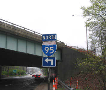 US 1 passes under I-95 (formerly the Connecticut Turnpike) in Darien. Photo taken April 2004 by Kurumi.
 Before and after aerial photos (the second one simulated) show the changes proposed for the Mixmaster. All ramps are to and from the right, with greater width and higher turning radii. Ramps to and from Brewery Street are eliminated. Photos by ConnDOT; see
 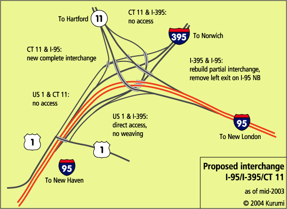 The proposed interchange for Route 11, I-95 and I-395 in Waterford. Access to US 1 is thrown in for I-95 and I-395. Note that the 95/395 interchange will still be incomplete, and no access is provided between Route 11 and I-395. However, I-95 and Route 11 will have high-speed access in all directions.