CT 8
  • Length 147 miles; 67.34 miles in Connecticut
  • From I-95 in Bridgeport
  • To VT 9 in Searsburg, VT

Route 8 has some nice scenery along the Naugatuck River, and serves some industrial towns whose glory days are behind them. In some Asian cultures, Route 8 is fortuitously numbered, though not as much as Route 88, or 888. (Where 8 sounds like "money" or "wealth", Route 4 sounds like "death", and is just about as unlucky.)

OK, enough numerology

Route 8 starts at a trumpet interchange with I-95, and overlaps with Route 25 in Bridgeport. Starting at four lanes, it gradually widens to 10 lanes at the 8/25 split. North of here Route 8 is primarily a four-lane freeway up to US 44. There's a graceful interchange with California-style flyovers at Route 15; and a not-so-graceful double-decked interchange (photos) at I-84 in Waterbury.

If some state and town officials have their way, Route 8 between Bridgeport and Waterbury could get an interstate designation, such as I-284 or I-595.

Traffic light trivia

Route 8 figured prominently in a trivia quiz by WVIT Channel 30, the state's NBC affiliate. The clues for "Where in Connecticut is [reporter] Brad Drazen" on Nov. 17, 2003:

* Thomas Sanford, who later sold his "recipe" for $10 to the Diamond Match Company, made the first friction matches here in 1834.

* In 1998 this town build Volunteer Park, the first point of public access to the Naugatuck River in the entire valley.

* The only traffic light on the original State Route 8 between Torrington and Bridgeport is right in the center of this Connecticut town

The answer: Beacon Falls, with the last segment of Route 8 to be upgraded to freeway. (However, I'm not convinced that no other segments of Old Route 8 in that interval have traffic lights; can you really drive on it through Seymour, Naugatuck and Waterbury without stopping?)

CT 8 History

Route 8 is one of the original New England Interstates, early 1920s 2-lane roads that crisscrossed New England and kept consistent numbering. It originally extended another 64 miles beyond Searsburg to VT 103 in East Wallingford, VT; most of this was taken over by VT 100 in the early 1960s.

Route 65

Old Route 8 and Route 65, Shelton to Stratford
Old Route 8, official CT map, 1949
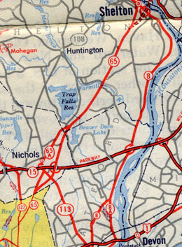
This 1949 map scan shows the historic alignments of routes 8 and 65 south of Shelton and Derby.

Route 8 originally ended in Stratford, not Bridgeport. In Shelton, the old Route 8 turned to follow present-day Route 110 and Route 113 to US 1. The section of Route 110 south of 113 was numbered Route 8A. The old pre-freeway Route 8 between Shelton and Bridgeport was called Route 65. (For more information, see "Drive the original Route 8," below.)

As plans developed to upgrade Route 8 to a freeway, its south end was relocated to downtown Bridgeport; this was done on Sept. 27, 1951, with Routes 110 and 113 moving close to where they are now, and Route 65 being retired. These changes were done, in the words of the highway commissioner, to simplify the numbering pattern in the area.

Building a freeway

The Route 8 freeway, planned since the 1940s, opened in sections over a period of 35 years. A four-lane at-grade segment in Beacon Falls and Naugatuck opened in 1942; this is now partly Route 42 and partly town-maintained.

On December 17, 1951, the Commodore Hull bridge over the Housatonic River opened, along with the first few miles of freeway in Derby. In January 1961, another three miles opened, from the Ansonia-Seymour line north.

On Nov. 23, 1964, two sections of Route 8 opened: 1.8 miles in Torrington from E. Main St. to Alvord Park Rd.; and 6.5 miles in Waterbury and Thomaston, from Huntingdon Ave. (exit 36) to Reynolds Bridge (exit 38).

The path of Route 8 through Waterbury reportedly would have required condemning of dozens of houses, displacing hundreds of people. But in August of 1955, a flood in the area destroyed most of the properties. Peter Rosa writes: "it probably saved the state millions of dollars!" The Waterbury section, along with a towering multilevel interchange with I-84, opened in 1967.

In 1970, the northernmost segment of freeway opened, between Pine Woods Road in Torrington and US 44 in Winsted.

A segment of Route 8 opened in Shelton in 1975, with $125 million in the transportation plan to convert 9 more miles to expressway. In the mid-1980s, the final segments opened: one surrounding a new interchange with Route 15 (the Merritt Parkway); and a stretch in Beacon Falls on June 1, 1982.

The newest segment of Route 8 freeway, in Beacon Falls, was started in summer 1979 and finished in 1982. The highway, which meanders along the Naugatuck river on a separate alignment for each roadway, was judged Superior in the 1984 FHWA highway design awards.

The Commodore Hull Bridge was rehabilitated in the late 1990s, as well as the interchange with Route 34. The interchange work began in 1995 and finished in 1997. The geometry of the 5-ramp interchange was mostly unchanged.

The state's 1963 plan included a link from Winsted to Colebrook to be completed in 1972; but this was never done, and the freeway ends in Winsted.

"Interstate 8?"

In 1962, the Tri-State Transportation Commission called for building the Route 8 expressway from Bridgeport to the Massachusetts state line. The Bay State planned an eventual connection to the Massachusetts Turnpike. In 1972, Massachusetts congressmen were pushing for interstate designation and funding for Route 8 up to Vermont. This didn't pan out. However, Waterbury officials plan to ask for interstate designation for Route 8 up to Waterbury.

CT 8 Drive it

Drive the original Route 8

To drive the original Route 8 (northbound), start at the corner of US 1 and Route 113 in Stratford. From its inception in 1922 or 1923 until its rerouting in 1951, Route 8 started here, not in Bridgeport.

Drive north on Route 113 until it ends shortly at Route 110. To the left, the old Route 8 continued; to the right, Route 8A reconnected with US 1. Turn left (north) onto Route 110.

For the next few miles, you will follow the west bank of the Housatonic River. The primary roadgeek point of interest is the interchange with Route 15, near the north end of the Merritt Parkway. The four-ramp interchange built in 1940 was upgraded to seven ramps in 1958 for increased capacity, then revised to five ramps again in 1998 for increased safety.

As you enter downtown Shelton, you'll pass under the existing Route 8 freeway, and soon encounter Bridgeport Avenue to the left. This road, now "secret" route SR 714, was the post-1952 routing of Route 8, until the freeway opened in the 1980s. At Bridge Street (appropriately), turn right and cross the Housatonic River. The Commodore Hull Bridge on modern Route 8 opened in 1951.

Once in Derby, turn right (east) on Route 34, then left again on Elizabeth Street. After proceeding north for about a mile, turn left (north) on Seymour Avenue. As you cross into Ansonia, the street becomes Wakelee Avenue, and merges with Route 334. Just after the interchange with Route 8, turn right on Lower Derby Road, which enters Seymour.

Lower Derby Road does end shortly afterward; the original road is not accessible at this point. Instead, use the entrance ramp to Route 8 north (exit 20) and get off at the next exit (Derby Avenue). You'll eventually reach Route 313 and Route 67. Turn right on Route 67, and left on North Main Street. In Beacon Falls, this road turns into South Main Street, then Old Turnpike. (I'm not absolutely certain of the original route between routes 67 and 42, but this one is the most likely).

Turn right on Route 42 and follow it toward Beacon Falls center. When Route 42 turns east, keep going north, on Main Street. This four-lane road was widened in 1942, and was the last section of Route 8 to be upgraded to a freeway, decades later. You'll need to use the next entrance to Route 8 north, since Main Street ends shortly afterward. The original roadbed is gone, replaced by the freeway.

The old Route 8 through Waterbury includes South Main St, West Main St, and Thomaston Avenue. You'll follow the east bank of the Naugatuck River while the modern Route 8 follows the west. Thomaston Road in Waterbury becomes Waterbury Road in Thomaston; Connecticut towns are often reciprocally polite that way.

As you enter Thomaston on Waterbury Road (SR 848), things start to get complicated. At an interchange with modern Route 8, the road becomes Route 254 and Main St. Continue ahead, but when 254 branches to the left, stay on Main St, which is now SR 807.

About 5 blocks later, Route 222 appears; take 222 north (North Main St) until you pass under Route 8 again. Shortly after that, Route 222 will fork right. Continue straight on Main St.

Main Street will dead end after that; park your car and continue walking in that direction, and you'll reach the Thomaston Dam; cross that and keep walking, and you'll reach Castle Bridge, which was closed some time back. Now you'll have to retrace your steps back to the car.

Drive back to Route 222 and get on Route 8 north. At the next exit (41), get off and turn right, crossing into Harwinton. When you reach Valley Road, turn right again; now you're going south on old Route 8. The road will end, and you can park, keep walking, and reach the other side of Castle Bridge. Return to your car.

Valley Road dead ends on its north side as well, at the village of Campville. If you walk north from there, you will eventually reach modern Route 8, which buried some of the older highway. The original Route 8 crossed the Naugatuck River back into Litchfield slightly north of Route 118.

Once you backtrack to exit 41, take Route 8 north to exit 42 and turn west on Route 118. Turn north on Thomaston Road (SR 800) and it's a fairly easy trip through Torrington to US 44 at Winsted on the same road. There, the freeway ends, and Route 8 continues as a two-lane road into Massachusetts.

In the Colebrook River Reservoir recreational site, there's a 7-mile segment of old Route 8, accessible only when water levels are low.

CT 8 Future

The state is studying the Route 8 corridor between Exit 11 and the Seymour-Beacon Falls town line, which includes the Ansonia-Shelton-Derby district. Current problems include "poor mainline alignment" (curves) and exits too close together, as well as underpowered interchanges that cause traffic backups. One study objective is to identify improvements and policies that will allow Route 8 to carry traffic volumes projected to the year 2020. A public information meeting concerning this was held in Derby on June 17, 1997.

In September 2000, ConnDOT presented the Route 8 Corridor Planning Study, proposing about $100 million in projects over the next 20 years along the highway. In general, they recommend longer entrance ramps (more room to accelerate to highway speeds) and some new frontage roads. More specifically, the study includes:

Not all changes are favored by the towns affected.

In late 2003, engineers presented the Valley Council of Governments, the area regional planning agency, with a five-year, $30 million package of planned improvements. The plans will be forwarded to ConnDOT. These are:

The Greater Bridgeport Valley Regional Planning Agency conducted a corridor study in the same area, and in October 2000 proposed consolidating some interchanges and lengthening some ramps. The higher priority items include:

Federal funds may be applied to the $8 million Howe Avenue ramp project, which would take about 3 years to design and build.

A study of I-84 in the Waterbury area includes a look at the "Mixmaster" interchange with Route 8. The interchange may require its own study later, because of the high cost and traffic disruption involved with replacing it.

In December 1998 the state planned to study a spur road from Route 8 serving the Bristol Business Center and the Plymouth Industrial Park, which could bring truck and business traffic off US 6. The hilly terrain presents a challenge.

Interstate designation sought

The State Transportation Strategy Board includes a committee studying the I-84 corridor. One of their recommendations for further investigation as of late 2001: would designating Route 8 as an interstate highway between I-95 and I-84 help Waterbury economically? The Waterbury Chamber of Commerce says yes, and considers the designation a legislative priority.

CT 8 Sources