Alignment changes - non-freeway
In the 1920s, most of today's Route 34 was called State Highway 117 (Newtown to Derby) and State Highway 145 (Derby to New Haven).
In 1932, Route 34 was commissioned. Its exact start in New Haven is not clear, but by Sherman Avenue it was following Derby Avenue westward out of the city. The original Route 34 continued through Derby and into Newtown as it does today.
At Sandy Hook, Route 34 intersected the old US 6 and overlapped with it to reach Newtown center. At that point, Route 34 followed today's Route 25 south to Route 302, and then routes 302 and 53 into downtown Danbury. A 1934 state map shows routes 34 and 58 overlapped as they terminate at US 6. The overall length of the route was about 34.6 miles.
In 1935, the new US 202 was designated, incorporating the Route 34 alignment between Newtown center and Danbury. Route 34 was truncated back to US 6 in Sandy Hook, resulting in a 22.6-mile route.
Derby Avenue four-lane section
In the late 1930s, traffic along Route 34 between Derby and New Haven was heavy enough to warrant improvements there. In 1940 Route 34 was widened to a four-lane divided highway, access partially controlled, between Route 115 and east of Route 122.
A few other highway segments in the state were also widened around this time: the Berlin Turnpike, Route 32, US 5 in South Windsor and others. But few such widenings have been done since the 1940s. Connecticut highways tend to be either undivided roads or freeways with full access control.
The Oak Street Connector
The freeway section of Route 34 in New Haven, leading directly to the "Mixmaster" interchange at Interstates 95 and 91, arose from a popular type of highway project in its era: build an expressway through the center of a city, and in passing, clear a blighted area. New Haven's Oak Street area was said to ply the "worst slum area in the city."
Planning for a highway link from the future Connecticut Turnpike to downtown New Haven and points west started in the late 1940s. The Oak Street Connector, and Oak Street Improvement Project, appear in the Short Approach Master Plan written by the City Plan Commission in 1953. This program had two phases: the Oak Street Connector terminating at York Street, and a continuation westward to the West Haven/Orange town line.
The state developed a plan for the first phase, and city mayor Richard C. Lee and staff suggested adding three exit ramps to help traffic flow into downtown. The state highway department was reportedly impressed with the plan and accepted it.
From 1955 to 1957, more than 600 families and businesses were relocated, and the buildings were razed to make way for the highway. The Oak Street Connector opened in May 1960, at a cost of $18.5 million.
The original Route 34 freeway extended to York Street, with three exit ramps, all from the westbound direction, and three entrance ramps, all to the eastbound. In this way the short Connector resembles the Conland-Whitehead Highway in Hartford, once planned for I-484.
At some point, the connector was renamed the Richard C. Lee Connector. (A New Haven Register article in 2003 said this happened in 1994; but the 1979 EIS says this was "recently" done, implying the late 1970s.) Privately, Lee said the Connector was one of his greatest disappointments: "Let's just say it's an awfully short highway."
In 2023, Route 34 was truncated back to Route 10. Most of former Route 34 belongs to the city now, but the remaining freeway from Orange Street to I-91/I-95 is now SR 724.
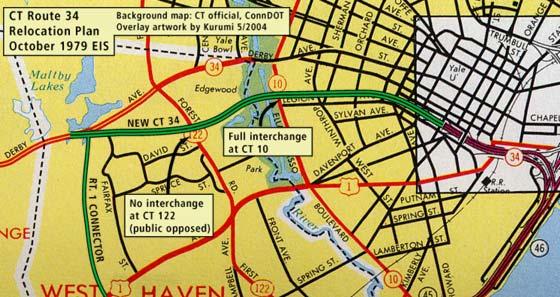
From the October 1979 EIS: the plan to extend the Route 34 freeway westward, connecting to existing Route 34 near Maltby Lakes. Includes connector to US 1.
Extension to Maltby Lakes and Route 1 Connector
The second phase of the 1953 plan was an extension of the Oak Street Connector to the vicinity of the West Haven / Orange town line, near the Maltby Lakes. This is slightly west of Route 122 and the start of the four-lane section of Derby Avenue.
In May 1957, design and ground surveys were started. Planners studying area traffic developed the concept of a "Route 1 Connector" in association with the new Route 34. The connector, a two-lane limited access road, would lead south from the Derby Avenue/New Route 34 area to US 1 as shown in the above map. The Route 1 Connector would relieve traffic on Forest Road (Route 122) and other nearby streets.
The following elements were also discussed at that time:
- Full interchange at Route 122 (Forest Rd.): later deleted due to public opposition
- Full interchange at Route 10 (Boulevard): under contention because of impacts to West River Memorial Park
- Separate structures for Dwight and Howe Streets: later combined by City recommendation for better traffic circulation
- Parallel collector-distributor roads along frontage roads: deleted some time after 1968; meager improvement to traffic overshadowed by loss of land and community impact
In 1965, the Connecticut General Assembly issued a Public Act calling for the design of a relocated Route 34 from the York Street terminus to Marginal Drive in West Haven, a point just beyond the Boulevard and the West River. By 1967 planners had arrived at a basic design in that area close to that shown in the figure above. Between 1966 and 1970, the state acquired land in the proposed Route 34 right of way, creating an empty swath still visible today.
Route 34 would have had a broad profile in this area: 12 lanes and a right of way up to 480 feet.
Design of this segment had started in 1966, but the project ran into problems, especially at parkland surrounding the West River. The state design called for a "land fill" across most of the Route 34 roadway, severing a manmade lagoon used by the Yale crew program. Mayor Richard C. Lee called for a longer bridge to cross both the lagoon and the West River, resulting in eight fewer acres of parkland lost.
In 1970, the westerly project limit was moved to the Boulevard, postponing the issue of crossing the river and park. That year, construction was expected to start in 1972.
Interruptions in design work continued as new priorities, laws, and administrators came into play. Between 1966 and 1976, when work was halted and a "90% complete" design was published, work stoppages had totaled five years.
In 1971, the expected construction start had slipped to 1976. Work west of the Boulevard wouldn't start until 1979. A city coalition came forward with an alternative design for Route 34: instead of a 12-lane freeway leading to the Boulevard, instead use frontage roads, and give back the land taken in the late 1960s.
In 1975, the state listing for the complete project was 2.6 miles, leading to the Orange town line, including the Route 1 Connector, for $51 million.
As the 1970s and 1980s passed on, no construction was done, and Route 34 remained as it had since 1960.
A more modest plan... thwarted
In the late 1990s, the state was ushering a smaller-scale plan. The Route 34 freeway would be extended three blocks west, to pass under Howe Street. Then it would transition into a four-lane bidirectional road with raised median, following the north frontage road. In the 1999 Master Transportation Plan, the state said it intended to advertise the $32 million project sometime in 2000. In late 2001, the project had been delayed, but was still on track for a groundbreaking in spring 2002.
However, it wasn't started. Instead, the pharmaceutical company Pfizer Inc. constructed a $35 million drug testing center one block west of the York Street Air Rights garage, directly in the path of the Route 34 extension. This was announced Feb. 4, 2003, and the building opened in 2004.
New Haven City traffic czar Brian McGrath cited budgetary reasons (tax benefits from the building, and unlikelihood of the state funding Route 34 anytime soon), and said to the New Haven Advocate: "The [road] plan is finished forever. The rest of the road will remain the way it is. The traffic will remain the way it is."
Downtown Crossing and Freeway Removal
In mid-2013, the city of New Haven began a project to dismantle part of the Route 34 freeway, by closing the Exit 3 offramp that served as the end of the freeway. Further changes will remove the Exit 3 onramp and the Exit 2 offramp. The Oak Street Connector will function more as a long connection to the I-91/I-95 interchange from frontage roads at Church Street.
On May 2, 2013, Exit 3 was closed; all westbound traffic instead used Exit 2. On July 14, 2014, Exit 2 was closed. The former Exit 1 is no longer signed with an exit number.
For more information, see downtowncrossingnewhaven.com.
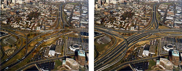
Before and after aerial photos (the second one simulated at the time) show the revamped Mixmaster interchange. All ramps are to and from the right, with greater width and higher turning radii. Ramps to and from Brewery Street are eliminated. Photos by ConnDOT; see
I-95 New Haven site.
A complete reconstruction of the interchange with I-95 and I-91 was completed around 2016, including signage for the Route 34 leg of the interchange. Since then, "Route 34" markers have been removed, and signs now say "MLK Boulevard".
A new East-West freeway to New York State
In the 1960s and '70s, Connecticut and New York contemplated building a new expressway to serve inland areas in Fairfield and New Haven counties. The highway would have entered the state at Ridgefield, continued east across Monroe to Shelton, then followed the Route 34 corridor into New Haven. The highway was never built, and the proposed number varied with time and proposing agency: Route 34; Route 35 (from the corridor in New York and Ridgefield, Conn.); and Route 110 (the Tri-State Transportation Commission). In 1975, the Regional Plan Association recommended that this plan be dropped, and it soon was.
Late '90s mall proposal included new ramps
A circa 1997 plan for a New Haven mall near the Union Station area would have added five more entrance and exit ramps to the short Route 34 freeway to handle the traffic. I have no idea where they would have been squeezed in.
About Mayor Lee
Richard C. Lee served eight two-year terms as mayor of New Haven: the longest tenure in the city's history. He was also the city's youngest mayor when he took office in 1954.
A World War II veteran, Lee grew up in New Haven, and though he never went to college, he recieved an honorary master's degree from Yale University in 1961. He passed away at the age of 86 in February 2003.
During his term, New Haven gained national prominence as a "model city": an example and experiment for philosophies and methods of 1950s and 1960s urban renewal. Several legal, equal opportunity and social programs, including Head Start, trace their origins back to New Haven.
Several buildings, public facilities and roadways, including Route 34, were developed under Lee's watch. He is also credited with making more acceptable the practice of consulting experts outside one's city.
Though Lee could have advanced up the political career ladder ("Dick Lee could have run for governor. He could have run for senator," said former Mayor John C. Daniels), Lee stayed with the city he grew up in.
Lee's legacy is mixed, and the outcome of his work depends on who you talk to. Not all the city experiments worked well. Some projects were said to have made the city worse off as designed. In addition, New Haven was fighting a tough battle against flight to the suburbs, racial unrest, and more. (All these conditions persist today.)
But supporters credit Lee with being open-minded, honest, and visionary, and bringing passion and professionalism to his office. And without his urban renewal projects, they say, New Haven would not be as well off.


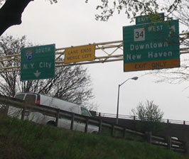 Guide signs at end of I-91 point out I-95 and the former east end of Route 34, the Richard C. Lee Connector. Photo taken from the sidewalk in New Haven's "Little Italy" section, May 2004, by Kurumi. (This photo is out of date; the Connector is no longer part of Route 34.)