Before US 1
The Boston Post Road, a 17th-century mail route, was one of the first named roads in New England. At New Haven, the Upper and Middle branches of the road turned north, and the Lower road followed today's US 1 toward Providence and Boston.
In 1922, a New England-wide route numbering system (New England Interstates) was established to help motorists find their way. North-south roads were given even numbers, and east-west routes were odd. The shore route was the exception, called NE 1 for its entire length.
In 1926, the US route numbering system was inaugurated, and NE 1 became part of a much longer US 1 from Maine to Florida.
Alignment changes - by location
Most of US 1 in the state follows the original 1926 route, but there have been a few changes over the years. We'll go from west (er, south) to east (north).
In the mid to late 1920s, several sections of US 1 between Greenwich and New Haven were widened to four lanes. In 1928, state officials believed US 1 was the longest continuous stretch of four-lane highway in the world.
In Westport, the "Southport Cutoff" opened in October 1930, carrying US 1 over the railroad, and eliminating such hazards as "Dead Man's Curve" and "Carey's Corner."
In Bridgeport and Stratford, the original US 1 followed Fairfield Avenue, State Street and Stratford Avenue (today's Route 130); the modern US 1 was called US 1A. US 1 was moved to its current location here in 1963.
In Milford, US 1 followed Bridgeport Avenue, Clark St, West Main St, and Cherry Avenue through town. The Boston Post Road segment of present-day US 1 was called US 1A. In the 1940s, US 1 was moved there and US 1A was deleted.
In East Haven, US 1 followed Main Street, which runs south of present-day US 1. Around 1941, the four-lane Saltonstall Parkway, bypassing Main Street. US 1 was moved to the new road, and Main Street became US 1A for a few years.
In Old Saybrook, US 1 northbound followed Old Boston Post Road due east from the western Route 154 intersection, then turned north on Main Street (today's Route 154) before picking up the Post Road again. Today's US 1 proceeds northeast from the western Route 154 intersection and has no overlap with Main Street. I've seen maps marking both new and old alignments as US 1A, a designation that was deleted in 1963.
Between Old Lyme (Route 156) and Flanders Village (Route 161), the original US 1 was located where it is now; but for several years in between it was located where I-95 is now. On Dec. 1, 1949 a new two-lane highway opened where I-95 is now; this became US 1, and the Boston Post Road here had no number. In 1963, this became Route 51, and US 1 stayed overlapped with the recently opened I-95. In 1977, US 1 was relocated back to Boston Post Road and Route 51 was deleted.
In New London, US 1 followed Bank Street, State Street and Main Street to Crystal Avenue, leading to a Thames River bridge which no longer exists now. In 1943, a new Gold Star Bridge opened, along with a short US 1 freeway between Route 32 and Route 12. A new two-lane highway connected the freeway to existing US 1 where I-95 and present-day US 1 meet near I-395.
In Groton, the original US 1 entered town on Bridge Street, then turned south on Thames Street. It followed Poquonnock Road, Tower Avenue and Runway Lane to return to present-day US 1 north of the airport. In 1936, a new segment opened to the north along present-day US 1 (Long Hill Road and Poquonnock Road). The 1938 official state map lists this as US 1A.
In Stonington, US 1 followed today's US 1A, coming closer to downtown. In 1939, the present-day US 1 bypass opened, and the remainder became US 1A. Out of up to 10 separate US 1A routes, only this one remains.
Rhode Island: "No Sale" on 1940s inland shift idea
In 1947, Connecticut proposed rerouting US 1 between New London and Providence to state route 84 (now Route 184) and Rhode Island state route 3—a more direct route between the cities. Rhode Island declined: it didn't want to remove US 1 from its shore towns, and lose money for four-laning the road there.
Rhode Island countered with a US 1A proposal for the 84/3 route. Connecticut agreed, and it was sent to AASHO. Afterward, it was either rejected or retracted, because US 1A was never posted along the route.
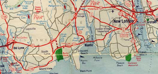
In 1957, one year before it would be incorporated into the Connecticut Turnpike, US 1 was a two-lane access controlled highway ("Super 2") between freeway sections in Old Lyme and Waterford. Interchanges were present at several future I-95 exits including 71, 73, and 74. Scan taken from the 1957 official state highway map.
US 1 upgrades
Though eclipsed now by I-95, for many decades US 1 was the state's busiest and most important road. In the 1920s, US 1 in Fairfield County was already being widened to four lanes, and the traffic had earned it the nickname "The Roaring Road." A few highways owe their reason for existence to the need to relieve traffic on US 1:
Before I-95 came along in 1958, however, several improvements belonged to US 1 itself. Unless noted, these were completely absorbed into I-95.
Saltonstall Parkway, New Haven - East Haven
Around 1941, a four-lane divided highway, the Saltonstall Parkway, opened in New Haven and East Haven. Access was partially controlled; probably the only reason Route 100 crossed on an overpass was to also cross over the adjacent rail line. The western part of this highway was incorporated into the Connecticut Turnpike (I-95) in 1958, with a treatment including some frontage roads.
Gold Star Bridge and freeway approaches, New London - Groton
In 1943, the new Gold Star Bridge opened across the Thames River between New London and Groton. (The second span was added in 1975.) A new US 1 freeway was built there, leading from around Colman Street to Route 12. Wartime restrictions had prevented the desired freeway extension westward to Route 85; instead, a new two-lane connected the freeway to present-day US 1 near Route 161. This is all part of I-95 now, except for the short Route 184 freeway stub, which back in the day led to the old state route 84.
Baldwin Bridge and freeway approaches, Old Saybrook - Old Lyme
In 1948, the original Baldwin Bridge opened at Old Saybrook to cross the Connecticut River. US 1 was upgraded to a four-lane freeway here, with an interchange on each side: Route 80 in Old Saybrook (now Route 9), and Route 156 in Old Lyme.
Blue Star Highway, Old Lyme - East Lyme
On Dec. 1, 1949, between Old Lyme and Flanders Village, a new eight-mile, $2.5 million "Super 2" (two-lane undivided freeway) opened, south of the Boston Post Road. (Unfortunately, the state highway inspector had to immediately order it closed, because it had been built without guard rails.) It eventually opened for good. The 1957 state map shows interchanges at future I-95 exits 71 and 73, along with a proposed connector to Rocky Neck state Park.
Darien Bypass, Darien
On Sept. 14, 1953, a short segment of freeway was opened to bypass the "choke point" on US 1 where Route 136, Route 124, the old Route 118 and a railroad overpass converged.
Another mile in New Haven
In October 1953, a $1 million, 1-mile link of four-lane freeway opened, connecting the Tomlinson Bridge over the Quinnipiac River to the Saltonstall Parkway.
A US 1 freeway proposal - post I-95
The opening of the Connecticut Turnpike in 1958 and the remainder of I-95 in 1964 shut down any large-scale improvement prospects for US 1: its role had irreversibly changed. In West Haven, however, an early 1960s proposal described a way US 1 could shine on its own (for a few miles).
In 1962, a comprehensive 20-year plan was commissioned for the city of West Haven. Three short freeways were proposed in town, including a relocation of US 1. At this time I-95 was already open, and would not absorb this section of US 1.
The relocation was intended to relieve local traffic on US 1, especially at its junction with Route 122. The new freeway would leave US 1 southeasterly near Fairfax Street, run approximately along Terrace Avenue (i.e. displacing it), and end at a north-south freeway (probably Route 100 between Front Street and the West River.
The plan didn't go far; other than a 1962 New Haven Register article, I've never seen it mentioned anywhere.


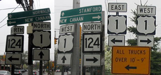 Should US 1 be signed north-south (as the highway runs nationwide), or east-west (as it does in Connecticut)? At Route 124 in Darien, you see both. Photo taken by Kurumi in April 2004.