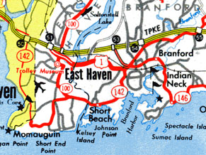
From 1963 to 1969, Route 100 extended south to end at an extended Route 142. Scan from 1965 official state highway map.
In the 1920s, the state's internal highway numbers began with 101, so there was no state highway 100.
First Route 100, Danbury - New Fairfield
In 1932, the first Route 100 was created along what is now Route 39 between New Fairfield center (at Route 37) and Danbury center.
In 1934, the route was decomissioned and divided up between an extended Route 39 (Ball Pond Road and Milltown Road into New York State) and a new Route 37A (the remainder of Ball Pond Road and Clapboard Ridge Road to Danbury).
Second Route 100, East Haven, and its dance with Route 142
In 1935, the modern Route 100 was commissioned in East Haven on High Street, from Main Street (US 1 at the time) to Route 80, a length of 3.92 miles. This is all part of the route's alignment today.
In 1940, US 1 was relocated from Main Street to the new four-lane "cutoff" route (now Saltonstall Parkway). Route 100 now passed over US 1 on a bridge with no direct access. Main Street became US 1A, a designation that lasted until 1962, though it did not appear on most state maps.
In 1943 Route 100 was extended south along Thompson Avenue (replacing old SR 558) to Dodge Avenue, for a total length of 4.69 miles.
Sometime in the 1950s, Route 100 was redefined to turn east at Main Street to end at Route 142, at the corner of Main Street and Hemingway Avenue.
In 1963, Route 142 was extended westward along Silver Sands Road (and most of today's Route 337) into New Haven. Route 100 was extended southward along Hemingway Avenue and Short Beach Road to end at Route 142.
In 1969, however, the state reversed its change to Route 142, leading to the 1950s configuration for that road and Route 100.
The portion of Main Street east of Hemingway Avenue, once part of US 1, then US 1A, became unsigned SR 744 in 1962. The state cancelled that route in 1974, but adopted it some time later as SR 906. In 1993, Route 100 was extended over SR 906 to meet US 1 where it does today.
In 1999, Route 100's intersection with Route 80 was relocated slightly, and Route 100's length decreased by 0.04 mile.
The post-1993 terminal intersection with US 1 was once more channelized, including a free-flow right turn onto US 1 south. To reduce the number of accidents there, the state converted it to a traditional T-intersection around 2012.

