New England Interstate route 12
Route 12 descends from NE-12, an early "New England Interstate" created in 1922. Originally NE-12 followed the west bank of the Thames between Norwich and New London, while NE-32 followed the east bank: the opposite of where Route 12 and Route 32 are located today. In 1932, these route segments were switched.
Between Gales Ferry and the Gold Star Bridge approach, Route 12's original post-1932 alignment was Military Highway, a road quite close to the eastern bank of the Thames. Since that road passes through a naval base, Route 12 was shifted eastward to its current location on Dec. 2, 1943. Military Highway stayed in the state system as an unsigned route (SR 428, then SR 628) before being removed in 1963.
Freeway plans
Route 12 was the main drag between New London, Norwich and Worcester, Mass., until the cities were linked by expressways in the 1950s, 60s, and 70s. Now three different interstates (I-395, I-290, and I-190) serve the Route 12 corridor.
In 1958, the Connecticut Turnpike opened, serving Route 12 towns from New London to the "elbow" in Killingly, where the turnpike turns east toward Rhode Island. At the time, the state was already planning "relocated Route 12" to continue north toward Massachusetts.
Relocated Route 12 opened in stages throughout the 1960s and early '70s -- but the freeway was never signed as Route 12. In 1965, the state assigned Route 52 to the completed and future freeway from East Lyme to the Massachusetts state line. In 1982, officials in Connecticut and Massachusetts discussed designating Route 52 as I-290; however, the following year, I-395 was the number assigned to it.
Innovations in Killingly
West of the relocated Route 12 (aka 52 aka I-395), the real Route 12 once intersected US 6 in a half-interchange and rotary, both of which opened in 1958. The 2-lane Danielson Connector, since incorporated into I-395, connected the area to the Turnpike. In 1996, however, the rotary and grade separation were dismantled in favor of conventional signalized intersections. For more information, see Killingly (Danielson) Roads.
Route 12/117 freeway proposal
From 1967 into the early 1970s, the state and the Southeastern Connecticut Regional Planning Agency (SCRPA) studied the Route 12 and Route 117 corridor south of Norwich for a possible freeway. One of the main difficulties was finding a place to connect this highway to I-95 without getting tangled in other nearby interchanges. No freeway was built.
Beautification and revitalization
Reportedly there was a plan to widen Route 12 and Route 97 to form a continuous four-lane connection between I-395 near Taftville and I-95 in Groton; however, I've never found more information about it.
Here's to our Submariners
In May 2002, the state legislature's transportation bill included a provision to name Route 12 the "United States Submarine Veterans Memorial Highway" between US 1 and Route 2A. "We were kidding everyone that they liked Route 12 because of the bars," said bill supporter State Rep. Nancy DeMarinis, but the location is appropriate because of the Naval Submarine Base and housing near the highway.
This was approved in mid-2002, and now Route 12 is the first road in the nation to honor submarine veterans.


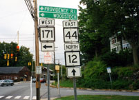 Route 12 and mis-signed US 44 at Route 171, in Putnam. Photo taken Sept. 2002 by Kurumi.