On Jan. 1, 1932, the state renumbered nearly every highway in Connecticut, to mark routes more useful for motoring inside Connecticut and into neighboring states. Planners worked with almost a clean slate, and the eastern half of the state featured a sequence of odd-numbered north-south routes in order, from Route 77 in Guilford and Durham, to Route 95 (now Route 49) from North Stonington to Sterling.
Route 97, also debuting in 1932 but nestled between State Route 91 (now Route 198 and Route 171) and State Route 93 (now Route 169) was a bit out of place. The reason for this: Route 97 was one of the last highways to be added, in the final months of 1931.
In mid-November 1931, the state had penciled in these numbers for what would later become Route 97:
- Norwich to Baltic: Route 209
- Baltic to Scotland town line, along Baltic-Hanover Road and Hanover Road: also Route 209
- Scotland and Hampton: not a state road
- the "stair step" segment in Pomfret, between US 44 and US 44: Route 201
Route 209 was never signed in the area (to my knowledge) and appears on no state maps, until the number was used near Bantam Lake in 1963. However, the eastern Route 209 has appeared on a few maps from other publishers, such as the below AAA map showing Route 209 (and Route 97) in 1935.
Route 209, a proposed but unused designation for part of Route 97, survives in this 1935 AAA map of southern New England.
On Jan. 1, 1932, Route 97 was commissioned, following this alignment, starting in the south:
- Today's Route 97, from Route 12 in Norwich to Baltic
- Baltic-Hanover Road and Hanover Road, to Route 14 in Scotland (this is east of today's Route 97)
- Today's Route 97, from Route 14 in Scotland into Hampton
- Station Road and Morey Road from Hampton Center to Route 91 (today's Route 198) in Chaplin.
The "stairstep" section of Route 97 north of US 44 in Pomfret was called Route 201. The remainder of today's Route 97 in Pomfret and Hampton was not originally numbered.
Between 1932 and 1934, Pomfret Road in Hampton and Hampton Road in Pomfret were added to the state highway system as SR 860.
In 1934, Route 97 was rerouted straight north from Hampton, absorbing SR 860 (noted above) and the old "stairstep" Route 201, to end at old Route 93 and 101 (now Route 169 and US 44). Station Road and Morey Road, heading into Chaplin, were turned over to town maintenance.
In 1947, Scotland Road in Sprague and Devotion Road in Scotland were added to the state highway system as SR 870.
In 1949, Route 97 was shifted west to SR 870, and the former alignment (Baltic-Hanover Road and Hanover Road) became SR 871. Portions of SR 871 remained as a state highway until 1962; now those roads are locally maintained.
Also in 1949, a portion of Route 97 was realigned in Hampton; this might have been near Old Kings Highway.
In the 1960s and '70s, an eastern alignment of Interstate 84 was planned through Hampton en route to Providence. If this had been built, Route 97 would have been widened near the proposed interchange at the Hampton - Scotland town line.
Proposed Baltic Spur
In 1969, area lawmakers advocated a new divided highway involving Route 82 and Route 97:
...authorization for bonds to finance a divided highway from Exit 80 of the Turnpike [now Exit 11, I-395] through Norwich to Exit 83 [now Exit 18, for Route 97], continuing on Rt. 97 to the center of Baltic; [and] a highway from Rt 2/32 connector in Norwich Town to the proposed highway from Exit 80 to Exit 83.
This proposed highway (freeway, or boulevard) following the Shetucket River's west bank never got off the ground.
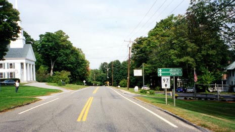
Facing north on Route 97 in downtown Hampton, Conn. Just a few buildings make up the center of this quiet town. Light traffic allows the "stand in the middle of the road" view here. Photo taken Sept. 2002 by Kurumi.
Scenic Road in Pomfret
In January 2001, a segment from the Hampton town line to Route 169 in Pomfret was submitted to the state's Scenic Road Advisory Committee. In April 2001, the commission determined that the portion south of US 44 did not provide a "continuous representation of the character or the criteria of a scenic roadway"; in other words, that part of Route 97 wasn't very scenic.
However, the 4.5-mile portion from US 44 to US 44/Route 169 (the aforementioned "stairstep" section) was approved as a scenic road on April 27, 2001. This designation helps protect the road from state modifications that might mar the scenery.
Other plans
Circa 2002, there was a plan to widen Routes 12 and 97 to form a continuous four-lane connection between I-395 near Taftville and I-95 in Groton.
Although Route 97 does not need the large-scale widening planned in conjunction with I-84 to Providence, the road is quite narrow (18 to 20 feet) in northern Scotland and was planned to be reconstructed in 2002 to make it safer.

