
Updated June 12, 2025
The "Ring Road" was a proposed urban roadway circa 1960s to encircle downtown New Haven, leading from the Trumbull Street interchange at I-91 around to Route 34 or further south. I've never seen a route number assigned to this proposal.
There's little information on this road compared to other projects, such as Route 34 or the East Rock Connector. The Ring Road would have had a mixed profile, part expressway and part arterial road.
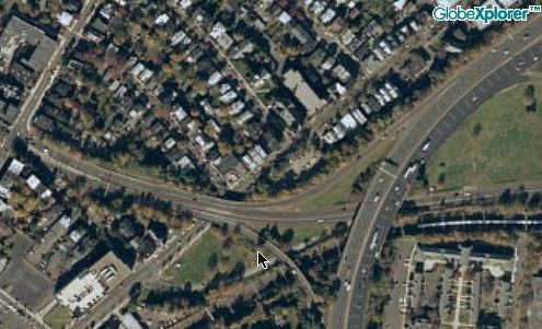 From a trumpet interchange at I-91 exit 3, this short connector road overpasses State Street and ends at a signalized intersection with Orange Street. Trumbull Street continues to the west. The Ring Road would have continued in that direction as well. Aerial photos like this sample used to be available at Mapquest.com.
As highway information citations go, my first source for the Ring Road stands out: it's a Black Panthers pamphlet from 1970, criticizing Yale, New Haven officials, and business interests.
The text discusses the Oak Street Connector (Route 34) and its role in displacing Oak Street ("the city's worst slum") and separating black neighborhoods from the college and downtown. Then:
The second project to complete the encirclement of Yale is the ring road. The projected inner loop road will effectively isolate Yale from Dixwell and the rapidly expanding black population in the Dwight neighborhood across Howe Street. It will also save the Medical School from the blacks and Puerto Ricans in the Hill.
This loop, part expressway and part boulevard, will start from the I-91 Trumbull Street exit, an engineering disaster, circle behind the Grove Street Cemetery and Payne-Whitney gym and go down Howe and Dwight to the turnpike connector, which is being extended, and then circle beyond the medical school-hospital complex and join State Street, by then a six-lane road. Early plans for this road forsaw displacing 36 families, moving 31 businesses, and spending $1.6 million for land acquisition (of which half a million would pay for Yale property).
In the Panthers' view, the road joined with Route 34 and I-91 would form a complete fence around Yale and the retail downtown.
In 1942, Yale professor Maurice Rotival wrote an urban traffic plan for New Haven that included several roads, including Route 34, a highway through East Rock, and "several ring roads" to speed motorists on their way. He updated his plan in 1953. One of these Ring Roads might have been the one we're discussing now. His papers are archived at Yale; I haven't seen them yet – other than the reference scan below.
 Yale University posted this scan from its Rotival papers collection (dated 1944-1963). Shown is: something close to the Ring Road; a Willow Street connector; US 1 and US 5 freeways; Route 34, and a Route 10 highway (upper left).
In December 1965, Yale President Kingman Brewster and New Haven mayor Richard C. Lee presented the idea of an "inner circumferential" route, connecting I-91 and Route 34, to the state. (There was not a definite "outer circumferential" plan at the time.)
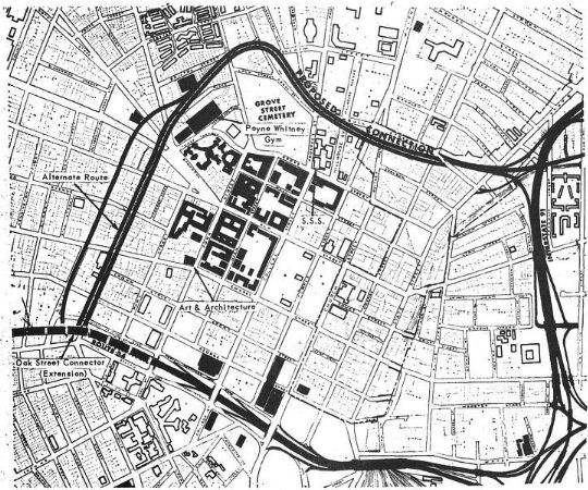 This 1965 plan depicts a definite east-west segment leading from the Trumbull Street I-91 interchange, and two alternatives for the north-south segment connecting to Route 34.
The road would be two or three lanes in each direction, partly underground, with many details not yet fleshed out. Both a widened Howe Street and a one-way pair of Dwight and Howe Streets were considered. I haven't seen details of any interchanges other than Trumbull Street at I-91.
There was even a southern portion proposed, following Howard and Columbus Avenues back to State Street.
What was the road's purpose? Any of the following:
In mid-1966, to satisfy some Yale interests that opposed the road, Mayor Lee agreed to place the Trumbull Street portion in a tunnel. In 1967, plans also included a tunnel under the Broadway traffic circle.
By late 1968, the Ring Road seemed to be on the wane. In September 1968, state highway department directory David S. Johnson explained that the "ring road", supported by the city, had not been taken into consideration when designing the Route 34 extension. But the city's official position at the time was that there were "no drawn plans" for the ring road.
A December 1968 New Haven Register editorial stated: "We agree that the so-called Ring Road, designed to connect the Oak Street Connector with the Trumbull Street ramp of I-91, should be abandoned."
In both New Haven Register articles, the Ring Road was enclosed in quotation marks, or prefaced with "so-called", or both – doing no favors to the proposal's credibility.