Statewide planning
The general alignment of Interstate 91, within a few miles, has been set since the mid-1940s. At that time, a network of interregional highways was laid out for the United States: a system that later became our familiar interstate highways. In 1947, Connecticut's portion was a $262 million, 370-mile network including US 1 and Route 84 (today's I-95); US 6 and Route 15 (today's I-84); and US 5 and 5A through New Haven, Meriden, Hartford, Windsor Locks and Enfield (today's I-91).
On August 14, 1957, the American Association of State Highway Officials (AASHO) approved the general routes for interstates 84, 91, and 95. On June 27, 1958, it approved the numbers.
Conland Highway - Hartford
The earliest freeway to be incorporated into I-91 is the Conland Highway (1945), which led from a trumpet interchange at the western approach to the Charter Oak Bridge ("COB"), north to today's I-91 exit 29A, then along the Conland - Whitehead Highway to Pulaski Circle. The highway would have opened earlier if not for wartime restrictions in the early 1940s (construction was halted in Sept. 1942). The highway was opened from the COB to Commerce Street (now Columbus Blvd.) on Oct. 3, 1945; and from Commerce Street to Pulaski Circle a month later.
In planning documents, the portion later to be I-91 was often called the Dike Highway, as it would run on top of a new flood-control dike along the Connecticut River.
North Meadows Highway and beyond - Hartford to Enfield
In 1943, an express highway was planned for North Hartford, extending to Route 75 in Windsor, including a western spur to Tower Avenue. Even though the Tower Avenue spur became part of a larger plan in 1949 to link to Route 189, it was eventually deleted.
Construction of the North Meadows Highway started in 1948, and "old-timers" in the area will remember the service roads at exit 33, a design feature that was replaced in the 1990s with a conventional diamond interchange at Jennings Road. The segment from a traffic signal at Morgan Street to Main Street at Wilson opened in November 1950.
In 1952, detailed plans for I-91 north of Hartford were shown, and were almost identical to I-91 today, including a connector to Bradley Airport. The highway, now called the Veteran's Highway, was extended to Windsor Locks in 1958 and Enfield in 1959. The first signs identifying the road as I-91 were installed in March 1961.
The Wilbur Cross connection
In 1949, the Wilbur Cross Parkway (Route 15) was complete from the Merritt Parkway in Milford to the the Meriden Cutoff north of Meriden. The question: what to do north of there? The Berlin Turnpike had been improved in 1942 to handle Hartford-bound traffic, but the issue of a cross-state express highway remained.
As traffic levels increased, Route 9 (today's Route 99 and 154) got attention as well, and one 1950 proposal involved extending the Wilbur Cross Parkway northeasterly to Cromwell (near Route 3/9/372 today) then north to Hartford. 15 years later, I-91 opened along a straighter alignment, and a separate expressway was planned for Route 9.
Heavy traffic on the Silas Deane Highway portion of Route 9 in Rocky Hill and Wethersfield (today's Route 99) had earned it the uncomplimentary moniker "Death Alley." In 1952, a bypass link was planned, following the eastern route around Wethersfield that I-91 takes today.
Hamden and Wallingford
Once it leaves New Haven, I-91 swings outside town and city centers until it reaches Hartford; a dramatic turn eastward avoids Hamden and Wallingford, while US 5 continues through the center of town.
Originally, I-91 was to follow US 5 more closely south of Meriden, more directly serving those towns. Some proposed alignments even passed west of Wallingford Center, running next to Route 15 for a few miles.
However, Hamden (and possibly Wallingford) opposed building the expressway through downtown, leading to where I-91 goes today. In the early 1960s, the state and Hamden were already discussing a spur for access to I-91 -- a project that eventually became Route 40.
In all, at least three highway proposals -- the East Rock Expressway, Route 40, and the Wharton Brook Connector (SR 702) -- were intended to give I-91 access to the US 5 and Route 10 corridors to the west.
I-91 opening dates
- From I-95, New Haven to relocated US 6A (now I-691), Meriden: 18.8 miles, $54.5M, Jan. 7, 1966. (Connecticut's first Jersey barriers were installed here in 1968.)
- From relocated US 6A (now I-691), Meriden, to Rocky Hill: 11 miles, Oct. 27, 1965.
- From Charter Oak Bridge to Conland-Whitehead Highway: Oct. 3, 1945.
- Morgan Street (now I-84) to Main Street (now CT 159), Hartford: Nov. 1950.
- From Main Street to Windsor Locks: 1958
- From Windsor Locks to Enfield: 1959
Planning a wider I-91 north of Hartford
Even before the last section of I-91 opened in southern Connecticut in 1966, the 1940s and 1950s-era highway north of Hartford was already considered obsolete, and widening it was unfinished business. In 1964, the plan was to make I-91 eight lanes wide from US 5A (now Route 159) in Windsor to Route 75. In 1966, the state added a plan to make I-91 six lanes wide from Route 75 to Route 20.
One reason for the Route 75 stopping point for the eight-lane widening: this section of I-91 was built in 1956, before federal funding was available, and thus was eligible for 90% federal funding to add two lanes in each direction. North of Route 75, I-91 had been constructed with federal funds and thus was only eligible for 50/50 funding.
By 1971, the state was considering bus lanes as part of the widening, either as adjacent "diamond lanes", or permanent special lanes, in a planned 8-lane profile north to Route 20.
At the same time, however, hearings were held for a non-HOV I-91 widening, from Morgan Street to Bina Avenue, 8 lanes wide. Bids were to go out in 1972.
Widening northern I-91
In the late 1980s, I-91 was rehabilitated north of Hartford. North of Route 20, I-91 was widened in-place to six lanes (from four), but its profile was otherwise the same. The original highway had opened in 1959.
South of Route 20, I-91 was completely reconstructed in a manner similar to I-84 in eastern Connecticut: new bridges, new interchanges, and an eight-lane profile including two separate HOV lanes.
I-91/I-84 interchange
On October 14, 1998, an eleven-year period of construction ended on I-91 near the Founders Bridge and I-84 in Hartford. I-91 southbound was moved from above to below the Founders Bridge approaches, to allow for a pedestrian walkway to the river. Also, direct flyover ramps were added to complete the interchange at I-84, taking thru traffic off city streets. There's detailed information at the I-84 page.
Nobody beats our prices
Work was halted for two months in 1997 when the financially troubled contractor, George A. Tomasso Construction Corp., was replaced by O & G Industries. Eight of the nine original bids for the project ranged from $104 million to $127 million; Tomasso's bid was $68 million.
Tomasso had halted work on 19 state projects not two years earlier, in September 1995. Other evidence showed that not only was the company overextended, but the head of the company was psychologically troubled. In May 1992, he entered the office of Balf/Savin, a competitor, and told employees he had purchased the company and they were dismissed. Neither was true. Employees called police, and an ambulance took Tomasso away.
The preceding paragraphs don't tell the complete story, and I don't intend to trivialize the lessons shown in the sources about how relations between politics, contractors, and projects can go awry.
Shoreham-New Haven Bridge
In the 1960s and 70s, plans were floated for a 19-mile cross-Sound bridge linking New Haven and Suffolk County, Long Island. I-91 would have been extended across the bridge along an upgraded William Floyd Parkway to I-495.
Two approaches on the Connecticut side were considered. The first would touch land in East Haven and connect to I-95 just east of the Quinnipiac River Bridge (exit 50-51). The second would enter at West Haven, reaching I-95 between exits 43 and 44. The East Haven approach was preferred as the less disruptive one.
Estimates for the cost of the bridge, which would have been one of the longest in the world, exceeded $1 billion in 1979. That year saw contention over the project come to a head as most Suffolk county politicians supported the bridge, while Connecticut Gov. Ella Grasso saw little benefit for her state. The bridge has not been discussed much since then; attention has gone to developing a high-speed ferry link in the area. For more information, see Steve Anderson's excellent Shoreham-New Haven Bridge page.
Spot Improvements
In the early 1990s, the I-91/Route 15 interchange at the Charter Oak Bridge was modified. The original interchange was a modified trumpet, alluding to the 1940s when Route 15 was the primary highway and today's I-91 north was the Conland Highway, a spur toward the Capitol Area. From I-91's perspective, the interchange had left exits from both directions on I-91 toward the bridge.
The new interchange is incomplete, with the less frequent movements removed (15 south to 91 north and 91 south to 15 north).
In 1994, a revamped freeway interchange with Route 3 opened in Wethersfield. This was originally to be the I-491 interchange.
In 1999, an operational lane in each direction was added near exit 23 in Rocky Hill. This project included work on the old I-291 interchange in this area made some passersby think that freeway was being disinterred; however, I-291 is still dead, dead, dead. They were only clearing out the area for the extra lanes.


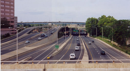 Complicated collector and distributor ramps at the I-91/I-84 interchange in Hartford. View is northward from the Founders Bridge pedestrian walkway over I-91. This interchange was reconstructed in the late 1980s and completed in 1990.