The original highway through Windsor, Poquonock and Suffield was created in the mid 1920s. State Highway 110 ran along parts of today's routes 159 and 75. Starting in Hartford, it followed Main Street north to Windsor Center; Poquonock Avenue into Windsor Locks and Suffield; and then Mapleton Avenue, northeast and then north across the state line.
When state roads were renumbered in 1932, SH 110 was split up among US 5A (today's Route 159), and Route 75, which included today's route from Windsor to Suffield, and the Mapleton Avenue route back to US 5A. Route 75 began and ended at US 5A, for a length of 13.35 miles. The portion later to become part of Route 75 – North Street in Suffield – was designated SR 901.
As Route 75 was an alternate to US 5A, the Florida-style designation "A5A" would have been strange but appopriate.
Extended into Massachusetts
In July 1950, Route 75 was relocated from Mapleton Avenue to North Street, and extended into Massachusetts. SR 901 was replaced; the Mapleton Avenue segment became SR 902. In 1951, SR 902 was turned over to the town.
New bridge at Poquonock eliminates a sharp turn
In Poquonock (part of Windsor), Route 75 crosses the Farmington River at an oblique angle to provide for a straight roadway. The earlier crossing, a girder bridge from 1869, crossed the river at a perpendicular angle slightly east, making the roadway curved on each side. The new bridge was completed in 1953, and the old one was demolished. Part of Tunxis Street is old Route 75 here, and remained in the state highway system as SR 448 until 1962.
Impacts from Bradley International Airport
Originally called Bradley Field, the Windsor Locks airport opened for military use in 1941. In June 1942, Route 75 was closed to thru traffic, from Halfway House Road to the Suffield town line, for the duration of World War II. In 1947, the airfield began serving civilian flights as Bradley International Airport.
Around 1961, the state proposed widening 2.24 miles Route 75 to four lanes, from the new Route 20 freeway to the Suffield town line. This area is a mix of industrial and airport-related businesses, and has substantial traffic. This widening was completed around 1982.
Scenic Road
In January 2001, a segment from Austin Street in Suffield to the Massachusetts border was submitted to the Connecticut Scenic Road Advisory Committee. In March 2001, the committee determined that Route 75 near Austin Street did not meet the criteria, but approved the segment north of Stony Bridge Brook.


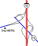 Upgraded interchange at I-91 includes a direct connector over Route 75 to Day Hill Road.