In the 1920s, "Route 4" was NE-4, a New England interstate route that became US 7. Both US 7 and NE-4 followed present-day
Route 41 out of Massachusetts, through the northwest corner of Connecticut into New York.
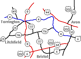
The Original Route 4
Today's Route 4 was commissioned in 1932, extending from the New York state line in Sharon to Route 10 in Farmington. There were small and large differences compared to today; here's the original route, from west to east.
- Today's Route 361, from the state line to Route 41
- short overlap with Route 41
- Cornwall Bridge Road (today's Route 4) to Dunbar Road in Sharon
- Dunbar Road and West Woods Road in Sharon; this is an old alignment that was bypassed in 1933 or 1934.
- Today's Route 4 to E. Main Street in Torrington
- Today's US 202 to Torrington Avenue in New Hartford
- Torrington Avenue (a local road) to Route 179 in Collinsville
- Today's Route 179 to today's Route 4
- Today's Route 4 to Route 10 in Farmington
Hartford area, 1940s
At the time, US 6 continued along Farmington Avenue into Hartford.
Around 1940, US 6 was moved south, and Route 4 was extended to end at US 5 in Hartford (according to the highway log). The exact location is not clear, but this might have been Asylum Street at Ford Street.
Between 1945 and 1947, the east end of Route 4 was redefined to be the Hudson Street Rotary, better known as Pulaski Circle, the western end of the Conland-Whitehead Highway, SR 598, which opened in 1945. Its length was now 58.27 miles. In 1949, its start and end were the same, but its length had changed to 57.70 miles.
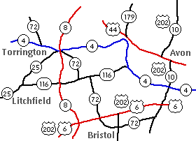
Torrington area, 1963
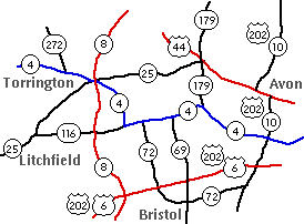
In 1963, between Torrington and Burlington, Route 4 was moved from its northern alignment along today's US 202 to where it currently is today. However, that summary understates the scope of changes in the area over a 20-year period from 1954 to 1974. Below, some of the earliest maps I drew for this site (in 1996) show what has changed.
Original Route 4 takes a northern route between Burlington and Torrington. Present-day Route 4 follows old Route 116 and Route 117. Route 4 also originally ended at Route 10 in Farmington.
In 1954, Route 72 was extended to the Massachusetts state line, replacing Route 117 and Route 49.
In 1963, Route 4 moved south, replacing part of Route 116. The remainder was divided among an extended Route 25 and Route 179. The extended Route 72 was rolled back, but the Route 49 number was already in use elsewhere and that portion became Route 272.
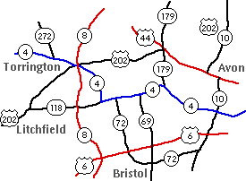
In 1974, US 202 was rerouted away from Route 10 and US 6, taking the path of Route 25 from Torrington to New Milford. Also, Route 116 was renumbered
Route 118.
Being a good neighbor, Sharon
In 1966, Connecticut renumbered three routes that had been discontinuous at the New York state line to match their counterparts. Connecticut Route 29 and New York Route 394 became a shared Route 124. A portion of Route 33 became an extension of New York Route 116. The third change was Route 4, which was rolled back to Route 41 so the remainder could match New York's Route 361. (In 1980, however, New York removed NY 361 from its highway system.)
Route 4 Relocation Plans, Farmington
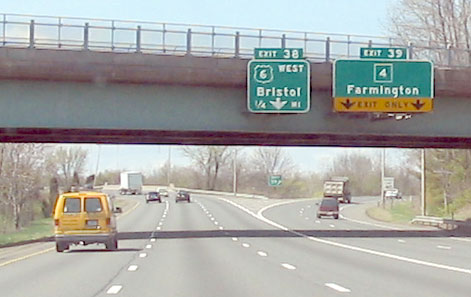
In the 1960s, a few plans were floated for relocating Route 4, both to bypass downtown Farmington and to connect I-84 to a planned Route 10 freeway. Neither was done, though SR 508, a freeway connector to Route 4 from I-84 Exit 39, was started in 1969 and extended in 1972.
In 1962 and 1963, the Tri-State Transportation Commission and the state of Connecticut proposed a four-lane freeway treatment, extending from I-84 exit 39 to proposed Route 10, slated for 1972. This was later cancelled.
In 1968, the Route 10 freeway plan was still active, but a Routes 4 and 10 planning study had changed the proposed role of Route 4 to a two-lane controlled-access highway, bypassing Farmington Village to the south. Starting at the I-84 connector, the highway would connect with the Route 10 freeway and terminate at existing Route 4 (Collinsville Road) near Unionville. From east to west, the highway would have included:
- New highway from the I-84 connector to Meadow Road. Part of this would be built on railroad right-of-way for sale at the time.
- Portions of Meadow Road, Red Oak Hill Road and New Britain Avenue, following the old tracks.
The plan's top construction priority for the area was the I-84 Connector to Meadow Road portion, which was recommended for construction as quickly as possible.
Route 4 was never relocated. Over the years, various plans for bypassing traffic have been discussed (see below).
Approaching Route 4 connector (SR 508) on I-84 westbound. It's signed as Route 4, but technically only connects to Route 4, about a mile away. Poor-quality photo, that I won't admit to taking, April 2004.
The Route 4 Connector
What did get built was the I-84 connector, leading from a jughandle intersection on Route 4 to Exit 39 on I-84. This is signed as "Route 4" on I-84, but is technically SR 508.
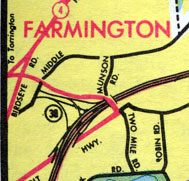
Scan of 1971 official highway map shows the partially-built Route 4 connector, ending at Patrick Flood Road.
A portion of the connector opened in 1969, along with I-84, but ended at Patrick Flood Road, beyond which federal funds could not be applied. Residents were unhappy about traffic being dumped onto the local road, and others opposed an extension that they feared would lead to widening Route 4 through Farmington. On Dec. 15, 1972, a $3.4 million extension of SR 508 to the jughandle at Route 4 opened to traffic.
Bypassing Farmington Center
The center of Farmington, where it intersects the two-lane Route 10, is the choke point for the two-lane Route 4, causing long lines of stopped traffic.
This was a problem recognized in the 1960s, as the construction of I-84 to the east was imminent. In 1967, the plans for Route 4 heading westward were in flux, but the connector was proposed as built today. The "Citizens for Farmington" group of residents, wary of the traffic that would flow on Route 4 through the village center, proposed the following alternatives to reroute traffic:
- build the Route 10 freeway between US 6 and Route 4, near the western town line
- improve the "Five Corners" intersection at US 6 and Fienemann Road (to encourage east-west traffic to use US 6 instead of Route 4)
- build I-291 from I-84 to Route 4 at Oakland Gardens
These projects would create an effective Route 4 bypass, the group contended. However, neither Route 10 nor I-291 were built, and the connector was.
Other plans have surfaced over the years. In 1998, a $118 million "Northern Bypass" proposal was rejected. The four-lane road would have skirted a West Hartford neighborhood and taken out more than a dozen houses in Farmington before ending at Route 167 in Avon.
In the wake of this, planners in c. 1999 were considering other options, including: four-laning US 6 between I-84 and Route 10; completing the interchange at exit 38 to provide complete access to US 6 from I-84 eastbound; and changing I-84 between routes 6 and 9 so that three continuous through lanes are provided.
In June 1998, the state conducted a public information meeting concerning proposed improvements to Route 4 near the end of the I-84 connector. According to the plan, Route 4 itself would be shifted north to move away from houses to the south. South Road (SR 531) would be moved northeast to form a T-intersection with Route 4, and Birdseye Road (SR 549) to the east to form a T with South Road. (Currently, both roads cross and form Y intersections with Route 4, east of the I-84 connector.) Route 4 would have two thru lanes in each direction at South Road. Double left-turn lanes would be provided at the two intersections. This proposal was eventually constructed.
On January 12, 1999, a package of improvements was approved by the Farmington town council. Highlights of the plan: Route 4 westbound would remain one lane. Route 4 eastbound would be two lanes from Garden Street to I-84. Turn lanes would be added at Route 10, and the South Road intersection will be upgraded. Estimated cost is $4.4 million. The same highlights were included in CRCOG's summary of recommendations from the Route 4 Corridor Study in early 2001.