Early Route Numbering
Numbered highways arrived in New England in 1922, including a New England Interstate system of routes across the six states. The U. S. highway system arrived in 1926, though some routes were not signed until later.
New England Interstate route 4, running from New York City to the western spine of Vermont, was the precursor to US 7. NE-4 cut across the northwest corner of Connecticut, following today's Route 41 through Sharon and Salisbury.
The original 1926 alignment of US 7 largely replaced NE-4, except in Connecticut and parts of Massachusetts. US 7 still entered Connecticut at Sharon along today's Route 41, but then followed today's US 44 into Canaan before turning north along today's US 7. It entered Massachusetts on Ashley Falls Road, which is now an older alignment. For a few years, NE-4 and US 7 coexisted, on partly shared and partly parallel routes.
In February 1928, the state announced numbering changes for its four US routes, including US 7. The NE-4 designation would remain; it became Route 41 in 1932. US 7 was realigned to stay in Connecticut through New Milford, Danbury, and Norwalk – aside from freeway upgrades, the route it takes today. Signs were to be erected in the summer of 1928.
The existing 1920s routes that US 7 replaced, from south to north:
- SH 126, from Norwalk to Ridgefield
- overlap NE-3 from Ridgefield to Danbury
- SH 128, from Danbury to New Milford
- SH 134, from New Milford to Canaan
- NE-17 from Canaan to Mass. state line
Early Construction
The road now known as the non-freeway part of US 7 was built between 1909 and 1926 for a whopping $4 million. At the urging of many angry motorists, the muddy dirt portion between Ridgefield and Danbury was paved with concrete in 1924. The segment from New Milford to Canaan was described as a "cow path", and targeted for improvements around the same time.
"Super 2" upgrade in Canaan and Sheffield, 1960
The original US 7 route leaving North Canaan into Massachusetts followed Ashley Falls Road, today's SR 832. This road led, at great surprise, into the town of Ashley Falls. On Dec. 8, 1960, a new bypass route opened, leading a short distance into Connecticut.
The bypass, which became part of US 7, is a "Super 2" road: two lanes undivided, not quite a freeway, but with controlled access, a few at-grade intersections, and rest areas. It was the first step in a planned four-lane freeway throughout much of Massachusetts (not to mention a proposed three-state interstate route from Connecticut to Vermont).
The road has not been widened since. In Massachusetts, the old US 7 is state route 7A. In Connecticut, the old route is state-maintained (SR 832) but not signposted. On US 7 northbound, however, Connecticut provides a "to US 7A" sign (Google Maps link).
Other Alignment Changes
In North Canaan, US 7 was briefly relocated in 1963 to follow North Elm Street, bypassing the center of town to the east. Instead of an overlap with US 44, there was a four-way intersection.
The bypass, achieved by a change in jurisdiction and some signs, worked: but too well, according to city officials. Less traffic meant less business in the center of town, so city officials asked the state to return US 7 to where it had been.
Stairway to Seven: Plans for a freeway
US 7 is a major north-south corridor, especially from Danbury to Norwalk, and various freeway proposals have been on the table for over four decades. A few segments of the "Super 7" have been completed, and the remaining work involves some spot improvements, and limited widening to four lanes, between Norwalk and Danbury.
Plans had also been circulated for eventually extending a US 7 freeway all the way to Bethel or Burlington, Vermont, where I-89 would continue to Canada.
In 1953, state highway Commissioner G. Albert Hill mapped out a ten-year, $400 million expressway plan featuring 12 new roads, including the entire length of US 7 in Connecticut. The expressways as proposed then would all be toll roads.
In 1957, the state announced plans to build a four-lane expressway from Danbury to Norwalk, with a possible six lanes at the south end. Construction was expected to begin in five years.
The 1962 Tri-State Transportation Commission report "Regional Highways: A Status Report" called for a freeway from Norwalk to the Massachusetts state line, with the Norwalk-Danbury section to be completed by 1970, and the remainder in 1975.
In January 1963, the state Highway Department unveiled its long-range US 7 plan. This included the following:
- Freeway from Norwalk to Danbury, to be completed to Wilton by 1970
- 4-lane freeway from Danbury to New Milford, 11.8 miles, $30.6 million
- Repave, straighten curves and add climbing lanes: New Milford to Mass. line, 40.8 miles, $28.9 million
- Four-lane freeway in North Canaan, from US 44 to Mass. line, 2.2 miles, included in above project
At the same time, officials in the towns along US 7 formed a Route 7 Association advocating improvements along the entire route.
In April 1963, a hearing was conducted concerning a $130 million freeway between Norwalk and Danbury. The larger plan called for a freeway to New Milford, and a rebuilt 2-lane road to Massachusetts. The same year, 200 supporters of "New Route 7 Now" went to Hartford to demand the new highway be built.
In July 1963, the state completed its survey of the US 7 freeway in Norwalk, from I-95 to the Wilton town line. The alignment is basically where US 7 runs today. The relocation was divided into three segments for planning:
- I-95 to Lafayette Circle - basically just the interchange and approaches. This would be eligible for 90% federal interstate funding.
- Lafayette Circle to Route 123. The state had made $8.5 million available for this in the 1961 bond program.
- Route 123 to the Wilton town line. No funds were available at the time.
In 1966, the Tri-State Transportation Commission issued another report that included recommendation of a US 7 expressway. The Priority route was an expressway from Norwalk to New Milford via Danbury; the benefits given included "Distributes traffic to urban area for corridor arterials. Relieves congested arterials. Serves fast-growing suburbs." The Future route, lower priority, was an expressway "throughout northwest region" from New Milford toward Canaan. Benefits cited included "... for scenic and recreational area. Fills need for facility between Taconic Pkway and Conn. 8, a distance of 35 miles."
Meanwhile, the Norwalk to Burlington freeway plan ("Ultra 7"?) encountered opposition and wound up in court. In December 1974, a US appeals court ruled that the FHWA must do its own environmental impact statement (EIS) for the $2 billion project. Connecticut was the only state that could continue construction, as it alone was not using federal funds.
The 1975 Master Transportation plan included nine recommended projects to build the Super 7 in pieces from Norwalk to Danbury, and from Brookfield to New Milford. The total projected cost was slightly over $240 million.
The Super 7 Today: What Was Built
In 1971, a section of US 7 freeway from I-95 to Route 123 opened in Norwalk. In July 1972, citizens' groups effected a federal injunction stopping further construction, because no environmental impact statement (EIS) was prepared. No work was allowed to continue until a federal judge, stating that a 1979 EIS was submitted "in good faith," lifted the injunction in July 1980.
In June 1974, the state started construction on a 4.6-mile US 7 expressway in Brookfield, a mere two weeks before the state wetland protection law went into effect. There were to be full interchanges at Silvermine Road and Junction Road (Route 133), but those were deleted to decrease costs. The northbound lanes opened to two-way traffic in December 1975. The segment opened completely on Oct. 13, 1977.
In June 1977, the Federal Highway Administration announced findings that the US 7 expressway would improve air quality. The state Environmental Department tentatively accepted this.
In August 1981, two plans to extend US 7 a short distance from Norwalk were unveiled. The first, a $104M "full build" plan, would continue a six-lane freeway with full interchange at Route 15. The second, a $30M "half build," would extend two lanes only, with no interchange; the work would presumably be finished later. Work was expected to start by 1986.
In the early 1990s, the state extended the south Danbury freeway for what seemed like about 100 feet, with a new interchange to the Danbury Fair Mall. Also, on Oct. 17, 1992, the Norwalk freeway was extended north from Route 123 across Route 15 (the Merritt Parkway) to end a half-mile later. The interchange at Route 15 offers access to and from points west only.
Circa 2000, the state numbered the exits north of I-84, perhaps feeling confident about finishing the rest of the freeway. Exits 1, 2, and 3 already exist near I-95. Exit 13 has since been revised, but here's how the numbers went, as you travel north:
- Exit 13 - from US 7 south onto I-84 (now exit 10)
- Exit 11 - Federal Road
- Exit 12 - US 202/7, end of the freeway
Neil Kelly noted: "...in addition to their inability to finish projects, ConnDOT has a serious problem with simple counting. I guess they ran out of fingers."
North of Danbury: 1997 plan
Traffic was extremely congested on the two-lane Federal Road, which carried US 7 and US 202 from the freeway terminus in Brookfield to New Milford. One choke point was Brookfield Four Corners, where Route 25 ended at US 7 and US 202.
The state's plan to upgrade US 7, approved in 1997, was as follows: From the freeway endpoint at US 202, 7 would continue as a four-lane bypass around Brookfield to the west, to meet again with present-day 7 at the New Milford line.
From the town line north to Route 67, US 7 would be a 4-lane boulevard with at-grade intersections. As of late 1997, the state had agreed to a median from the Brookfield town line to Lanesville Road, but not all the way up to Veterans Bridge (near the 7/202/67 split). Gov. John Rowland endorsed the plan in June 1998, and it appeared all signals were green. Cost of the entire project was estimated at $70 million, and would begin in 2002.
Brookfield Bypass plan
The Brookfield Bypass is a four-lane, 1.9-mile freeway extending from the 1977 terminus south of Brookfield Four Corners to a new terminus at US 202 to the north. The half-interchange at Exit 12 was completed to a full diamond, but no other interchanges were added.
The original 2002 start date was delayed because of environmental issues. In spring 2000, the Army Corps of Engineers (COE) and Environmental Protection Agency (EPA) recommended that ConnDOT not continue with the 1997 plan because of predicted environmental impact from the bypass. Specifically, the route would not be awarded COE permits as the "least environmentally damaging practical alternative" (LEDPA); one cited reason was "habitat fragmentation." The state had misread a COE statement saying "the plan could be permitted" as "the plan is federally approved."
In June 2000, the state scaled down its proposal for US 7. The Brookfield bypass would run closer to the existing US 7 (Federal Road), then make a sharp turn eastward near Laurel Hill Road and touch down less than a mile north of Brookfield's Four Corners. A four-lane Federal Road would continue to New Milford, where the four-lane boulevard plan is unchanged. The project would cost significantly less (about $40 million) but construction would be delayed until about 2005.
Some Brookfield residents were livid over the changes. The new bypass would displace more homes and businesses (mostly in the Laurel Hill Road area) than the 1997 plan, and would relieve traffic for a lesser portion of Federal Road. Area politicians and residents aired suspicions in public that the state scuttled the more ambitious 1997 plan for fiscal, not environmental, reasons. The state DOT countered that the Army Corps of Engineers and EPA ruling left them little choice.
In late June 2000, area leaders called for Gov. Rowland's support in restoring the original bypass plan. He petitioned the COE and EPA to reconsider, and they agreed to revisit the original proposal.
In early July, the state admitted they had erred in proceeding with preliminary plans for the bypass without getting federal approval. Given the overwhelming support in Brookfield for the original bypass, the agencies involved looked for a way to continue with that plan.
In late 2002, the original bypass plan (or very close to it) was back in place. Land acquisition was to begin in March 2003, and construction could start in 2004. However, state budget problems in 2003 forced the bypass project on hold. As part of a compromise, four-laning in New Milford remained on track, starting in fall 2004.
New Milford four-laning
From the end of the Brookfield Bypass to Veterans Bridge (Route 67) in New Milford, US 7 and 202 was widened to four lanes. South of Lanesville Road, a median was installed, making US 7/202 the state's newest significant length of four-lane divided highway (non-freeway) in several years. North of Lanesville Road, US 7/202 is undivided.
In July 2001, the state approved $2.2 million (its share of the $12 million cost) for widening US 7 from Lanesville Road to Veterans Bridge (US 202/CT 67) in New Milford. Construction was to begin spring 2002. In February 2002, the project went to bid.
AAARRRGH!
In March 2002, Clifford St. John & Sons, owners of some property abutting US 7, ran a petition drive to stall the project. They want to develop land between the highway and the Housatonic River into a short golf course and park. This land floods every 2 years; to keep the widened US 7 from being flooded, ConnDOT plans to raise the roadway and lower the land (by 5 inches). The developer claims there was not enough public notice about this and pressed for a hearing. "We don't want to hold things up," Frank Brennan, a Fairfield-based consultant for Clifford St. John, told the Danbury News-Times. "We just want to make sure that what they do, they do properly, and we find out what the effect will be."
Back on track
In June 2002, the state Department of Environmental Protection cleared the project, citing minimal impact on wetlands; and in July, a contract was signed with the original winning bidder from March. Work began later that summer.
Bypass in New Milford discussed
In November 2002, candidates for the State House of Representatives in New Milford held a debate. One issue they agreed on was the need for a Route 7 bypass in New Milford to relieve traffic on local streets. This is not part of the state's four-laning plan, and if pursued would be a new project.
South of Danbury: Semi-Super
Though the "Super 7" expressway plan between Danbury and Norwalk is moribund, the state has widened US 7 to four lanes in a few locations.
The intersection at Routes 57 and 107 was reconstructed in the late 1990s. Now US 7 is four lanes wide for about 500 feet north and south of there. The Route 57/107 approach to US 7 has 3 lanes: left, thru-left, and right.
In August 2002, $39 million in funding was allocated for widening US 7 to four lanes from 0.5 mile north of Route 35 (near the Ridgefield - Danbury town line) to 0.5 mile south of Wooster Heights Road. This is now open to traffic, creating a continuous four-lane section from the freeway portion to Route 35.
Route 7 near the Merritt Parkway
The state planned two projects to improve US 7 northward from the end of the freeway north of the Merritt Parkway (Route 15). The first would complete the 7/15 interchange, and change the cloverleaf at the old Route 7 (now Main Ave, SR 719) into a four-ramp configuration. The second would widen US 7 to four lanes northward to Route 33. Public hearings were held in March 1999 in Norwalk and Wilton. At the time, extending the US 7 freeway north to Route 33 was an option.
In July 1999, a public hearing was held in Norwalk concerning a "partial build" alternative: complete the 7/15 interchange, improve the old 7/15 interchange, but otherwise do not extend the 7 freeway or widen US 7 north of Grist Mill Road.
On November 30, 1999, ConnDOT abandoned its plans to extend the US 7 freeway, in favor of widening parts of the existing two-lane road in Norwalk and Wilton. The issue apparently polarizes the two towns: a Norwalk politician was reported to call ConnDOT's decision "'pathetic' and a 'stab in the back,' saying it caters to Wilton's requests to thwart development and ignores Norwalk's needs." The lawmaker, Alex Knopp, noted that Gov. John Rowland had announced his opposition to extending the freeway, and accused him of influencing the ConnDOT decision to curry favor with Republicans in Wilton and elsewhere. (Rowland has been quoted as favoring the extension of I-384 to Willimantic and Route 11 to New London.)
Still, the plan includes completing the interchange at Route 15 (see US 7 - CT 15 interchange for details). This started around 2005, but was quickly halted by a lawsuit, and the project is on hold.
Expressway ends... at a wall of solid rock
At the end of the US 7 freeway in Norwalk north of Route 15 is a T-intersection; thru traffic makes a right turn onto Grist Mill Road. Awaiting motorists who miss this turn was a vertical rock outcropping; five people had died in collisions with it. To improve safety, the state installed sand barrels and reflective chevrons, and later blasted away much of the rock, leaving a gentler slope to slow down wayward vehicles.
Fate of the original "Super 7" freeway plan
Is the Super 7 dead? Temporarily. OK, realistically, yes it is. The state still owns between 80 and 90 percent of the right-of-way from Grist Mill Road to I-84 -- land that was purchased in the 1960s. Dick Martinez, DOT chief of planning, remarked: "The land is there and if the time ever comes where traffic becomes so unbearable that people will warm up to the idea of a connector, we will be ready to pursue it."
In 2000, five Transportation Investment Areas (TIA) were created so that traffic in those major corridors could be studied. The Coastal Corridor TIA includes
US 7 and other roads in southwestern Connecticut.
In November 2002, the CCTIA board unveiled its 20-year strategic plan. The board opposes building a US 7 freeway until "all reasonable alternative modes of transportation and strategies have been explored and put in place" -- additional rail trips, congestion management, operational improvements, and the like.
Freeway plans in Canaan
The village of Canaan (in the town of North Canaan – it's a little confusing) in Connecticut's northwest corner was once the site of two planned freeways: US 7 and US 44.
A traffic study in 1945 identified the need for future improvements in the area. A 1946 report of the state's road program outlined a plan for a US 7 bypass of downtown Canaan.
Public hearings for a US 7 freeway were conducted in 1950, 1954, and 1956. The state acquired land in the late 1950s and construction was to start in mid-1957. The proposal was cancelled in 1976.
The 2.3-mile, $1.2 million freeway would have started near US 7 and Sand Road; then paralleled the railroad tracks west of current US 7; then crossed the Blackberry River at Lawrence Field. This park and play area was acquired by the state and closed.
The freeway would then cross US 44 at Lawrence Field with an interchange; then cross over North Elm Street and Granger Lane; then parallel US 7 to the east for a while, crossing Clayton Road with an interchange, and ending at Ashley Falls Road near the state line.
The initial plan was to build 2 lanes at first, with future expansion to 4 lanes divided. The plan was then revised to build 4 lanes from US 44 northward at the start.
There were more tentative plans for a US 44 freeway to meet or overlap US 7 to Sand Road, then head west.
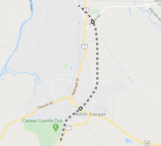
Approximate alignment of the proposed US 7 freeway bypass of Canaan.
Three-state Super 7 plans
From the 1950s into the 1970s, there were plans for extending a US 7 freeway all the way to Bethel or Burlington, Vermont, where I-89 would continue to Canada. Some historians have said the completed US 7 freeway would become I-89, but I've seen no authoritative evidence of that.
In 1959, Connecticut Rep. John S. Monagan introduced a bill to add US 7 and Route 8 to the interstate highway system. This was not adopted.
By 1972, Connecticut DOT officials said they would not favor such a plan, seeing little need for a freeway north of New Milford. However, advocacy groups like the Berkshire - Litchfield Conservancy Council (BLECC) warned in 1973 that piecemeal plans in each state might be a means of sneakily getting the entire plan completed.
In 1977, the Northwestern Regional Planning Agency drafted a plan that rejected freeways for US 7 and US 44 in the region, and called for the terminus design of the planned freeway in New Milford to not create congestion and future highway needs. The plan did account for the possible need for a US 7 bypass for Canaan, however.
Currently, the three-state Super 7 plan is dead.

