Route Numbering and Alignment
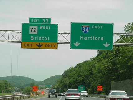
Like "11: New London" or "I-384: Providence", "72: Bristol" is a sign's promise which the freeway has not fulfilled. The Route 72 freeway ends in Plainville, where smaller roads continue west. Photo by Jim K. Georges.
Call Route 72 the Taffy Highway; it has been stretched and snapped over the years. Connecticut has:
- extended the route to Massachusetts then cut it back;
- shifted it from one freeway in Berlin to another;
- divested its eastern portion to three other highways.
All in all, pavement once belonging to Route 72 has been transferred to routes 272, 4, 372, 9, 524, and 3. No part of the original Route 72 exists as Route 72 today.
We won't discuss freeway plans in this section; we'll only cover the alignment changes. Open my historical Route 72 Google Map in a separate window for reference.
Commissioned in 1932, Route 72 originally ran approximately 14.7 miles, from Route 14 (now Route 66) in Middletown to Route 10 in Plainville. Here is its original alignment:
- Berlin St, from Route 66 to Newfield St. This road no longer connects, and was bypassed by Newfield St in 1974.
- Newfield St, northerly to Berlin Rd. in Cromwell. This was formerly SH 346, and now is part of Route 3.
- Berlin Rd, cutting the corner to West St. This is now SR 524.
- Berlin Rd. and Mill St. to Middletown Rd. in Berlin. This was formerly SH 319, and now is part of Route 372.
- Middletown Rd. across the Berlin Tpke. to Worthington Ridge Rd, which was the original US 5 and later became US 5A.
- A short overlap north on Worthington Ridge Rd. to Farmington Ave.
- Farmington Ave. continuing to Corbin Ave. Route 372 joins the original Route 72 alignment at Mill St. and continues with it to Plainville.
- Corbin Ave. to W. Main St. in New Britain.
- W. Main St continuing into Plainville, which becomes New Britain Ave, ending at Route 10.
The road continuing to Bristol and Plymouth, today's Route 372 and Route 72, was part of US 6 at the time. The road continuing north to Harwinton was part of Route 117.
In 1942, US 6 was shifted north to its present location, replacing an old US 6A; and Route 72 was extended westward along former US 6 to W. Main St. in the Terryville section of Plymouth. Old Terryville Rd, near Clark Ave, may be an old Route 72 or an old US 6.
Also in 1942, the Berlin Turnpike was widened to a four-lane divided highway, and Route 72 was realigned along Mill St to cross it at a 4-ramp partial cloverleaf interchange. There are no traces of the interchange now; it was rebuilt in 1962, for a Route 72 freeway, and again in 1989 for Route 9. In favor of this straighter alignment, Route 72 was shifted away from Middletown Rd, the US 5A overlap, and a small section of Farmington Ave. Route 72 was now 23.50 miles long.
On May 1, 1954, Route 72 was extended dramatically, from Terryville to the Massachusetts state line. It replaced the old Route 117 entirely, a road using today's Route 72 and Route 4 to reach Torrington. After a short overlap with Route 4 to West Torrington, it replaced Route 49 (now Route 272) all the way to the state line in Norfolk. Its length was now 56.14 miles, rivaling some of the state's longest routes.
On Nov. 1, 1962, the 3.3-mile Kensington Bypass freeway opened, leading from Route 71A to the Berlin Turnpike. Within the month, Route 72 was moved to that highway, and the former Route 72 became SR 572. Today, the Kensington Bypass is better known as the Willow Brook Connector (today's SR 571) and part of Route 9. More details on this freeway are below.
In 1963, as a result of the state highway reclassification, the bold moves of 1954 were rolled back, and Route 72's northern end was reset to Route 4 in Harwinton. The former Route 49 portion north of Torrington became Route 272. The remainder south of Torrington became part of a realigned Route 4.
Planning and construction continued on the Route 72 freeway in New Britain and Plainville. On Aug. 14, 1969, the "Ellis Street Connector" opened, a 1.04-mile freeway leading northward from Route 72 to Ellis St in New Britain. This portion of future Route 72 was designated SR 507, and marked "To Ellis St" and "To Route 72 East". On Dec. 16, 1969, a section of I-84 opened in the area, including the future overlap with Route 72.
On Feb. 2, 1970, a portion of future Route 72 freeway opened from I-84 to Corbin Ave. This was designated SR 512. On June 16, 1970, this freeway was extended 1,200 feet east to W. Main St.
On Nov. 22, 1978, the Route 72 freeway was completed through New Britain, and absorbed the SR 507 and SR 512 freeway stubs. Old Route 72, including the Willow Brook Connector and Corbin Ave, was given the new designation Route 372.
On Nov. 6, 1980, a 2.5-mile section of freeway opened in Plainville, leading from I-84 exit 33 to a touchdown at Forestville Ave. Route 372 was extended along old Route 72 to the freeway terminus.
The cancellation of I-291 in the area led to some eventual numbering changes in 1989 as other freeway links were completed. A link from I-91 to the Berlin Turnpike became part of the Central Connecticut Expressway, an extension of Route 9, which absorbed all of Route 72 south and east of the 3-way interchange in downtown New Britain.
On Oct. 14, 2011 was possibly the final change for Route 72: the opening of a four-lane extension, partly on new alignment, leading from the freeway terminus in Plainville to Route 229 in Bristol.
Freeway plans
If everything had been built (and never renumbered), the Route 72 freeway would extend from Route 8 in Thomaston, leading through Bristol, New Britain and Berlin, to Route 9 in Cromwell near the Middletown line. All of this east of Plainville was eventually built, though most of it now belongs to Route 9. We'll cover the freeway history region by region.
Kensington Bypass
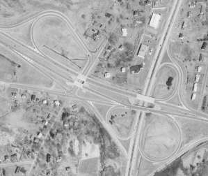
This fractured cloverleaf marked the eastern terminus of the new Kensington Bypass in 1962. When Route 9 was extended, this interchange was replaced. Source: state of CT aerial photo, 1965 (see
original)
The Kensington Bypass was the original name of the 3.3-mile, four-lane freeway leading from Route 71A in Berlin to the Berlin Turnpike. This is now SR 571 (the Willow Brook Connector) and part of Route 9. The Kensington Bypass name fell out of general use in the 1970s.
The Bypass was proposed in the early 1950s (1953 is the earliest citation I've seen) to relieve traffic on Farmington Avenue, a 2-lane road originally part of Route 72. Construction began in 1960, and the highway opened on Nov. 1, 1962. There were originally two interchanges: a partial cloverleaf at Route 71, which remains today, and a fractured full cloverleaf, with access to side streets, at the Berlin Turnpike. (This interchange was completely rebuilt when Route 9 was extended there in 1989.) Shortly after it opened, the Kensington Bypass was designated Route 72.
If you were to extend this freeway along Corbin Ave. and West Main St, you'd have a fairly direct route to I-84. Since that was never done, and Route 72 was instead completed a few miles to the north, you might think that sometime in the 1960s, highway planners changed their minds about where Route 72 should go.
This turns out not to be the case.
In 1959, even before construction began on the Kensington Bypass, city and state planners were proposing the northerly, downtown alignment for Route 72. The "orphaned" half (now SR 571) always served as designed, relieving traffic on old Route 72 in the Kensington section of Berlin.
When the newer Route 72 opened in 1978, the Willow Brook Connector portion became part of the newly designated Route 372. In 1989, when Route 9 was completed from I-91 in Cromwell to the Berlin Turnpike, its designation was extended along Route 72 into New Britain. Route 372 was also redefined to follow Farmington Avenue in Berlin, continuing into Cromwell. The Willow Brook Connector got a new designation - SR 571 - and is signed "To Route 9 South" and "To Routes 71 and 372".
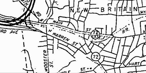
Downtown New Britain
The first proposed freeway for New Britain, circa 1953, was US 6, intended to run easterly near downtown, continuing across Newington to connect with the Berlin Turnpike. The earliest alignment was close to today's Route 72, continuing east near Sunrise Ave. In 1956, the plan was moved slightly north to near where the Slater Road Connector from I-84 would be built. New Yorkers may recognize one of the names on the plans: Robert Moses, who was best known for his New York City planning, though he consulted for many other cities.
Resistance from the city to the original US 6 plan led to a modified plan, where US 6 would skirt New Britain's northwest edge, continuing north to Farmington. (This plan eventually became I-84.) City planners came up with a new proposal in 1959: a relocated Route 72, entering from a junction with US 6 to the west, then turning south in downtown New Britain, to meet with the Kensington Bypass. At the "elbow" where Route 72 made a sharp turn from east-west to north-south, a new freeway for Route 71 would branch off to the northeast.
After the US 6 conflict, the state had been reluctant to discuss highways with New Britain; but in 1960, relations had warmed, and the state agreed that the city plans were generally good. Though it took nearly 20 years to complete, today's Route 72 through New Britain largely follows the 1959 plan.
A 1960 public hearing in Plainville outlined how I-84 would pass through the area. A connector to Wooster and Warren Streets would be constructed as a placeholder for the future Route 72. Within the decade, pieces of Route 72 were opening to traffic.
On Aug. 14, 1969, a 1.04-mile section of freeway extending from the Kensington Bypass to Ellis St. opened. Not yet part of Route 72, this section was designated SR 507, and signed "To Route 72 East" or "To Ellis St."
On Dec. 16, 1969, I-84 opened from Plainville to Slater Rd, including ramps for Route 72 east.
On Feb. 2, 1970, Route 72 was open from I-84 to Corbin Ave (today's Route 372); and on June 16, 1970, the freeway was extended to W. Main St. The remainder was also not part of Route 72 yet, and was designated SR 512.
The changing economy and stricter environmental laws stalled many highway projects in the 1970s, including Route 72. A nearby freeway proposal, I-291, was running into tougher opposition. New Britain politicians and business interests complained about the delays, seeing a completed freeway system as essential for prosperity.
On Nov. 22, 1978, Route 72 was completed through New Britain. The total cost of the project was $142 million. Included in this construction was a 10-lane connector to the proposed but controversial I-291. The connector, closed to traffic, earned the nickname "Highway to Nowhere", and occasionally state workers had to take down unofficial exit signs posted on Route 72 with that nickname.
The "Highway to Nowhere" shed that name in 1986 when it was extended to Route 175. This highway, at the time called SR 506, was later extended to I-84 and is now part of Route 9.
Though guide signs were installed on Route 72 leading motorists to I-291 (and covered with plywood as a measure expected to be temporary), I-291 was cancelled less than 6 months after Route 72 opened.
The completed Route 72 freeway immediately relieved traffic on Corbin Ave. and other New Britain streets. However, the added capacity led to new congestion in Plainville, where Route 72 continued as a surface street. Fortunately, the state had plans for Plainville as well.
Plainville
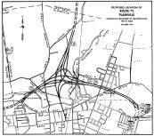
In the 1960s, this interchange of the 10 and 72 freeways with a downtown Plainville connector was planned. Drawing is from 1970. (see
larger image)
By 1960, state plans for Route 72 in Plainville were already mature. A freeway branching westward from a curve in I-84 would carry Routes 72 and 10 for about a mile; then a new Route 10 freeway would turn north, while Route 72 continued west. The freeway would cross present-day Route 72 before entering Bristol.
The Route 72/10 interchange was unpopular among many residents and was, along with the Route 10 freeway, cancelled.
A six-lane, 1.5-mile segment of Route 72 was built in 1975, extending just beyond Route 10. However, it was not opened to traffic right away. In 1976, the state's latest plan was to continue the route as a two-lane road (bowing to budget issues) with an interchange near Hooker St.
On Nov. 6, 1980, a four-lane extension to Forestville Avenue opened, along with the 1975 section. To minimize right-of-way-impacts and costs, the newer section was built as four lanes instead of six, with a much narrower median. The transition between these sections is easy to spot. The cost of the Plainville work was $10.5 million.
The interchange with Route 177 did not open when Route 72 did. Work on that $500,000 half-interchange started in January 1981, and completed Jan. 21, 1982.
After this opening, Route 372, which was created in 1978 to designate old Route 72 in New Britain, was extended for the same role in Plainville.
Bristol
Bristol residents may have been wondering whether I would get around to covering their city, or whether I'd forget, like the state did. Just kidding.
Bristol, a city of 60,000, is Connecticut's largest city without freeway access. That a freeway - Route 72 - had been proposed 50 years ago and never built adds to the sentiment of neglect some citizens and officials feel from the state.
Route 72 would have passed close to the south end of the city center, elevated in some parts, as it continued toward Route 8 to the west, and I-84 to the east.
In 1961, the proposed Route 72 was to run south of Pine St, cross Middle St and Mountain Rd, and end near Memorial Blvd. A future extension would continue to Thomaston. In July 1961, the west Bristol plan was laid out in more detail, including planned interchanges near Downs St, Church St, Route 69, and Route 72 at the Plymouth town line. I have tried to reconstruct this route from newspaper articles in this map.
In 1963, the city proposed moving Route 72 southward to the South Mountain section, to which the state agreed; it was estimated that construction was at least 7 years away.
In 1969, three alternatives were under study:
- Plan A, a northerly route, from King St through or near St. Thomas Cemetery, over Chippens Hill to the Plymouth town line;
- Plan B, the 1961 proposal through the city center;
- Plan C, the new favorite, the southerly route. From Pine St, the road would continue near East St, then near Wolcott Road and Fall Mountain to Waterbury Rd.
Many citizens, business owners and officials continued to press for the highway. In 1968, a contest was held for high school students to design bumper stickers, posters and lapel pins in support of the highway. The slogan "Route 72 by '72" took hold.
By 1975, the project was still stalled, and the state lowered its priority because of economic conditions. It remained in the state's Master Transportation Plan: a 6.9-mile freeway extension from I-84 in Plainville, at a cost of $120 million.
In 1976, Bristol advocates called for a committee with representation from all 8 towns along the route to press for completing Route 72. This led to the "Route 72 NOW" committee, which promoted the route at the local and state level.
In 1977, the state proposed an interim 2-lane extension for Route 72 into Bristol; the Route 72 NOW committee countered with "how about 4." That year, the DOT requested $94 million to extend the freeway westward.
The state even acquired some property in Forestville and Plainville for freeway right-of-way in the late 1980s. But in 1992, the freeway proposal was tabled.
In 1996, a new plan was aired: extend Route 72 into Bristol as a four-lane boulevard on new alignment, and then use widened city streets to create a continuous four-lane highway to Route 229. A 1.1-mile section of boulevard opened on Sept. 27, 2010.
Bristol - Route 72 as an Interstate Spur
In the mid-1970s, ConnDOT had investigated adding 72 to the interstate system, to get the 90 percent funding, including talking to FHWA.
By 1977, the Route 72 NOW committee was also recommending the interstate option. I found no record of the designation anyone had in mind, but a spur number from I-84, such as I-384, would have been likely. (Today's I-384 was not designated yet.)
In January 1978, the committee got some bad news: chances were very small that the $200 million needed to finish the highway would be approved; and chances were also slim that it would be accepted as an interstate spur.
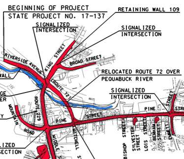
This portion of the project map for Route 72 into Bristol shows a shared alignment along widened Pine Street, and a new bridge over the Pequabuck River. Route 72 now crosses Route 229 at a four-way intersection, replacing a "dogleg" overlap. The new roadway fully opened on Oct. 14, 2011.
Bristol: what was done
The most recent improvements to Route 72 were a long time coming: to extend a four-lane boulevard from the end of the freeway in Plainville to Middle Street in Bristol. The extension has no interchanges, and a few at-grade intersections. A 1.1-mile section of boulevard opened on Sept. 27, 2010; the rest of the project was open to traffic on Oct. 14, 2011.
On Nov. 30, 2011, the old alignment of Route 72 along E. Main Street and Broad Street became unsigned SR 500A (no relation to SR 500), and was later turned over to the city.
The $31 million, 2.4-mile project was approved by ConnDOT on May 31, 1996, and greenlighted by the FHWA in 1997 (after four years of environmental study). The scaled-down plans (compared to the original freeway plans) are said by a local newspaper to have "saved the project." A $4.5 million infusion of federal funds in June 1998 also helped.
The relocated Route 72 continues west from the freeway terminus through a residential neighborhood to Yard Pond; after crossing the pond, it follows Pine Street, veering north at Mitchell Street, and crossing the Pequabuck River on a new bridge to connect to Middle Street across from Riverside Avenue. (An earlier variant would have had Route 72 follow Pine St to its end, and overlap with Route 229.)
The eastern half is a sunken boulevard (as much as 17 feet), with a 12-foot raised median separating opposing directions. Several streets intersecting with Pine Street are cut off, including Broad Place and Sylvester, Benham, Balsam and Evergreen streets. The road intersects Central and Todd streets at-grade.
The project included eight bridges, an additional mile of turning roadways and interchanges, and three miles of local and state roads.
The project is 80% federally funded, and was to begin in spring 2002. However, difficulties in obtaining right-of-way has caused the projected start date to slip. Work began in 2007.
Land-use decisions anticipate new highway
Meanwhile, some Forestville businesses have floated the idea of demolishing some former retail buildings at the intersection of Central, East Main and Broad streets on present-day Route 72, and realign the intersection to improve traffic. The support is not unanimous, but has a majority. The state contended that the new Route 72 would alleviate the problem.
In late 2002, city officials started working on land-use rules for the new street layout that will result from the Route 72 extension. "It's a new road. You'll never have this opportunity again," said City Planner Alan Weiner, quoted in the Bristol Press.
Plymouth and Thomaston
There's not a lot of detail about Route 72's proposed path through these towns to Route 8. It probably would have stayed south of US 6.
In March 1961 a bill was submitted to the state assembly calling for the upgrade of US 202 to a freeway, from Southbury through Watertown, Thomaston and Bristol to Farmington. (Until 1974, US 202 overlapped with US 6 between these towns.) This proposal was not adopted, though the Thomaston to Bristol route coincides with the general Route 72 proposal in the area.
In 1962, provisions were being included in the layout for the future Route 8 freeway for a Route 72 connection.
In January 1967 a bill was introduced to extend the Route 72 freeway from the planned Bristol segment to Route 8, which was now under construction. In February 1969, the state's proposed $250 million highway bill included $3.5 million for engineering costs for Route 72 from Route 8 to the Plainville town line.
In March 1969, planners were examining Route 72 alignments north and south of Terryville. The cost from Route 8 to the Bristol city line was estimated at $40 million.
In March 1970, businessmen in Thomaston and Plymouth asked the state to continue extending Route 72. They understood the route was south of US 6. At this time, though, the DOT said they currently had no route in mind.
The proposal was never cancelled as decisively as, say, I-291 in the area. In 1981, Thomaston candidates were still hoping to extend Route 72 to Route 8. And in 1998, US 6, the main street through Plymouth, was getting attention as the state and town investigated how to improve traffic flow. Plymouth officials were said to prefer extending Route 72 westward to Route 8 instead, as a parallel 72 could pass through open land in the southern part of town and relieve traffic from US 6.
Although the alignment of Route 8 in Thomaston was reported to provide for a future Route 72 connection, no stub ramps or rock cuts are visible in this area.
Cromwell - east of I-91
Route 72 no longer extends to Cromwell, as a freeway or surface road. Yet the original plan for Route 72, as a freeway from Route 8 to Route 9, included several miles that are now part of Route 9.
The segment of Route 9 east of I-91, which opened in 1969, had been referred to for years as the Route 72 relocation. Part of the reason for this: in the late 1950s, the planned freeway for Route 9 was not intended to veer northwest toward Berlin. Instead, it would continue north and east of the Silas Deane Highway (Route 9 at the time), skirt Old Wethersfield at the Putnam Bridge approach, and meet Route 15 just across the Hartford city line, near Brainard Airport. Route 72 would have met Route 9 near the Connecticut River, in the south end of Cromwell.
A few changes took place in the early 1960s. The line for I-91 north of Meriden was refined, and situated well east of the Berlin Turnpike. In Rocky Hill and Wethersfield, I-91 took over the original late 1950s relocation plans for Route 9. Instead of continuing north through Cromwell to meet I-91 in northern Rocky Hill, it made more sense to let motorists follow "Route 72" a few miles inland to connect with I-91. In late 1965, the state announced its numbering plan for the Route 9 freeway; the Cromwell portion called "relocated Route 72" was to become part of Route 9. (The Silas Deane Highway, old Route 9, would have become Route 18).
For the next few years, this portion of Route 9 was occasionally called Route 72; the week before it opened, the Hartford Courant remarked that "Part of the road is now called Rt. 72. But when it opens, the road will be called Rt. 9."
On May 29, 1969, the 3.7-mile segment of Route 9 opened to traffic, leading from a 3-level interchange at I-91 to Main St in Cromwell. The ramps at West Street (today's Route 372) were not complete yet, and opened later.
Cromwell - west of I-91
For years after the Route 9 opening in 1969, cuts in the rock and earth told motorists that a fourth leg of this interchange was planned, to connect with the 1962 portion of Route 72 starting at the Berlin Turnpike. A four-lane freeway extension was approved in 1971, and an Environmental Impact Statement (EIS) was approved in 1975, but work did not begin for more than a decade. By 1974, planners were also calling this segment of future highway Route 9; that meant Route 72 would be cut back to the Berlin Turnpike, if not further.
As it turned out, by the late 1970s the DOT reasoned that it made sense to first determine the outcome of I-291 in the area before proceeding with the Route 9 extension.
What prompted the extension of Route 9 all the way to I-84 in Farmington was the cancellation of I-291 in March 1979. A less ambitious alternative was already in place: the Central Connecticut Expressway. This highway would thread together existing routes (72, SR 506, and the "Stack" in Farmington) along with some new construction to form a connector from I-91 to I-84. The entirety of the Expressway would be part of Route 9.
The new segment in Cromwell and Berlin opened in late 1989.


 "Route 72 Extension" appears on a 1960 Highway Department planning map.