Commissioned in 1932, Route 71 originally extended from Route 72 (now Route 372) in Kensington to US 5 or US 5A in Hartford. (I don't have a definite answer on the northern terminus). Its route, from south to north:
- New Britain Ave. (part of today's Route 71), from Farmington Ave. to Stanley St. (part of which is now called Veterans Dr)
- Stanley St., continuing north to Hartford Rd. The construction of Route 9 severed Stanley St. in two locations: one at South St., where part of Stanley St. is now called Veterans Dr.; and at North St., where Stanley St. resumes on the opposite side of the freeway.
- Hartford Road (also part of today's Route 71), which becomes New Britain Ave. at the Farmington town line
- New Britain Ave. continuing east and northeast into Hartford, ending at Webster St. or Maple Ave.. Today, New Britain Ave. is divided among Route 71, Route 173, SR 530, and city maintenance.
Early changes in West Hartford, Berlin
In 1934, US 6A was designated along the east-west portion of New Britain Ave. in West Hartford. Route 71's northern end was moved back to the rotary (which is no longer there), where South Road now meets Route 71 at Corbins Corner. Later, US 6A became US 6.
Also in 1934, Route 71 incorporated old SR 751 in Berlin; but I have no information on what street that was.
Extended to Meriden
In 1935, Route 71 was extended southward to Meriden, along a road formerly known as Cat Hole Pass Road, or Cat Hole Road. This newly paved 7-mile road shortened the trip from New Britain to Meriden by several miles. In an October 10 dedication (though the road had already been in use for a few weeks), officials remarked that the road would probably be renamed to Chamberlain Highway, to honor two brothers prominent in state history (one of them a governor) who often used the road. That did take place (and it's difficult to imagine any homeowner or business owner preferring the "Cat Hole" name.)
Route 71's original journey through Meriden differed from where it is today. From south to north:
- Hanover Ave., from Old Colony Road to Main St (today, this is part of Route 70)
- Hanover Road and Bradley Road, to West Main St (today, locally maintained)
- Chamberlain Highway (today's Route 71), continuing to existing Route 71
Other changes
On Sept. 11, 1962, Route 71 was moved in Meriden to follow its current path, and extended south over former US 5A to end at US 5 in Wallingford.
In 1964, the section of New Britain Ave at Corbins corner was widened to 4 lanes divided. In 1974, the divided section was extended south toward New Britain, coordinating with the opening of WestFarms Mall.
In 1969, when I-84 was completed, US 6 in West Hartford and Hartford was moved to overlap with I-84. Route 71 was extended east along New Britain Ave, recapturing some of its 1932 alignment, to end at Route 173, which had also been extended west along New Britain Ave. and north along S. Main St. to end at I-84.
In 1976, Route 71 was moved from Stanley St. to its current alignment. The Route 9 freeway would soon sever Stanley St. in two places.
Proposed removal south of Route 372
In 1960, the recommendations for the state's road reclassification included dropping the portion of Route 71 between Route 71A and today's Route 372 from the state highway system. Route 71A would have remained, all the way up to Main Street in New Britain. Route 71 also would have remained north of Route 372 (Farmington Avenue), which was SR 572 at the time. This proposal was rejected in 1962. As the recommendations addressed roadways only, not route numbering, we can only guess how numbering would have changed if it went through. At least a portion of Route 71A would become Route 71. But a dangling portion of Route 71, north of Farmington Avenue, might have received a different number.
Freeway proposals
Several variations of a Route 71 freeway from New Britain to West Hartford were proposed in the 1950s and 1960s. Though it may not be apparent, part of the proposed Route 71 freeway was actually built: this is now Route 9 leading north from Route 72 into Newington. However, it was never signed as Route 71.
In Nov. 1954, State Highway Commissioner G. Albert Hill announced the proposed alignment of a new Route 71 freeway. Starting at a proposed US 6 freeway just north of Dix Ave. in Newington, the freeway would cross Cedar St (Route 175) at a diamond interchange, then continue north to a proposed East-West freeway, southeast of Corbins Corner in West Hartford. The Route 71 freeway would have four 12-foot lanes with a 10-foot median. Both interchanges at the termini would be 3-level directional T form, with left exits. The US 6 freeway was cancelled around 1957, making the Route 71 plan obsolete, but the East-West plan became today's I-84.
Circa 1957, the modified Route 71 freeway was to proceed roughly from Allen St. in New Britain, eastward to the Newington border, then north along the town line to meet the future I-84 at Corbins Corner.
By 1959, the city of New Britain had a plan for the Route 72 freeway, to enter downtown from the south, and continue to the west; this was actually completed in 1979, though the southern leg later became part of Route 9. From the downtown bend in Route 72, the Route 71 freeway would extend northeast to Newington.
The city was developing these plans, as the state, having its US 6 proposal rejected, was reluctant to discuss further plans with the city. By June 1960, however, state and city were talking again, and the state said the city plans were "generally good." There was opposition from the Buena Vista district, where residents had earlier faced displacement by the proposed US 6 freeway.
In 1961, plans for I-291 were taking shape; Route 71 would now connect I-291 to the downtown bend in Route 72. Part of this was constructed, but left closed to traffic, in 1979 -- the same year I-291 in the area was cancelled.
In 1963, the state announced an extended plan for Route 71: the four-mile, four-lane freeway would start at the Route 72 bend in New Britain, cross I-291, and end at a proposed Cedar Ridge Connector (SR 504) in Hartford. This was scheduled to be built "sometime after 1975", which in 1963 meant Route 71 was nowhere near the top of the state's priority list.
No freeway plans are active now for Route 71. But if you drive Route 9 from New Britain to the "Stack" at I-84, you'll follow the approximate corridor for the early plans. You'll also skip the congestion and red lights along the parallel surface stretch of Route 71.
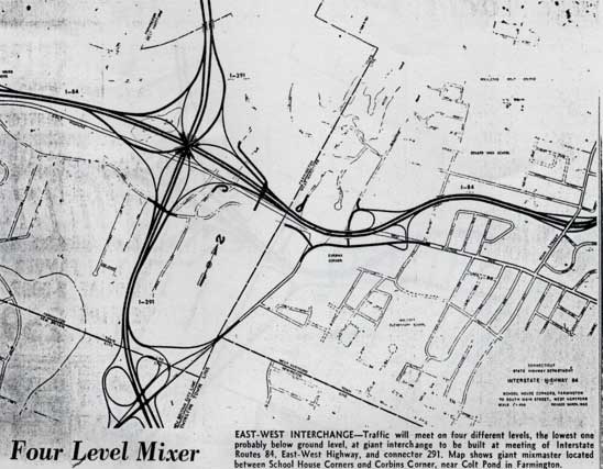
Diagram of proposed I-84/291 interchange, by Connecticut Highway Department, as shown in Hartford Times, August 2, 1963. Note the displacement of Route 71 (New Britain Ave.) by the I-84 alignment, and the 7-ramp interchange proposed at Route 71 and I-291. A simple diamond interchange opened there in 1992, as part of Route 9.


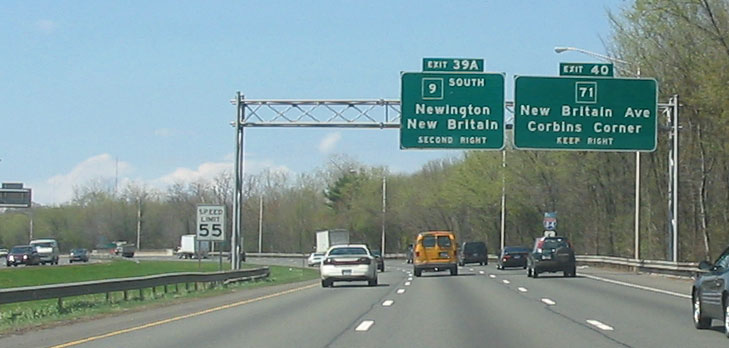 A guide sign on I-84 westbound announces upcoming exits for Route 71 and the Route 9 freeway.