Location Changes
In late 1931, as the state planned its 1932 renumbering, Route 69 was originally to continue through Waterbury to end at US 6 in Watertown. Instead, that road became Route 73.
Route 69 was commissioned in 1932, and incorporated the earlier state highways numbered 348, 199, and 172. Its original alignment was a 17-mile route from Route 63 (Route 67 at the time) in New Haven to E. Main Street (Route 14 at the time) in Waterbury:
- Whalley Avenue and Litchfield Turnpike in New Haven, Woodbridge, and Bethany (today's Route 69)
- continuing on Litchfield Turnpike to Amity Road at Cheshire Road (Route 63 and Route 42). Most of this segment is no longer a state road; a small part is divided between Route 42 and SR 703.
- a short segment of Cheshire Road (Route 42)
- an unknown north-south road, no longer open, through the forest near the New Naugatuck Reservoir, connecting to today's Route 69 across from Talmadge Hill Road. That right of way is visible from Route 69, but it appears that trespassing is forbidden.
- today's Route 69 (New Haven Road and Waterbury Road), continuing through Prospect
- Hamilton Avenue in Waterbury to E. Main Street
The northernmost part of Hamilton Avenue, and the original Route 69, is gone: replaced by an extended Union Street and the Brass Mill Center.
In 1932, today's Route 69 continuing to Bristol was called Route 119. The road to Burlington was not numbered.
In 1934, concrete was laid on 1.5 miles of Route 69 near Prospect, opening a route between Waterbury and New Haven that was nearly five miles shorter than nearby routes. This segment of Carrington Road and New Haven Road replaced the mystery road through the forest near the reservoir.
Also in 1934, Route 69 was extended to Route 72 in Bristol, incorporating Route 119. After a short eastbound overlap with E. Main St, Route 69 followed Wolcott St. into Bristol. This is slightly west of its current alignment leaving Waterbury. The extension increased Route 69's length to 27.60 miles.
The original alignment of Route 69 in Wolcott was more serpentine than today, following Munson Road, a short stretch of Center Street, Minor Road, and Bound Line Road. The segment of Wolcott Road between Bound Line Road and Woodtick Road had more curves than it does today. Around 1935, Route 69 was moved to 7.2 miles of new and realigned roads to the path it takes today. Signing of Route 69 here, although official in 1934, might have been arranged with the opening of the new road.
In 1935, the small segment of Center Street on former Route 69 became SR 522; about 30 years later, SR 522 would be expanded into signed Route 322.
In 1949, an act was submitted in the General Assembly to add Burlington Avenue (Bristol) and Milford Street (Burlington) to the state highway system. Part of Milford Street was already SR 787. These roads would later, in 1962, be added as part of Route 69.
Interesting: in 1953, a bill was submitted to turn over Burlington Avenue in Bristol, which had not yet become part of Route 69, back to the city. I don't know what the SR number was at the time.
In 1953 or 1954, Route 69 was extended south to Route 10 in New Haven, as part of a triple overlap (Routes 63, 67, and 69). This was likely done so that more northwestern towns could follow a single route into New Haven. Route 69 was now 29.83 miles long, including a 2.44-mile overlap with Route 67.
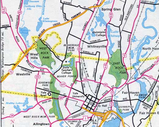
There's some off-topic material in the map, but it's fun to include. The road marked "69" ending at Sherman Ave (Route 10) is actually routes 63, 67, and 69. Ansonia Rd. and Fountain St. should be marked as Route 114. And, Route 17 and Route 80 are longer than they are today.
In 1962, Route 69 saw several changes. In New Haven, Routes 69 and 67 were removed from the overlap with Route 63. In Waterbury, Route 69 was moved from Wolcott St to the Silver Street Expressway and Woodtick Rd. In Bristol (August 1962), Route 69 was extended along old SR 787 to Route 4 in Burlington. These changes brought the route to its current location and length.
In 1963, the Waterbury Area Transportation Study called for relocating Route 69 to a straighter north-south route across I-84 with a new high-capacity interchange. The study also recommended widening and improvements for Route 69 in southern Wolcott.
Silver Street Expressway
An expressway opening in Waterbury in 1949 sounds like the start of something big: perhaps an old section of I-84? Instead, it's an 0.1-mile connector, replacing Silver Street, from Hamilton Avenue to E. Main Street, bordering Hamilton Park. It was apparently a divided highway in 1949, and referred to as "the first link of the new Waterbury Expressway", but is now 4 lanes undivided. An overpass over Hamilton Park Road provides a small expressway-like experience. The Expressway became part of Route 69 in 1962.
Scenic Route applied for
In March 2000, officials in Woodbridge and Bethany proposed making part of Route 69 a scenic route; the state reviewed the application, but declined it. The portion reviewed extended from Bond Road in Woodbridge to Route 42 in Bethany.
Realignment proposed in Waterbury
In 2003, Waterbury planners proposed moving Route 69 closer to its original alignment north of Meriden Road. Instead of following Woodtick Road and Stillson Road to meet Wolcott Street, the proposed realigned route would follow Manor Road to intercept Wolcott Street one mile to the south.
Business owners complain that present-day Route 69 bypasses a large retail area on Wolcott Street, and some customers are reluctant to leave Route 69, or get lost doing so. Residents along Woodtick Road don't like the additional Route 69 traffic. Moving Route 69 seemed like a good idea, and the recommendation was added to the city's plan of conservation and development in 2005.
Today, however, Route 69 remains where it is. Some reasons against the move include the increased congestion a northbound left turn onto Manor Road would cause; and the local funding (a few million dollars) needed to improve the new alignment to state standards. I haven't seen anything on this story since 2005.

