On
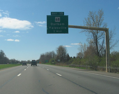
I-91 southbound, approaching Route 68 in Wallingford. Photo taken April 2004 by Kurumi.
Commissioned in 1932 from the old State Highway 325, Route 68 originally extended only 7.13 miles from Route 63 in Naugatuck to Route 70 in Cheshire. Two unsigned state roads, SR 730 (Church Street) and SR 607 (Barnes Road), continued through Wallingford to Durham.
Improving Mooney's Crossing
At the time, SR 730 crossed the New Haven Railroad at grade ("Mooney's Crossing") to end at US 5. SR 607 continued east from US 5 about 500 feet south of the SR 730 terminus. (Both roads were added to the state highway system on Sept. 1, 1957.) This layout was unsafe and handled east-west traffic poorly because of the dogleg on US 5.
In 1961, delegates from Wallingford, carrying placards like "Stop the Slaughter at Mooney's," pressed legislators to include a fix for the crossing in the state highway program. Later that year, the state unveiled a plan to bridge the railroad and connect the two roads. In 1962, officials noted that the intent was not to create a major artery, but to make the existing road safer. Project completion was expected in late 1964.
Several articles in the Meriden Record-Journal referred to Church Street and the overpass as "Route 730", a designation that was never signposted, but readers appeared to take that in stride.
The Mooney's Crossing overpass opened on Oct 5, 1965, but some connectors to Barnes Road would open a few weeks later. Motorists from the east had to use North Main Street Extension and Ives Road to get to US 5. City officials unsuccessfully lobbied the state to extend the overpass east, over North Main Street.
Extension to Durham, and I-91
In 1964, possibly to give Yalesville and Durham better access to the planned I-91, the Route 68 designation was extended over SR 730 and SR 607 to Route 17 in Durham. The state indicated that signing was to take place when the Mooney's Crossing project (above) was completed in 1965. In 1966, I-91 opened to traffic in the area, including an interchange with Route 68.
The "Super 4" segment in Wallingford
On Aug. 24, 1973, a 2.5-mile segment of Route 68 was relocated in Wallingford, from the new US 5 overpass at Mooney's Crossing to I-91. Most of the new road was four-lane, undivided, and access controlled (almost a Super 4). Several parts of the former Route 68 exist as Barnes Road, which the new highway parallels. The state labeled these parts as SR 752A in 1973, and turned them over to the city in 1974.
Other changes
In Cheshire, Route 68 was straightened out west of where it crosses Broad Brook Reservoir in 1966. The original route followed a sharp curve north, closer to the shore.
In eastern Wallingford, near the Tilcon plant, a mile of Route 68 was realigned in 1968, replacing a narrow railroad overpass and straightening some curves. Public hearings were held in 1965 for this project. An old segment of the route still exists, also called Durham Road, to the north of the new Durham Road.
In 1971, the state proposed relocating 1.4 miles of Route 68, leading easterly from the I-91 northbound entrance to the railroad tracks near North Branford Road. The 2-lane highway would have been located on new alignment, with limited access, north of current Route 68 on Barnes Road. However, this proposal was never implemented.
In 1986, Wallingford officials called for a traffic study for the Route 68 corridor.
In 2002, a one-mile segment from Williams Road to Leigus Road was widened (mostly four lanes with turning lanes), and two side streets were made into cul-de-sacs to decrease the number of access points. This widening was first suggested in a 1988 study of Route 68 between Durham and Cheshire.
In 2004, the interchange with I-91 was slightly realigned, with the overpass widened to five lanes, to add left-turn lanes onto the entrance ramps. This was supposed to finish in fall 2003, but a structural problem, requiring redesign and reordering of bridge supports, delayed its completion.
Proposed freeway
The state once had grander plans for Route 68: a freeway, leading from a proposed Route 10 freeway in Cheshire across Wallingford into Durham. This was in the category of "proposed highways for future traffic needs", and was never constructed. In fact, I haven't seen evidence of any public hearings or detailed design for the Route 68 freeway itself.
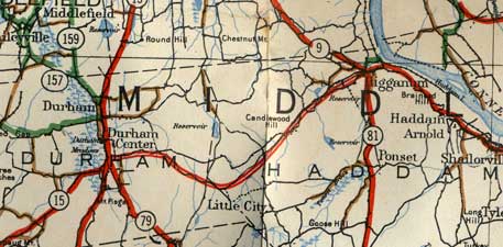
This scan from the 1938 official state map shows the proposed trunk line route leading from Durham to Higganum in Haddam. The route follows Higganum Road and Candlewood Hill Road. (Also note: Route 15 (now
Route 17) and old
Route 159 (now a local road))
Proposed Extension to Haddam
In 1935, the state assigned Route 180 to a proposed trunk line route from Durham to Haddam. The 1938 official state map shows the proposed route. Route 180 was never built; if it had been, it would be a natural extension of Route 68.
In 1969, the Mid-State Regional Planning Association proposed an extension of Route 68 eastward, as an arterial route (non-freeway) on new alignment:
Extension of Connecticut Route 68 (which now terminates at Route 17 in Durham) to Haddam provides the Region with a southern east-west road. Construction of this arterial would carry traffic which must now go north onto Randolph Road (Route 155) through Middletown in order to get to the State expressway network going east or south.
Proposed widening declined
In 1998, though congestion and a commercial boom in Wallingford had touched off calls to widen Route 68 near US 5, the state said it would not be widened in that area.

