Route 2A was conceived as a bypass around downtown Norwich, and still serves that purpose, but today it's the gateway to the Mohegan Sun and Foxwoods casinos. It was one of the first state highways to have its exit numbers converted from sequential to mileage-based.
Route 2A profile
Overlap with I-395 between the 2/395 interchange and exit 9 (formerly 79A), where Route 2A splits off. This overlap is barely signed at all; only on Route 2 eastbound do guide signs mention that I-395 southbound also carries Route 2A southbound. As far as most motorists are concerned, Route 2A begins at exit 9.
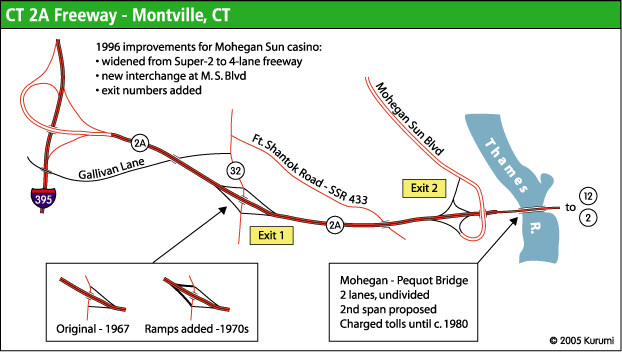
Four-lane freeway in Montville, from I-395 exit 9 to just east of Mohegan Sun Blvd.
Two-lane undivided "Super 2" continuing on the Mohegan-Pequot Bridge over the Thames River, ending at Route 12.
From 1953 to 1957, another Route 2A existed, in Glastonbury and East Hartford. When the new East Hartford - Glastonbury Expressway (Route 2 and Route 17) opened in 1952 and 1953, the former alignments had short-lived designations as routes 2A and 17A. Route 2A extended about 3 miles, leading from Route 17 in Glastonbury, via New London Turnpike and Main Street, to Brewer Street in East Hartford, which was the northern terminus of the expressway. (This is now the Main Street exit on Route 2).
CT 2A History
Poquetanuck Road
The part of Route 2A between Routes 12 and 117, Poquetanuck Road, dates back to the early 20th century. In the late 1920s, it was called state highway 179; in the 1932 renumbering, it became unsigned SR 664.
In 1949, Poquetanuck Road was incorporated into Route 27, the Colonel Ledyard Highway. In 1963, when Route 27 was truncated, it reverted to an unsigned route (SR 640); and on Dec. 1, 1967 Poquetanuck Road became part of Route 2A.
The Route 2A Freeway
In 1961, the state General Assembly issued an Act providing for the construction of the Thames River Bridge and approaches, from the Connecticut Turnpike (now I-395) in Montville and Route 12 in Preston. Planning was completed in May 1962, and the "Route 2A" designation was already in mind for the new road. Completion to Route 12 was expected in 1965. The highway was planned to extend to Route 2 by 1972.
Route 2A opened on Dec. 1, 1967 as a "Super 2" freeway: only one lane in each direction, but access fully controlled. There were two interchanges: a trumpet at the Connecticut Turnpike (which survives today) and a half-diamond interchange at Route 32 (details below). After passing a toll station and crossing the Thames River, the new highway ended at Route 12. Route 2A then continued along existing surface roads, including Poquetanuck Road, to end at Route 2 and Route 117 in Preston.
Completing the Route 32 interchange
The original Route 2A interchange at Route 32 was a half-diamond, with ramps to and from the east. This decision was made under some controversy.
A full interchange had been considered, but the state's Bond Declaration for the Connecticut Turnpike, at the time a toll road, prohibited adding access points that could decrease toll revenue (unless total revenue exceeded debt service by 20%). A full interchange at Route 32 could enable motorists to easily bypass the Montville toll station, just south of the Turnpike/Route 2A interchange.
In May 1967, several months before Route 2A opened, a state senator submitted a bill to provide for a full cloverleaf interchange at Route 32.
A few years after Route 2A opened, studies showed that while the bridge had not yet appreciably relieved traffic through Norwich (one of the design goals), traffic on Route 32 had surged, partly because of poor access to the underused Turnpike to the west. In 1971, completion of the interchange at Route 32 was recommended. On August 30, 1974, new ramps were opened to make a complete diamond interchange.
The Mohegan - Pequot Bridge
The two-lane, 1435-foot Mohegan - Pequot Bridge crosses the Thames River at a height of 75 feet. It opened on Dec. 1, 1967, along with Route 2A. A toll station on the west side of the river collected tolls (15 cents for autos) in both directions.
Though Route 2A was an alternate for Route 2 in Norwich, planners hoped the new bridge would also relieve traffic to the south: namely the narrow, congested Gold Star Bridge over the Thames River on I-95, a notorious bottleneck until a second span was opened in 1973.
The bridge's original name was the Montville - Preston Bridge; in 1966 a state representative, honoring the request of a Mohegan man, submitted a bill to name the bridge after the Mohegans and Pequots.
In the first months after its opening, complaints about the Mohegan - Pequot bridge poured in. The lightly-traveled route did not relieve Gold Star Bridge traffic as proponents hoped; and Route 2A drivers disliked the bridge's narrow, sparsely lit, undivided roadway. Drivers buying commuter books of toll tickets, good only for a month, were often unable to use all the tickets before they expired. Toll revenue was so light that critics wondered if the bridge would ever be paid off, and some called it a "white elephant."
On Oct. 1, 1968, the state changed the ticket book prices and shelf life to make the bridge more attractive. The expiration date was raised from 30 days to 60 days; and the price dropped from $3.50 for 42 tickets (8.5 cents each) to $2 for 40 tickets (5 cents).
Officials continued trying to entice more traffic across the bridge. The single-crossing 15-cent toll was cheaper than the 25-cent toll on the Connecticut Turnpike. During Memorial Day weekend in 1972, ConnDOT and the state police established a "Route A" bypass for I-95 in the area, using Route 52 (now I-395), Route 2A, and Route 2.
Cash flow remained a problem. The tolls were intended to repay its $7.5 million cost, but for all except two break-even years, the bridge ran a deficit: more was spent on operating the toll booth than was collected in tolls. In 1976, after a raise to 25 cents, operating the bridge still cost the state $45,000.
In 1977, the state legislature's Transportation Committee joined Norwich area officials in calling for removing tolls from the bridge. On Oct, 1, 1980, the bridge was made toll-free.
Bridge and freeway names result of compromise
You won't find the Clifford C. Oat Highway on any map; or, for that matter, the Fort Shantok Connector. Those were preliminary names for the Route 2A freeway. The Fort Shantok Bridge became the Mohegan - Pequot Bridge, whose name did persist. A compromise for the newer names was worked out by state and town officials in May 1967.
Proposals to extend Route 2A
In 1963, the state was already planning for Route 2A to extend to Route 2 near Brickyard Road (west of Route 117) in Preston on new alignment. This was expected to be complete by 1972. When Route 2A opened in 1967, funding issues led to a temporary end at Route 12 for the new highway.
In 1968, State Sen. William B. Stanley asked the DOT to accelerate planning for a Route 2A extension, reasoning that a complete highway to Route 2 would make the Mohegan - Pequot Bridge more attractive and help relieve Gold Star Bridge traffic.
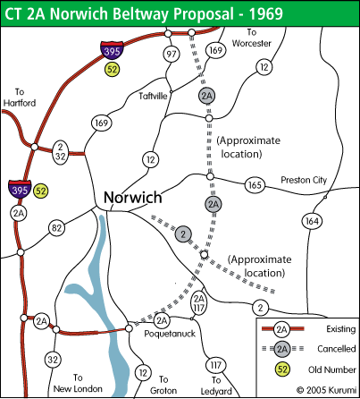
In 1969, the state proposed extending Route 2A as a circumferential northeasterly to Route 52 (now I-395) east of Norwich -- a mirror image of the northwesterly bypass Route 52 made. The $22.5 million project would provide interchanges at Route 12, a proposed Route 2 freeway in Preston, at Route 165, at Route 12 again, and at Route 52 east of Route 97.
At the same time, the state was planning to have the future Route 78 extend northwest from I-95 at Stonington to the vicinity of the Mohegan - Pequot bridge; conceivably today's Route 2A freeway would have been part of a longer Route 78.
However, 1970s funding problems and highway opposition defeated the complete bypass and Route 78 plans, and even the continuation from Route 12 to Route 2 in Preston. In 1975, the state notified the Southeastern Connecticut Regional Planning Agency that because of bonding limitations, the next 20-year DOT master plan would have Route 2A as only a "Super 2" (two lane undivided highway) from Route 12 to Route 2, and Route 78 would also be scaled back to two lanes between Route 2 and I-95 in Stonington. As it turned out, neither segment was built at all.
Casino Traffic forces upgrades in 1996
"This is the biggest thing I've ever done... Normal construction takes normal time, but this, we're working 60 hours a week. After 40 hours, yes, we pay workers time and a half."
The Mohegan Sun Casino, which opened in October 1996, required a fast-track upgrade of Route 2A between I-395 and a new four-lane access road. The casino builders (the Waterford Hotel Group) funded the $29 million, 9-month upgrade: widening Route 2A to four lanes in that section and adding an interchange at Mohegan Sun Boulevard. Contractors broke ground in January 1996 and finished by October. During this upgrade, exit numbers were added for Route 32 and Mohegan Sun Boulevard.
CT 2A Future
Note: a flurry of planning activity around 2000 for Route 2A has mostly not panned out; the "future" section here will likely move to "history".
Second span and Route 2A bypass proposed
The Mohegan - Pequot Bridge, carrying Route 2A over the Thames, symbolizes the forces at work and controversy over the highway's future. The Mohegan Sun Casino (opened 1996, next to Route 2A) and the Mashantucket Pequots' Foxwoods Casino (opened 1992, on Route 2 in Ledyard) have generated enough traffic to lead the state to think about widening Route 2A across the river, and building a new four-lane bypass leading to Route 2. ConnDOT says the bypass would reduce congestion and traffic accidents on existing Route 2A.
ConnDOT issued a Transportation Improvement Study for routes 2, 2A and 32 in April 1999, listing six alternatives for highway upgrades. The one adopted includes the Route 2A upgrades below. The cost was estimated at $95 million in 2003, but as of March 2005 had reached $113 million. The plan:
A new parallel span over the Thames, creating a four-lane crossing
A new four-lane divided highway bypassing existing Route 2A and the village of Poquetanuck (details below).
Widening to four lanes (or upgrading as two lanes) Route 2 between the bypass terminus and Route 164
Upgrading (as two lanes) Route 2 between Route 214 and I-95
Details of the proposed Route 2A relocation:
2.3 miles, from Route 12 to a point on Route 2 west of Route 117
No interchanges: at-grade intersections at endpoints
No intersections between endpoints. Overpasses at the original Route 2A, Harris Fuller Road, and Middle Road.
"All this will do is help the tribe. All of the town of Preston has gotten from them in the past 11 years is a Dunkin Donuts."
Many in the area don't think the Route 2A project is worthwhile. Residents contend the project would benefit only the two casinos and their customers: "a superhighway for gamblers," in the words of Jeff Benedict, president of the Connecticut Alliance Against Casino Expansion.
The casinos don't favor the highway either. Mohegan leaders say they are already satisfied with their access to I-395, and an expanded Route 2A would not affect that traffic. (Their position also helps the tribe's relationship with surrounding towns.) The Mashantuckets (Foxwoods) say they do not endorse any Route 2A project.
However, the Route 2A project began moving forward in 2003. In May, Rep. Rob Simmons requested $76 million in federal funding, which is 80% of the $95 million total cost. (This was part of a request for several area projects.) Simmons said he would not advocate the bypass unless it gained widespread local support; but he had an obligation to submit federal funding requests based on ConnDOT recommendations.
In March 2005, the Southeastern Connecticut Council of Governments (COG), a regional planning agency, approved by 16-1 vote a list of road improvements including the Route 2A upgrades listed above. The project is still controversial, but the Route 2 upgrade in North Stonington (no lanes added, but wider roadway, shoulders and cleared ROW) appeared to attract more debate in the COG meeting.
In Oct. 2005, the FHWA published a Record of Decision approving the state plan.
What led to a shift in sentiment in favor of the project? Possibly the proposed Utopia entertainment complex, which would be constructed on the site of the former Norwich State Hospital, just north of Route 2A along Route 12. The site would include 4,200 hotel rooms, a 250,000 square foot movie studio, and a 450,000 square foot school for the arts. Utopia could generate significant traffic, and a better Route 2A wouldn't be just about the casinos anymore.
However, in Dec. 2006, Preston voted to terminate the $1.6 billion deal with Utopia Studios, and the deal fell through.
Rerouting explored in Norwich - 2A redesignation was an option
Between the end of the freeway at Route 169 and relatively open country in Preston, Route 2 passes through downtown Norwich, with a number of one-way streets, intersections and turns in the mainline. Norwich is planning a revitalization (the "Rose City Renaissance"), and in concert with that would like to unsnarl traffic and improve access to downtown.
In March 2004, the Norwich city manager started a dialogue with ConnDOT about how to improve the Route 2 experience in that city (see "Future" section of Route 2 entry). One of the options under consideration: Swapping Route 2 and Route 2A designations, to encourage thru traffic to go around using I-395 and Route 2A.
A new alignment proposed, with a Norwich spur
In October 2006, Norwich businessman Tucker Braddock proposed a different alignment for the planned Route 2A extension, that he says would spare Poquetanuck Village, relieve traffic on Route 12, and provide better I-395 access to downtown Norwich.
Instead of continuing eastward to Route 2, Braddock's proposal would turn north, paralleling Route 12 while ascending Hinckley Hill. It would eventually turn east toward Route 2, taking a more northerly route than the ConnDOT proposal. A spur would connect the route to downtown Norwich near the Laurel Hill Bridge (Route 2 over the Shetucket River).
The Braddock plan has some advantages over the ConnDOT plan, as it goes through less developed land. However, it has drawbacks as well, such as a less direct route to eastbound Route 2. A large disadvantage of the Braddock plan would be the schedule: the state, whose plan obtained FHWA approval in October 2005, would basically have to start the planning and paperwork process over.
At the end of 2006, several local officials supported the plan, while ConnDOT spokesmen said the new plan wasn't feasible, and others worried the plan may further delay a Route 2A extension of any sort.
CT 2A Sources
"Montville-Preston Bridge Hearing Set." The Day [New London, Conn.], Oct. 25, 1961.
Tri-State Transportation Committee. "Regional Highways: Status Report." Dated Nov. 1962.
"Highway planning report Routes 2 & 82 Norwich, Connecticut." Michael Baker Jr. Inc., 1969.
Public hearing transcript, Conn. Route 2A & Conn. Route 32, Montville : construction of additional access ramps between Route 32 and Route 2A in the town of Montville. Connecticut State Highway Dept., March 25, 1971.
"Police Plan for Holiday Crush." Hartford Courant, May 26, 1972.
"Officials Attend Opening Of New Access Ramps." Hartford Courant, Aug. 31, 1974.
"Beetham Seeks Toll Removal." Hartford Courant, Aug. 31, 1974.
"Panel Backs Removal of Bridge Toll." Hartford Courant, Mar. 11, 1977.
"Bridge Tolls To Be Dropped." Hartford Courant, Sept. 8, 1980.
"Town Gains Control of Former Toll Station." Hartford Courant, Feb. 17, 1981.
"Job jackpot: Casino construction projects pay off big for state's economy." Hartford Courant, June 24, 1996.
"Mohegan leader: Route 2A bypass is unnecessary." Norwich (Conn.) Bulletin, April 10, 2001.
"State only fan of Route 2A bypass." Norwich (Conn.) Bulletin, April 21, 2001.
"Bypass, Route 11 on Simmons' Agenda." Norwich (Conn.) Bulletin, April 24, 2001.
"DOT should forget Route 2 bypass -- until need is clear." (Editorial) Norwich (Conn.) Bulletin, May 4, 2001.
"State reviving plan for superhighway connecting casinos." New Haven Register, May 17, 2003.
"Bypass Plan Surprises, Frustrates Local Leaders: COG Opposed To Route 2A Project Without Consultation." The Day [New London, Conn.], May 29, 2003.
"Towns Tell State, Federal Officials That They Want A Say On Road Bypass: Environmental Impact Study Proposal Already Under Way." The Day [New London, Conn.], Oct. 3, 2003.
"City asks state to help with traffic patterns." Norwich (Conn.) Bulletin, Mar. 6, 2004.
"COG Endorses Route 2A Bypass: Securing Funding Is Next Hurdle." The Day [New London, Conn.], March 17, 2005.
"Utopia Would Loom Large: Project Would Dwarf Everything In Region, Attracting Workers And Many More Visitors." The Day [New London, Conn.], March 21, 2005.
"Norwich asking voters for $5M to repair roads." Norwich [Conn.] Bulletin, Oct. 11, 2006.
"Bypass Proposal Aims For Downtown Norwich / Direct highway access part of Route 2A plan." The Day [New London, Conn.], Oct. 11, 2006.
"Preston Selectman Questions Feasibility Of Rt. 2 Bypass Plan." The Day [New London, Conn.], Oct. 17, 2006.
"Norwich businessman will take bypass idea to Capitol." Norwich [Conn.] Bulletin, Nov. 9, 2006.
"Attempt to kill Route 2A plan falls short." Norwich [Conn.] Bulletin, Nov. 21, 2006.
"Mohegan Sun Boulevard exit numbers to be changed; Route 2A exits to be altered along with those of I-395." Norwich [Conn.] Bulletin, May 20, 2013.