Though it's a modest, quiet route now, Route 199 does have a more colorful history.

Updated Feb 20, 2021
 |
Though it's a modest, quiet route now, Route 199 does have a more colorful history.
From 1932, when Connecticut renumbered all its state highways, to 1935, when US 44 was designated, today's US 44 was divided among two state routes:
During those few years, today's Route 199 was called Route 131.
In 1935, US 44 was created, and routes 101, 131 and 199 were moved. Route 199 was now 9.30 miles long, as shown from south to north:
In 1950, a segment leading from Route 67 (now SR 867 at Bridgewater Center was added, along Hut Hill Road and Minor Bridge Road, connecting to Route 199's south end. This extension incorporated the unsigned state route SR 463. The new route, 12.37 miles long, followed a "U" shape south of Route 67, which it intersected twice.
The Roxbury Garnet Mine is one of the industries that led to several Connecticut boom towns in the past that are largely ghost towns now. No state highway serves Roxbury Falls now, and it appears that in the 1950s the state was looking to turn over that portion of Route 199 to the town. The entire route disappeared from the official state map in 1957 and 1959, though it reappeared in 1960 with a different cartographer.
In 1963, all of Route 199 south of Route 67 was turned over to town maintenance.
A two-state proposal to redefine how US 44 crossed into New York, if followed through, would have required Route 199 to get a new number.
In late 1959, the states of New York and Connecticut advised the American Association of State Highway Officials (AASHO) of their intent to reroute US 44 along safer, better roads in the vicinity of the state line. The change would make US 44 a bit more serpentine in Connecticut, but remove a long overlap with NY 22 and simplify navigation in New York.
From Lakeville, Conn., US 44 would follow today's Route 41 into Sharon, and then Route 343 into New York State to Amenia, to rejoin existing US 44. Route 343 would be redefined to cross into Connecticut using Route 41, then cross back into New York replacing Connecticut Route 4 (now Route 361), to end at Millerton, N. Y. New York state would reuse the 361 number for old Route 343 between Millbrook and Dover Plains; Route 361 would never have existed in Connecticut. The remainder of US 44 between Millerton and Lakeville would return to its previous designation before US 44 was created: Route 199. Not mentioned in the the application or related news articles: Route 199 in Roxbury and Washington would need to be renumbered; following common DOT practice, the new number would have likely been 299.
To sum up:
The plan originated in New York State, but opposition in Millerton, which the new US 44 would have bypassed, appears to have helped scuttle it. There was also some opposition in Sharon, where the new US 44 would have gone through. Many Lakeville and Salisbury residents, having dealt with state plans to build a US 44 freeway in the area, were wary of the proposal until it was made clear that only signs would be moved.
In the end, US 44 was not changed in the area.
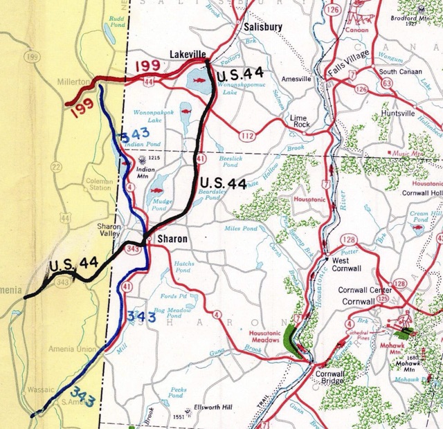 Connecticut and New York proposed rerouting US 44 along Routes 41 and 343, which were better roads at the time. Diagram from Connecticut route change application to AASHO in 1959.