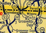
In this 1934 Texaco map (Rand McNally), Route 197 east leaving Quinebaug seems to take two directions.
In the 1920s, State Highway 151 was a 22-mile route in northeastern Connecticut, leading from Route 32 in Willington to the Massachusetts state line via Westford, North Ashford, and North Woodstock. For most or all of that time, only the segment east of today's Route 169 was signposted.
On Jan 1, 1932, most or all of SH 151 became Route 197. The 1942 highway log defines Route 197 as starting 1.34 miles west of Route 89 in Ashford, near the corner of Armitage Road and Turnpike Road. Route 197 continued 17.03 miles along Turnpike Road, Boston Hollow Road, Centre Pike and Old Turnpike Road to the state line. (See "Drive It", below, for details on following this old route.)
In 1941, most of the section between Routes 32 and 89 was dropped; the official
route started 1.34 miles west of Route 89, and continued 17.03 miles
to the state line.
In 1947, most of Route 197 was turned over to town maintenance. The new definition was Route 93 (now Route 169) to the state line, for a total of 3.78 miles.
In 1962, Route 197 was extended west to Route 171, as part
of the statewide Route Reclassification.
The very last unpaved segment of the state highway system was a 1-mile stretch of Route 197 in Woodstock. In late 1965, the state put to bid a project to pave this stretch, extending from 800 feet west of Center Road to about 250 feet east of Brickyard Road. To be fair, this had been a town road until it was transferred to the state a few years earlier.

