Route 89 dates back to 1932. Its original path, from south to north:
- Today's Route 289, leading from Route 87 in Lebanon to Route 32 in Windham
- Overlap with Route 32 and Route 66 leading to the Route 195 junction
- Today's Route 195, from Route 66 to today's Route 89
- About 1 mile of abandoned alignment north of Mansfield Hollow, between Pine Woods Lane and Atwoodville Road
- Today's Route 89, from Atwoodville Road, Mansfield, to Turnpike Road, Westford
- Nagy Road, to where the road becomes Supina Road
- An abandoned road, continuing north and slightly east, connecting to Scranton Road in Union
- Scranton Road to its end at Route 15 (now Route 190) in downtown Union
Finding Abandoned Route 89, Mansfield
About 1 mile of the original Route 89 in Mansfield is no longer open to traffic. In 1952, an earthen dam on the Natchaug River was constructed in the area, creating Mansfield Hollow Lake on the site of a swampy area known as Turnip Meadow.
The original alignment veers north of Route 89 just north of Pine Woods Lane; a trail forks to the left leading into the forest. Some of the route appears to be still paved. At the causeway over the Fenton River leading into the lake, Old 89 crosses New 89, and then follows the northern shoreline of the lake. Most of this route has pavement remaining. It then veers northeast through the woods to reconnect just south of Atwoodville Road. Here, the unnamed, unmapped road ends at Route 89 with a stop sign.
There's a good view of old Route 89 at the end of Atwoodville Road in Google Street View.
Finding Abandoned Route 89, Ashford
About 3.5 miles of the original Route 89 in Ashford and Union is no longer open to traffic; this area is mostly forest. Shown on a 1952 USGS map (hosted at UNH; 2 MB JPEG scan) is the original alignment: a dotted line leading from Nagy Road in Ashford to Town Hall Road (now Scranton Road) in Union. There are faint traces of this road from the air; it would be interesting to see what's on the ground. It's not part of a state park, and might be private property.
In 1942, this portion of Route 89 was relocated to Ferrence Road and Fish Point Road, where it is located today. The 1940s route was more curvy around the Wilbur Cross Highway intersection (now an interchange on I-84); this 1-mile segment was reconstructed and made safer in 1965.
Other old sections
At the intersection of Portland Road in Ashford, there is a short segment of old Route 89 (to the east) no longer open to traffic; it abuts private property and was the subject of a lawsuit by the town against the property owner. It was abandoned by the state in 1940 and closed by the town in 1941, but the town still owns that property.
More plans in Ashford
In 1955, the state conducted a study for rebuilding and widening about 3 miles of Route 89 from Bicknell Road to Sand Hill Road. The existing pavement was 14' with 3' shoulders (quite narrow); the proposed improvement was 22' blacktop with 6' shoulders. It appears Route 89 was widened here but not realigned, although the state does mention associating Route 89 with "an abandoned section of Mansfield Road" in Ashford in 1968. I don't have details on where that was.
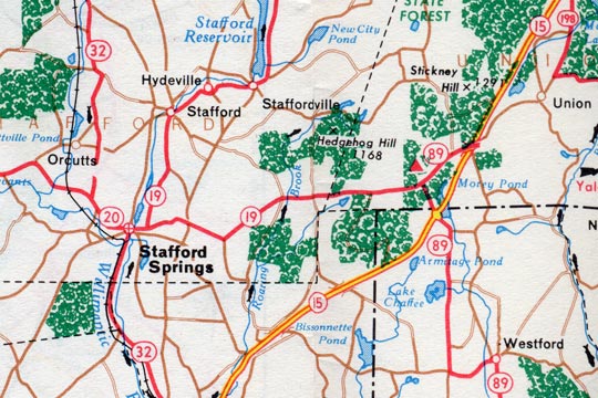
The 1961 Connecticut state highway map echoes the changes shown in the state's highway logs. For one year, Route 19 was apparently extended eastward along former Route 20 into Union.
Strange realignment retracted the following year
In the 1950s, today's Route 190 in Stafford and Union was part of Route 20. Route 20 in the area became Route 190 in July 1961, in concert with a number of changes at the opening of the Bradley Airport Connector.
In 1960, however, the state had truncated Route 20 at Stafford, and redesignated East Main Street and Buckley Highway as part of Route 19 (see map above). At the intersection with Route 89, Route 19 ended and Route 89 continued east, to end at Route 15 (now I-84), one exit beyond where those routes had already crossed.
This rerouting is bizarre. I saw the map first and thought, "OK, map error." Then when I saw the ConnDOT spreadsheet: "Possible clerical error, reflected in a map." The emergence in May 1960 of a paragraph in the Hartford Courant, meaning the Highway Department issued a press release, tips this case into the "intentional change" bucket. In any case, the decision was reversed in 1961.
Truncation in favor of Route 195, probably for UConn traffic
On Dec. 1, 1964, Route 89's south end was moved from Lebanon to Mansfield, making it shorter. Former Route 89 from Route 87 to Route 32 became the new Route 289. Former Route 89 from Route 66 to today's 89/195 intersection became part of Route 195.
I'm guessing this was done to provide a more direct route to the University of Connecticut from US 6. The Hartford Courant article announcing the change reads: "State highway officials could not be contacted to determine the reason for the change Monday night." And the story was not followed up.
Realignment predicted in 2001
Though it is lightly traveled throughout, Route 89 did get some attention near the I-84 interchange in Ashford. The Windham Regional Planning Agency in 2001 predicted that "Route 89 in particular will require realignment within the next decade if traffic volumes increase as projected." As of 2025, Route 89 has not been realigned, and there appear to be no active plans for this.

