In the 1920s, a portion of Route 195 (from Route 89 to US 44) was called
State Highway 146; however, this has also been depicted as SH 210.
In 1932, the original Route 195 was laid out, extending 5.62 miles from Route 89 at Mansfield Center to US 44, replacing SH 146. Today's Route 195 includes this segment, which passes by the University of Connecticut.
Leading south from Mansfield Center was a longer Route 89 that continued to Lebanon. To the north, the segment of today's Route 195 between US 44 and Route 32 did not yet exist. The segment from Route 32 to Route 74 was unposted SR 809. Jones Crossing Road is part of the original alignment of SR 809.
In 1962, a new segment of Storrs Road was constructed between Route 32 and US 44, as an extension of SR 809. The work included a short realignment of SR 809 to create a four-way intersection.
In 1963, Route 195 was extended north along SR 809 to reach Route 74 in Tolland.
On Dec. 1, 1964, Route 195 was extended south to US 6 (now Route 66), replacing Route 89, which was truncated at their junction. I'm guessing this change (and the northerly extension in 1963) was done to improve access to the University of Connecticut. The Hartford Courant article announcing the change reads: "State highway officials could not be contacted to determine the reason for the change Monday night." And the story was not followed up.
Route 195 Bypass once planned
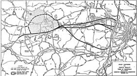
Three corridors for the proposed Route 195 bypass were examined, as shown in this Dec. 1970 map. (
Larger Image)
In 1970, the state proposed building a "Super 4" bypass (four lanes, undivided, but with grade separations) for Route 195 west of the University of Connecticut. In March 1971, the state released a more detailed study, including a recommended corridor ("B") of the three that were examined.
The $13.8 million highway would be 52 feet wide, 4 lanes undivided, with a 150 foot right of way. Access would be controlled, but all intersections would be at-grade.
The preferred alignment would start at US 6 (formerly I-84) west of Route 195. The highway would overpass Meadow Brook Ln., then intersect Puddin Ln., Crane Hill Rd., Browns Rd., Spring Hill Rd. and Maple Rd. After overpassing Davis Rd., the highway would intersect Route 275.
North of Route 275, all three corridors were identical, and would be integrated in the west leg of a proposed loop highway around the University of Connecticut. Going slightly east of Separatist Rd., the planned highway would intersect SSR 430, and US 44 (formerly US 44A) before ending at current Route 195, west of Cedar Swamp Rd.
In Jan. 1972, the Mansfield Transportation Committee recommended that the state delay the bypass, but retain the design work done for future use. The state said there were no funds for the bypass, and nothing would be considered until I-84 (now I-384) was completed to Hartford. Meanwhile, state and town agreed to do no major widening of Route 195, to "preserve the historical and residential nature of the road."
By 1978, the plan was considered inactive, and has not been resuscitated since then.
Increasing Traffic Spurs Studies
Both the University of Connecticut and growth in Tolland have contributed to more traffic on Route 195. In 1978 the Windham Regional Planning Agency (WRPA) issued "Analysis of the Route 195 Corridor Transportation Needs", with some recommendations that have been followed. It was widened between Eastbrook Mall (near US 6) and Puddin Lane at some point; and its intersection with US 44 (Mansfield Four Corners) was reconstructed in 1992.
The planned Interstate 84 eastern extension would have affected Route 195 traffic as well. Its cancellation led to the "I-84 Interstate Trade-in Concept Plan," a series of improvement projects to handle east-west traffic in the Windham and Killingly areas. These included upgrades to Route 195 between US 44 and US 6.
In the 1990s, these projects were re-evaluated amidst a growing sentiment of preservation of rural character; in particular, Mansfield opposes any changes to the character of the road. Around 1993, ConnDOT proposed adding Route 195 to the National Highway System, making it eligible for certain federal funding; Mansfield appealed to drop it and won. In 1994, the town applied for scenic road designation, which was not granted.
As town and state could not agree on the scope of work to be done, no major work has been done on Route 195 in Mansfield.
However, Discovery Drive, a parallel route through UConn's North Campus connecting US 44 with North Eagleville Road (SSR 430), helps relieve some Route 195 traffic.
Small-scale improvements
Although no bypass or large-scale widening has been done, the state has improved Route 195 in a few areas.
- South of I-84, four lanes with a median alongside a shopping center
- four lanes between Route 320 and US 44
- four lanes near US 6 and the East Brook Mall
Not an old alignment
Flaherty Road, south of Storrs, seems like a crooked older alignment of Route 195. However, maps show the "new" section of Storrs Road dating back to the 1920s or earlier.

