Route 61 is a rural highway serving Woodbury, Bethlehem and Morris. It used to extend to Cornwall.

Updated Sept 20, 2024
 |
Route 61 is a rural highway serving Woodbury, Bethlehem and Morris. It used to extend to Cornwall.
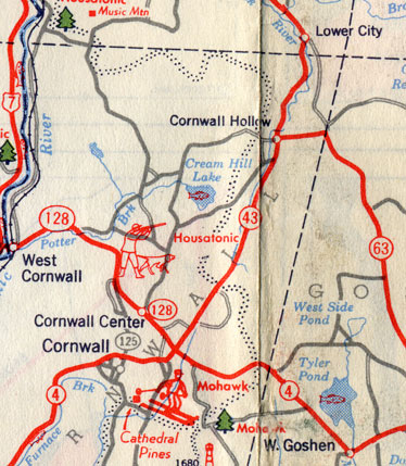 The Cornwall area in this 1949 state map shows the old alignment of Route 63 (formerly 61) near Route 43.
Route 61 was commissioned in 1932, from part of old State Highway 130. Its original extent (25.17 miles) was from US 6 in Woodbury to Route 43 in the Cornwall Hollow section of Cornwall:
In 1943, the segment north of Route 109 was transferred to Route 63. Route 61 was now 9.14 miles long.
County Road in Morris, part of Route 61, was not shown as a state road through the 1940s and 1950s on most maps. Route 61 was shown to end at Route 109, and either overlap a short distance east before continuing north (before 1943) or ending at Route 63 (after 1943).
However, the length (9.14 miles) in the 1944 log implies County Road was part of the route. The length if Route 61 were to overlap Route 109 to end at Route 63 is only 8.25 miles.
In the ConnDOT spreadsheet, there is a notation for 1962: "[Route 61] assigned to part of Alain White Road." This road, now entirely local, branches off County Road just north of Route 109.
Sometimes sources disagree, and it's a little maddening. So I don't have a definitive answer on Route 61 north of Route 109.
The intersection at US 6 in Woodbury has some safety problems; as of 2024, ConnDOT is proposing a roundabout there.
Something fun for Route 61, and not entirely practical:
The new length of Route 61, extending from Seymour to Morris, would be about 27.7 miles.