The Map Inside: Connecticut Officials: 1998
This exhibit shows how the Connecticut official tourist map has changed since the 1930s. You can start with the introduction or browse year to year. The scans may not be actual size (150 dpi), but are consistent with each other.
Other years:
1930
1934
1935
1938
1941
1942
1943
1949
1952
1955
1956
1957
1959
1960
1961
1963
1965
1971
1972
1975
1989
1998
2000
2001
2002
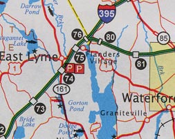
The 1998 map is the first one to be obviously computer-generated, enabling such advances as three-color interstate shields. Non-state roads are thin red lines, making the map look a bit bloodshot; state roads (even secret ones) are still made distinctly thicker.
I don't like the new look (it's a bit noisy) but it's not that bad. We see some problems with one kind of metadata overwriting another (such as "Flanders Village" over US 1). The changes at the state level are nowhere near as abject as the abandonment of good city detail (right).
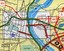
The city insets did not survive the transition as well as the main map. A lot of detail has been lost compared to earlier maps.
No grade separations are shown; everything's been flattened. The ramps are scattered indifferent line segments that give you no hint as to what access the interchanges provide. I-91 and the Whitehead Highway seem not to have any ramps in Hartford.
Please compare with the 1975 city inset to see what has been lost. (Fortunately, inset quality was improved in the 2000 map.)