The Map Inside: Connecticut Officials: 1943
This exhibit shows how the Connecticut official tourist map has changed since the 1930s. You can start with the introduction or browse year to year. The scans may not be actual size (150 dpi), but are consistent with each other.
Other years:
1930
1934
1935
1938
1941
1942
1943
1949
1952
1955
1956
1957
1959
1960
1961
1963
1965
1971
1972
1975
1989
1998
2000
2001
2002
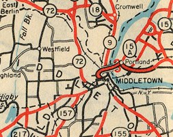
In 1943 many more secondary roads were added to the map. Note the increased detail around Westfield and southeast of downtown Middletown, compared to the same area shown in 1942.
The north-south town road through Westfield would in 1963 become Route 217.
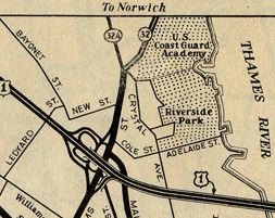
The US 1 freeway and Gold Star Bridge opened this year. US 1 is now part of I-95, and the interchange with Route 32 was completely revamped around 1975.
Note the Route 32A marker applied to the former Route 32. The four-lane Route 32 had been open for a few years already, and Route 32A appears nowhere else in official Connecticut tourist maps. I'm not sure how long the road was signed that way (if ever).