The Map Inside: Connecticut Officials: 1957
This exhibit shows how the Connecticut official tourist map has changed since the 1930s. You can start with the introduction or browse year to year. The scans may not be actual size (150 dpi), but are consistent with each other.
Other years:
1930
1934
1935
1938
1941
1942
1943
1949
1952
1955
1956
1957
1959
1960
1961
1963
1965
1971
1972
1975
1989
1998
2000
2001
2002
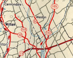
Shown is the Wilton - Weston area, with two highways (routes 103 and 105) that were turned over to the towns in 1963. The cartographer, General Drafting, is using nearly the same style as it did for the 1949 map, its first official one for Connecticut.
Note the stylized ramps at Merritt Parkway interchanges. By the 1960s, Connecticut maps had moved to the plain white square to depict an interchange, except in city insets.
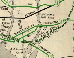
Part of the Bridgeport inset is shown, about 2 miles east of the 1956 snapshot. The Connecticut Turnpike would open in early 1958.
Today, US 1 goes along the 1957 US 1A alignment, and Route 130 follows the old US 1.