The Map Inside: Connecticut Officials: 2002
This exhibit shows how the Connecticut official tourist map has changed since the 1930s. You can start with the introduction or browse year to year. The scans may not be actual size (150 dpi), but are consistent with each other.
Other years:
1930
1934
1935
1938
1941
1942
1943
1949
1952
1955
1956
1957
1959
1960
1961
1963
1965
1971
1972
1975
1989
1998
2000
2001
2002
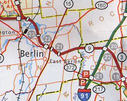
This map section shows the Berlin area, between New Britain and Cromwell. Compared to the 2000 map, we can see a different font for town names, slightly different background colors, and gray exit numbers instead of black. I think these changes have made the map more readable, which was probably the intent.
Notice the Berlin Turnpike, a four-lane divided highway, is drawn with a single line instead of double. Other divided non-expressways, like US 5 in South Windsor, are drawn the same way. Past maps used to distinguish these roads with double red line, a convention that I hope will be reinstated.
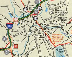
Danbury was inadvertently left out of the city insets in 2000, but returned in 2002. Welcome back, Danbury.
The red road leading south from I-84 exit 3 is US 7; for decades, this was to be the north end of a "Super 7" expressway leading to Norwalk.