The Map Inside: Connecticut Officials: 1949
This exhibit shows how the Connecticut official tourist map has changed since the 1930s. You can start with the introduction or browse year to year. The scans may not be actual size (150 dpi), but are consistent with each other.
Other years:
1930
1934
1935
1938
1941
1942
1943
1949
1952
1955
1956
1957
1959
1960
1961
1963
1965
1971
1972
1975
1989
1998
2000
2001
2002
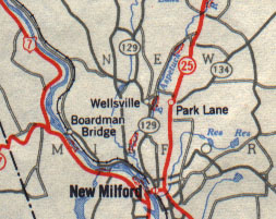
General Drafting handled the cartography from 1949 to 1960. Four-lane roads and divided highways (none shown here) were drawn in black-bordered red lines. Paved state highways were red, other roads, including merely surfaced routes, are gray.
Route 129, the Merryall road decommissioned in 1963, was surfaced but unpaved. Route 134, which had not been shown on state maps since 1940, makes a surprise reappearance. It appears to have been officially canceled in 1956. Signs might have been removed earlier.
Route 130, whose death may have also been exaggerated, appears in gray elsewhere on this map, as well as routes 199, 132, and 108, which were presumably unpaved in 1949.
The portion of Route 25 shown here became US 202 in 1974. Route 134 is now part of Route 109.
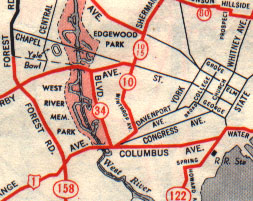
General Drafting brought color to the city maps, using the same road and route markings as on the main map. Here's a view of New Haven before the Connecticut Turnpike, I-91, and the Oak Street Connector freeways were built.
Route 158 is now part of Route 122, which was moved. Route 15, the number given the previous year to the Merritt and Wilbur Cross Parkways, was temporarily routed through New Haven until the Wilbur Cross was complete. Route 34's final stretch, simply called Boulevard, is abbreviated to a lost-context "BLVD."
Route 80 crosses upper New Haven to end at Route 10. That routing would still be useful.