The Map Inside: Connecticut Officials: 1955
This exhibit shows how the Connecticut official tourist map has changed since the 1930s. You can start with the introduction or browse year to year. The scans may not be actual size (150 dpi), but are consistent with each other.
Other years:
1930
1934
1935
1938
1941
1942
1943
1949
1952
1955
1956
1957
1959
1960
1961
1963
1965
1971
1972
1975
1989
1998
2000
2001
2002
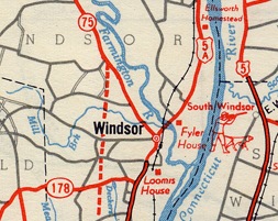
The only "dotted-line" highway on the 1955 map is the extension of the North Meadows Expressway to Route 75 in Windsor (the 1956 map shows it open to traffic). It might have been signed US 5A for a short while, but eventually became part of Interstate 91.
The US 5A shown here became state route 159 in 1968.
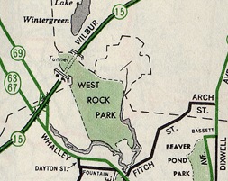
Shown here is West Rock Park and surroundings in New Haven, site of the only underground highway tunnel in Connecticut. The tunnel graphic looks almost whimsical compared to the optimized, stylized artwork on most modern maps. The West Rock Tunnel, located on the Wilbur Cross Parkway, opened in 1949.