The Map Inside: Connecticut Officials: 1956
This exhibit shows how the Connecticut official tourist map has changed since the 1930s. You can start with the introduction or browse year to year. The scans may not be actual size (150 dpi), but are consistent with each other.
Other years:
1930
1934
1935
1938
1941
1942
1943
1949
1952
1955
1956
1957
1959
1960
1961
1963
1965
1971
1972
1975
1989
1998
2000
2001
2002
Engineering Services of St. Louis did the cartography for only this year. In 1957, General Drafting took over again. However, the route number font here looks a lot like that used by the DOT starting in 1963.
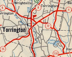
Torrington's downtown may have retained a lot from the 1950s, but the surrounding highway system has not. Every route seen here, except Route 4 west from W. Torrington, has been renumbered, rerouted, or (Route 8) upgraded to an expressway. Route 72 continued north-northwest along today's Route 272 to the Massachusetts state line.
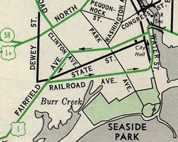
Part of the Bridgeport inset is shown. It looks a bit different without Interstate 95.
Today, US 1 goes along the 1956 US 1A alignment, and Route 130 follows the old US 1.