The Map Inside: Connecticut Officials: 1942
This exhibit shows how the Connecticut official tourist map has changed since the 1930s. You can start with the introduction or browse year to year. The scans may not be actual size (150 dpi), but are consistent with each other.
Other years:
1930
1934
1935
1938
1941
1942
1943
1949
1952
1955
1956
1957
1959
1960
1961
1963
1965
1971
1972
1975
1989
1998
2000
2001
2002
The cartography here shows only few changes from the 1941 map. The surrounding states are shaded yellow and Connecticut white (the reverse was true the previous year). Where a 1941 marker would show "6 & 202" for paired US routes 6 and 202, the 1942 omits the ampersand (which looked too much like an "8".)
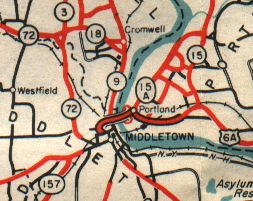
Above is the Middletown area in 1942. US 6A (now Route 66) might have been widened to four lanes divided when the Arrigoni Bridge opened in 1938.
Notice the network of unnumbered red roads in Portland: these were all state-maintained roads with "secret" route numbers above 400. In the early 1960s route reclassification, these were turned over to the town.

Instead of a city map, this year we show part of the Merritt Parkway detail section, which was added to the state highway map in 1941. The Parkway's exits were not numbered until 1947, so the interchange detail in context was essential for drivers unfamiliar with the new highway. (More trivia: the Parkway didn't have a posted route number until 1948.)