The Map Inside: Connecticut Officials: 1952
This exhibit shows how the Connecticut official tourist map has changed since the 1930s. You can start with the introduction or browse year to year. The scans may not be actual size (150 dpi), but are consistent with each other.
Other years:
1930
1934
1935
1938
1941
1942
1943
1949
1952
1955
1956
1957
1959
1960
1961
1963
1965
1971
1972
1975
1989
1998
2000
2001
2002
The practice of marking unimproved state highways in gray (shown in 1949 map) is gone, perhaps because all routes are now paved. Expressways and divided highways (not shown here) are marked identically, as shown in the 1959 map.
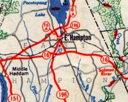
This scan of East Hampton shows US 6A (now state route 66) and Route 16A (now Main Street, a town road).
Sometime between 1949 and 1952, General Drafting moved to green and black for the city insets. Otherwise, the cartography was the same as in 1949.
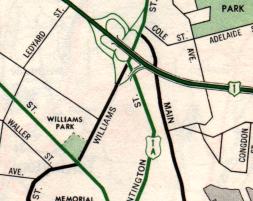
The New London inset doesn't include much detail by modern standards. Among the expanses of white space are the US 1 expressway (now I-95) and its interchange with Route 32 (upgraded in the mid-70s to a freeway-to-freeway interchange).