The Map Inside: Connecticut Officials: 1998 PDF vs. 1999
This exhibit shows how the Connecticut official tourist map has changed since the 1930s. You can start with the introduction or browse year to year. The scans may not be actual size (150 dpi), but are consistent with each other.
Other years:
1930
1934
1935
1938
1941
1942
1943
1949
1952
1955
1956
1957
1959
1960
1961
1963
1965
1971
1972
1975
1989
1998
2000
2001
2002
I didn't expect any changes for 2001, since the next biennial official map will be released in 2002. However, ConnDOT updated their online PDF town maps this year. The changes are notable enough to merit comment here.
ConnDOT provides a great service by making available town maps for all 169 Connecticut towns. These PDF maps show nearly all (if not all) public roads by name, all state highways (except the 900 series) by number, and all interchanges with ramp detail.
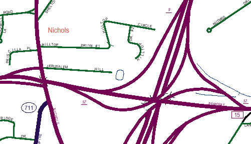
Above is an earlier map (Dec. 31, 1998), shown at 600% magnification, with detail around the Route 8/Route 15 interchange in Trumbull. Signed state routes (like 15), unsigned "secret" routes (like 711) and local streets are differentiated by color. Interstate routes (not shown here) are in gold. Some maps have thick road lines like Trumbull's, and others have hairlines.
Exit numbers (such as Exit 9 for Route 8 southbound to Route 15) are italicized and underlined.
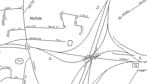
Above is the later map (Dec. 31, 1999), same magnification, of the same area. The newer maps are black and white, which makes it more difficult (or in some cases impossible) to determine exactly which portions of road are state maintained or not. (However, you can compare the map to the highway log.)
The newer maps have also gone to hairlines for roads, which in general does make them more readable.
Note that "Exit 9" in the old map has become Exit 10.
The new maps also feature a graphic of the state and its town borders, with the town being mapped filled in.
In the passing years, the town maps have been changed back to full color.