The Map Inside: Connecticut Officials: 1941
This exhibit shows how the Connecticut official tourist map has changed since the 1930s. You can start with the introduction or browse year to year. The scans may not be actual size (150 dpi), but are consistent with each other.
Other years:
1930
1934
1935
1938
1941
1942
1943
1949
1952
1955
1956
1957
1959
1960
1961
1963
1965
1971
1972
1975
1989
1998
2000
2001
2002
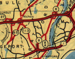
All state-maintained roads are drawn in red on the main map. Even secret routes, such as the unmarked route (old SR 411) branching north from Route 65 in Nichols, are included.
Red roads with black outlines are literally "super highways," an honor given to any road with four or more lanes. New parkways such as the Merritt and Milford are drawn the same way as city streets such as US 1 in Stratford. Even on the main map, some degree of ramp detail is shown at interchanges.
Disoriented? Don't feel bad. The Merritt Parkway (slightly above center) was not called Route 15 until 1948. Route 65 became Route 8, which then became a freeway; Route 113 became part of Route 108, and most of the old Route 8 is now Route 110.
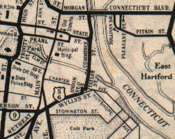
City maps were black and white, with finer detail. The scan doesn't quite do justice to the hairline details of riverbanks and streams.
This Hartford map predates the Charter Oak Bridge by a year; the Founders, Putnam, and Bissell Bridges did not appear until the late 1950s. US Routes 5, 6, and 44 all cross on the Bulkeley Bridge, a stone arched crossing built in 1907 that now carries I-84.