The Map Inside: Connecticut Officials: 2000
This exhibit shows how the Connecticut official tourist map has changed since the 1930s. You can start with the introduction or browse year to year. The scans may not be actual size (150 dpi), but are consistent with each other.
Other years:
1930
1934
1935
1938
1941
1942
1943
1949
1952
1955
1956
1957
1959
1960
1961
1963
1965
1971
1972
1975
1989
1998
2000
2001
2002
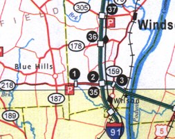
In 2000, the state started marking HOV lanes (high occupancy vehicle; namely carpools, vans and buses) with black diamonds, as shown here for I-91. The HOV lanes run in the median, between the general-purpose lanes, and offer their own exit and entrance ramps. (A possible enhancement would be to indicate exactly at which points HOV traffic can enter and exit; not every interchange offers HOV access. The placement of the diamonds themselves does not indicate this.)
The "super 2" highway leading west of I-91 (exits 1 and 2) is actually the long exit ramp to Route 218 from the end of I-291.
And finally, note the perfectly straight border between (yellow) shaded and unshaded areas. Starting in 1998, the borders no longer mean "urbanized area"; they simply mean "area shown in more detail in an inset."
The city insets are generally improved in legibility and quality from 1998. In this map, the state added insets for the Mohegan - Mashantucket area and Bradley International Airport, and expanded the New London - Groton inset to include Mystic. These changes reflect the increasing tourist focus of the highway map (which has been called the Tourist Map for some time now.)
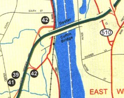
This sample, from the Bradley area map, shows I-91 crossing the Connecticut River from Windsor Locks to East Windsor. For the first time, a few "secret route" numbers inadvertently appear on the official DOT map, such as SR 510 here. (In the 2002 map, the SR 510 marker has been removed).