The Map Inside: Connecticut Officials: 1961
This exhibit shows how the Connecticut official tourist map has changed since the 1930s. You can start with the introduction or browse year to year. The scans may not be actual size (150 dpi), but are consistent with each other.
Other years:
1930
1934
1935
1938
1941
1942
1943
1949
1952
1955
1956
1957
1959
1960
1961
1963
1965
1971
1972
1975
1989
1998
2000
2001
2002
This map and the following year's were drawn by National Survey, a Vermont company that has made road maps since the 1920s. The style is quite distinct from the 1950s General Drafting maps and the in-house DOT maps starting in 1963.
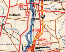
Route 20 through Enfield was renumbered as part of Route 190 in 1961, during changes to several area highways leading from the July 1961 opening of the Bradley Airport connector in Windsor Locks.
In this map, Route 190 crosses over the old Thompsonville Bridge, which has since been demolished (though the pilings remain). The current four-lane bridge carrying Route 190 opened in 1967, and the short 190 freeway opened around the same time.
US 5A on the Connecticut River's west bank is now called Route 159.
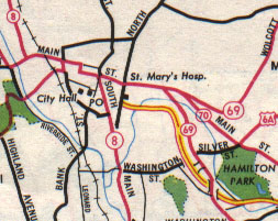
Another view of Waterbury (see 1960). The Waterbury Expressway (shown in yellow) is now part of Interstate 84. Though a few segments of I-84 were open in 1961, including the entire Wilbur Cross Highway section from Manchester eastward, the map doesn't show I-84 markers anywhere.
The Route 8 freeway is about six years in the future; its interchange with I-84 is featured on the cover of the 1969 state map. Toward the end of the 1960s, as I-84 was completed, Route 70 was cut back to the I-84 interchange, and much of US 6A in Waterbury turned over to the city.