The Map Inside: Connecticut Officials: 1959
This exhibit shows how the Connecticut official tourist map has changed since the 1930s. You can start with the introduction or browse year to year. The scans may not be actual size (150 dpi), but are consistent with each other.
Other years:
1930
1934
1935
1938
1941
1942
1943
1949
1952
1955
1956
1957
1959
1960
1961
1963
1965
1971
1972
1975
1989
1998
2000
2001
2002
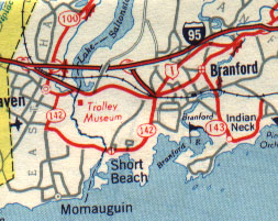
Road and marker drawing had not changed much from 1949, save for the new Interstate marker needed for I-95. No "secret" routes are marked in red, except for short expressways such as the Branford Connector (now SR 794).
Route 143 was absorbed by Route 146 in 1963.
The green and black inking for city insets was used for most of the 1950s.
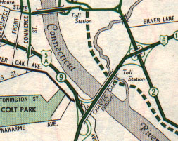
The existing Route 2 here is Main Street (now SR 517) in East Hartford; the Route 2 expressway is proposed to the west. The cloverleaf at Route 15 and Main Street was modified to a four-ramp interchange in conjunction with the replacement of the Charter Oak Bridge in in 1991. Since 1970, US 6 has now crossed with I-84 on the Bulkeley Bridge instead of with US 5/CT 15 on the Charter Oak.
The Conland Highway (Route 9 and US 5A) is now part of Interstate 91; Route 9 was rerouted south in 1963. To avoid filling this page with everything that's changed in 50 years, I'll conclude with pointing out the new (to 1959 drivers) State Street bridge near the top of the map, soon after renamed the Founders Bridge.