The Map Inside: Connecticut Officials: 1960
This exhibit shows how the Connecticut official tourist map has changed since the 1930s. You can start with the introduction or browse year to year. The scans may not be actual size (150 dpi), but are consistent with each other.
Other years:
1930
1934
1935
1938
1941
1942
1943
1949
1952
1955
1956
1957
1959
1960
1961
1963
1965
1971
1972
1975
1989
1998
2000
2001
2002
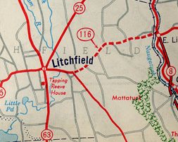
Route 116 (today's Route 118) might be the newest 2-lane road shown as "under construction" on official state maps. The new road, which parallels East Litchfield Road, opened in 1961. Route 116 became Route 118 in 1966.
The new Route 116 (118) is limited access, but only in the sense that the state controls what can intersect it. There are only a few intersections with the road and few or no driveways. Route 118 is erroneously shown as a freeway on some maps.
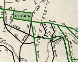
A view of Waterbury (no route markers in scan boundary). East and West Main Street are former US 6A. South Main is part of former Route 8. The expressway is now part of Interstate 84.