The Map Inside: Connecticut Officials: 1989
This exhibit shows how the Connecticut official tourist map has changed since the 1930s. You can start with the introduction or browse year to year. The scans may not be actual size (150 dpi), but are consistent with each other.
Other years:
1930
1934
1935
1938
1941
1942
1943
1949
1952
1955
1956
1957
1959
1960
1961
1963
1965
1971
1972
1975
1989
1998
2000
2001
2002
The 1989/1990 map introduced new route markers. I don't think they looked as good. There tended to be alignment problems within the ovals as well.
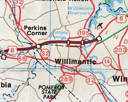
Symbolizing this loss is Willimantic (pictured), which was served by a fragment of Interstate 84 from about 1971 to 1984. When the state decided not to pursue extending I-84 to Rhode Island, Willimantic's interstate was demoted to US 6.
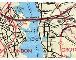
Though the DOT still kept the old design for detail maps, they were using different tools to make updates. Compare the ramps for the Route 32/I-95 interchange (newer) to the Route 349 ramps (older): the existing ramps are more finely done. The grade separations in the older work look better as well.
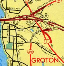
One map typo in 1987 displayed Route 349 as Route 350, below: