The Map Inside: Connecticut Officials: 1975
This exhibit shows how the Connecticut official tourist map has changed since the 1930s. You can start with the introduction or browse year to year. The scans may not be actual size (150 dpi), but are consistent with each other.
Other years:
1930
1934
1935
1938
1941
1942
1943
1949
1952
1955
1956
1957
1959
1960
1961
1963
1965
1971
1972
1975
1989
1998
2000
2001
2002
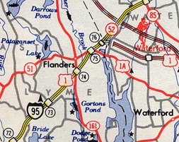
Here's a scan from southeast Connecticut. The roads are different now: Route 51 and US 1A are both part of US 1, and Route 52 is now I-395. The proposed freeway at upper right, Route 11, is still proposed.
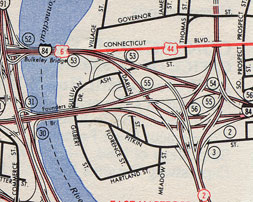
Here's the detail of the Bulkeley Bridge area in East Hartford -- a close-up of the Hartford vicinity detail shown on the 1972 page. With very ramp distinctly shown, you can see how many gory left exits and weaves there are. Nasty freeways, but a very nice map.