The Map Inside: Connecticut Officials: 1965
This exhibit shows how the Connecticut official tourist map has changed since the 1930s. You can start with the introduction or browse year to year. The scans may not be actual size (150 dpi), but are consistent with each other.
Other years:
1930
1934
1935
1938
1941
1942
1943
1949
1952
1955
1956
1957
1959
1960
1961
1963
1965
1971
1972
1975
1989
1998
2000
2001
2002
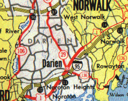
On the main map, all numbered highways, even the unsigned secret roads, are shown in red. Four-lane and wider surface streets, like US 1, have thicker lines; in urban areas like Stamford (left) and Norwalk, all streets are shown thinner to allow more detail. Both I-95 and the Merritt Parkway were toll roads at the time, and shown in yellow.
Route 29 became present-day Route 124 in 1966.
The 1965 map provided this level of detail for about 10 cities. At the time, these city blowups were on the reverse side of the map. By 1968, they had moved to the front, covering what would be Long Island and Rhode Island.
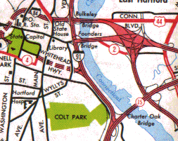
Each ramp is shown separately, along with each grade separation. Route 2 is shown along Pitkin Street because the large 2-84 interchange had just been completed. The unfinished road heading north would have been a relocated US 5 expressway, later known (but never built) as I-284.