
Updated Oct 20, 2018
State route 189 starts in West Hartford, near the University of Hartford, and leads to the Massachusetts state line, serving Bloomfield, Tariffville, and Granby. Though it's a modest road —two lanes for most of its length—for decades the state had mulled over several plans for freeways in the 189 corridor.
Such plans were abandoned in 1973, and no upgrades are planned in the area now. Two vestiges of the earlier proposals remain: a high-powered but underused interchange on Interstate 84, and a short freeway in North Bloomfield.
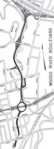 Proposed Woods River Boulevard, from 'Coordinated Transportation Plan - larger image
The first citation I've seen for a freeway in this corridor was a 1947 transportation plan published by the Hartford Department of Engineering. The freeways proposed included a downtown loop, roughly along I-84, I-91, and the Whitehead Highway (now SR 598), with a few spur routes (see details). Also planned was a parkway route along the North Branch of the Park River, from Capitol Avenue to Homestead Avenue. As a tribute to the older name of the North Branch, planners called this route Woods River Boulevard (WRB).
The WRB would be divided, grade-separated and access controlled; much like the planned freeways, but with nicer landscaping. Starting at New Park Avenue, the boulevard would tunnel under Park Street, then follow the river northerly to end at the proposed Northwest Expressway, just south of Homestead Avenue. The following interchanges were planned:
Parks and other open spaces were seen at the time as favorable places to locate new highways. The city plan presents the Woods River road as if a lightbulb went off in an engineer's head.
In the western part of the city opportunity exists to develop an excellent north-south route... along the edge of the floodway of the river locating in a landscaped reservation which would combine the highway right-of-way with a protective belt along the river... A most attractive and scenic route could be developed through land not particularly suitable for building.
The boulevard would relieve north-south traffic on nearby streets and provide feeder routes to the two expressways it connected.
The engineering firm of Andrews and Clark published in 1949 an Arterial Plan claiming to correct various deficiencies of three previous Hartford plans (state, 1945; Flood Commission, 1946; and city, 1947). Well-known New York power broker Robert Moses weighed in with a foreword agreeing with Andrews and Clark's proposals.
Though the report emphasized traffic in the central business district, the authors recommended reserving space for the WRB before it was too late:
West of the business district an unusual opportunity exists for a feeder between the East-West Expressway and Albany Avenue to server the large residential neighborhood in the area. It should be built as a parkway, limited to pleasure vehicles, and generous landscaped borders should be provided... while its construction could be deferred for some time, the right-of-way should be acquired soon before building development, now encroaching, catches up with it.
Neither the Northwest Expressway nor the Woods River Boulevard were ever built. However, the East-West Expressway was built, and is now Interstate 84. Exit 46 (Sisson Avenue), with unused expressway connections to the north, is situated very close to where the East-West/Woods River interchange was planned, and the unbuilt expressway would have followed the Woods River corridor.
More on Exit 46 follows.
By 1955, the WRB was known as the Woods River Circumferential Expressway, a slightly misleading moniker in today's age of beltways. As it turns out "circumferential" did not mean "encircling Hartford", but instead meant "perpendicular to the radial routes going into Hartford." The Expressway would still be mainly straight, running north and south.
A system of freeways in Hartford and West Hartford were being laid out in the 1950s (1955 M. Alfred Kaehrle study):
The WRE would start at the Sisson Avenue Connector (indirect access to the East-West Expwy), continue north to cross the Northwest Expwy, and terminate at the US 44 expressway near the corner where Hartford, West Hartford and Bloomfield meet. Its purpose: connect the radial freeways, improve north-south traffic flow, and relieve traffic on Albany, Asylum, and Farmington Avenues.
Furthermore, the Newington Avenue connector would effectively extend the expressway south.
Starting at the Sisson Avenue connector, the WRE would provide interchanges at Woodland Street and Farmington Avenue (combined), Asylum Avenue, Albany Avenue, the Northwest Expressway, and relocated US 44. Near the Northwest Expressway, the WRE's roadways would be separated to allow direct ramps and the Park River to run between them.
The 1955 Kaehrle study also discussed a northern extension (deemed not important at the time) and a southern extension to the Berlin Turnpike where routes 5 and 15 split off. The southern extension was partially addressed by the Flatbush Avenue connector (SR 504) from I-84, and early plans to locate Route 9 from there to the Berlin Turnpike.
On Jan. 11, 1960, a one-mile section of expressway opened in North Bloomfield near the Farmington River. Signed as part of Route 9, it offered a partial cloverleaf at Tariffville Avenue, and a trumpet interchange where Route 9 left the mainline toward Tariffville and Route 187 continued toward East Granby.
This project arose from local needs (relocating Route 9 from a substandard road across the Farmington River) but was underway as plans were afoot for a Route 9 freeway leading all the way to I-84 in Hartford. However, the North Bloomfield freeway, now part of Routes 187 and 189, remains isolated today. For all Connecticut's cancelled and curtailed plans, nearly all of its freeways are connected. US 6 in Willimantic and Route 78 in Stonington are the only other unconnected freeways in the state.
In 1963, Route 187 was extended along Blue Hills Avenue to Hartford, and Route 9 was renumbered to Route 189 in the area. Route 187 now overlapped with Route 189 between the trumpet and the Tariffville Road exit.
In the late 1980s, when Route 187 was widened to a four-lane divided road nearby, the mainline from the 187/189 expressway south was shifted to Route 187, where Route 189 joined at a T-intersection. Tariffville Road is no longer part of Route 187.
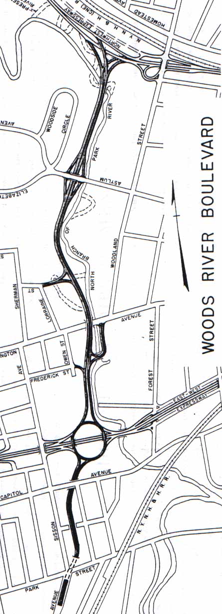
Exit 46 on Interstate 84 is simply marked "Sisson Avenue:" no further destination or connecting route, no service stations, no hotels, not much of anything. Nonetheless, Exit 46 is an elevated three-level interchange, with long ramps for Sisson Avenue to the west, and closed-off provisions for ramps to the north. I can't fault the average passerby for wondering "what was ConnDOT thinking?"
However, the Sisson Avenue connection (mentioned in the 1955 Kaehrle report, above) was incidental to Exit 46. The "Evel Knievel" ramps to the north (nicknamed for what would happen if you drove off the edge) were where the Route 189 Expressway would start. A few other "overgrown" interchanges on I-84 (exits 39A, 43, 45, and 48) were built that way for similar reasons.
The Sisson Avenue ramps were given a "secret" route number by the state: SR 503.
Exit 46 is now endangered. The 1999 "Hartford West" transportation plan involves some safety and flow improvements on I-84, including a "reduction in profile" of the interchange. The left exit from I-84 eastbound does not help its case, as left exits are now deprecated. The current favorite among the presented alternatives is a single-point urban interchange (SPUI).
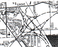 Possible configuration for proposed I-291/CT 189 freeway interchange, from Champion Hartford area map
By the 1960s, the Woods River name had been dropped from highway plans. The proposed Route 189 Expressway would start at Interstate 84 in Hartford and follow the Park River North Branch into Bloomfield. Interchanges were planned at Sisson Avenue (in conjunction with I-84 at exit 46), Farmington Avenue, US 44, and Interstate 291, with a probable connection to Route 218.
In 1961, the plan was formally shelved at the request of the Hartford Commission on the City Plan; it was felt that an expressway would not be compatible with residential uses in the corridor.
However, the route was still under discussion, and the City Plan Commission held a meeting in March 1962. (I'm also a little confused regarding the "formally shelved.") The state highway department called it a critical commuter route from Granby and Bloomfield into Hartford. Corridor traffic in 1975 was projected to overwhelm all existing streets if Route 189 was not built, and a six-lane expressway was recommended.
In April 1962, the City Plan Commission told the City Council of its opposition to the six-lane expressway proposal, saying it was much bigger than the boulevard proposed in 1955.
In November 1965, the City Plan Commission asked the state highway department to study a smaller-scale highway here, called the "North Park River Greenway." This four-lane surface grade parkway, trimmed down from the earlier six-lane expressway plan, would lead from I-291 in Bloomfield to I-84 exit 46.
Though the south end was well-determined, there were several alternative proposals for the northern terminus of Route 189. In the Interregional Planning Association 1966 expressway plan, the terminus was left "as is," ending at the 187/189 split built in 1960. In 1967, the state Long-Range plan concurred, while the "Plan for the Future" connected Route 189 with a proposed Route 10 freeway in Granby. At the same time, the Capitol Planning Region instead proposed a connection with Route 20 west of Bradley International Airport, continuing through Suffield as a proposed Route 190 extension to Enfield. The 1975 state expressway plan extended Route 189 from North Bloomfield to meet with Route 20 at its split from the Bradley Airport Connector (SR 401).
While the larger Woods River Expressway was under discussion, the state was prepared to build the first 1/2 mile as a connector from I-84 to Farmington Avenue. The intent was to secure 90% federal funding for the road; however, the federal government ruled that since it was the start of a proposed new expressway -- not just a connector road -- it was only eligible for 50/50 funding. This decision caused the state to defer building the connector in 1962.
In summer 1965, the connector plan was floated again, this time with state funds, and bids were to be issued the following winter. However, the connector was never built.
On Jan. 26, 1973, the DOT announced it was dropping the Route 189 freeway plan in favor of a bus route from Hartford to Bradley International Airport.
Needs still exist for transportation in the area, as Routes 185, 187, and 189 suffer high levels of service. In the 1990s, the state examined rehabilitating the Griffin Line railway for passenger service in the corridor, but turned away from that solution as well. What remains are two interesting artifacts reminding us of what was planned decades ago.